Kansas Severe Weather Setup Stalls on a Critical Question as Storm Fuel Builds but a Dry Surface and Missing Trigger Create a Conditional Forecast
WICHITA, KS — The atmosphere over Kansas today is loaded with potential and paralyzed by one critical problem. Storm fuel is in place, wind shear favoring supercells with large hail is present, but the surface is dry and a real atmospheric trigger is nowhere to be found. Whether today produces significant severe weather or nothing at all comes down to whether that missing trigger can materialize.
The Fuel Is There but the Surface Is Not Cooperating
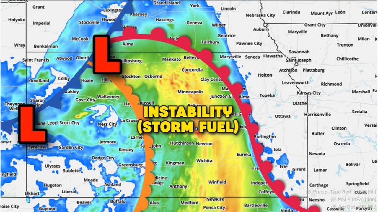
Current surface analysis shows a zone of meaningful instability — the atmospheric energy that powers thunderstorms — draped across central Kansas from near Salina and Hutchinson northward through Concordia and Mankato. This instability corridor sits between two surface low pressure centers positioned across western Kansas, with a warm front arcing eastward toward Kansas City and a dry line pushing in from the southwest.
The problem is what lies west of that instability zone. The surface from Garden City through Dodge City, Liberal, and Syracuse is classified as outright dry, with the central Kansas corridor sitting in a barely humid transition zone. Dewpoints are marginal at best. Without sufficient low-level moisture at the surface, storms struggle to initiate and sustain themselves even when the upper-level environment looks favorable.
Wind Shear Favors Supercells If Storms Can Fire
The one atmospheric ingredient working in today’s favor is the wind shear profile. Winds are changing both speed and direction with altitude across Kansas in a way that strongly favors supercell organization if storms can get started. Supercells in this environment would be capable of producing large hail as the primary threat, with tornado potential secondary depending on how the low-level moisture evolves through the afternoon.
The Missing Trigger Problem
A trigger is what forces air upward and breaks through the atmospheric cap to ignite thunderstorms. The most common triggers are frontal boundaries, dry lines, and outflow from existing storms. Current analysis shows the dry line and warm front are positioned across Kansas but neither is sharp or well-defined enough to confidently ignite storm development this afternoon. Without a stronger forcing mechanism, the instability and shear may simply sit unused as the day progresses.
| Ingredient | Status | Implication |
|---|---|---|
| Storm Instability | Present across central KS | Fuel available if storms fire |
| Wind Shear | Favorable for supercells | Large hail threat if storms develop |
| Surface Moisture | Dry to barely humid | Critical weakness in the setup |
| Atmospheric Trigger | Weak and uncertain | Storm initiation is the big question |
Forecast Confidence
Confidence in any severe weather across Kansas today is LOW to MODERATE and entirely conditional on whether a trigger can develop through the afternoon hours. If storms do initiate, confidence in supercell development with large hail is MODERATE to HIGH given the favorable shear profile. If the trigger fails to materialize, today becomes a non-event despite all the ingredients sitting in place.
Monitor afternoon updates closely. This forecast can flip in either direction quickly.
More severe weather coverage is always on the horizon. Stay informed at ChicagoMusicGuide.com — your source for Plains storm tracking and breaking severe weather coverage across Kansas and the entire United States.