Nebraska, Kansas and Oklahoma Face a Two-Day Severe Weather Outbreak Sunday and Monday With Strong Tornadoes, Giant Hail and Damaging Winds Possible
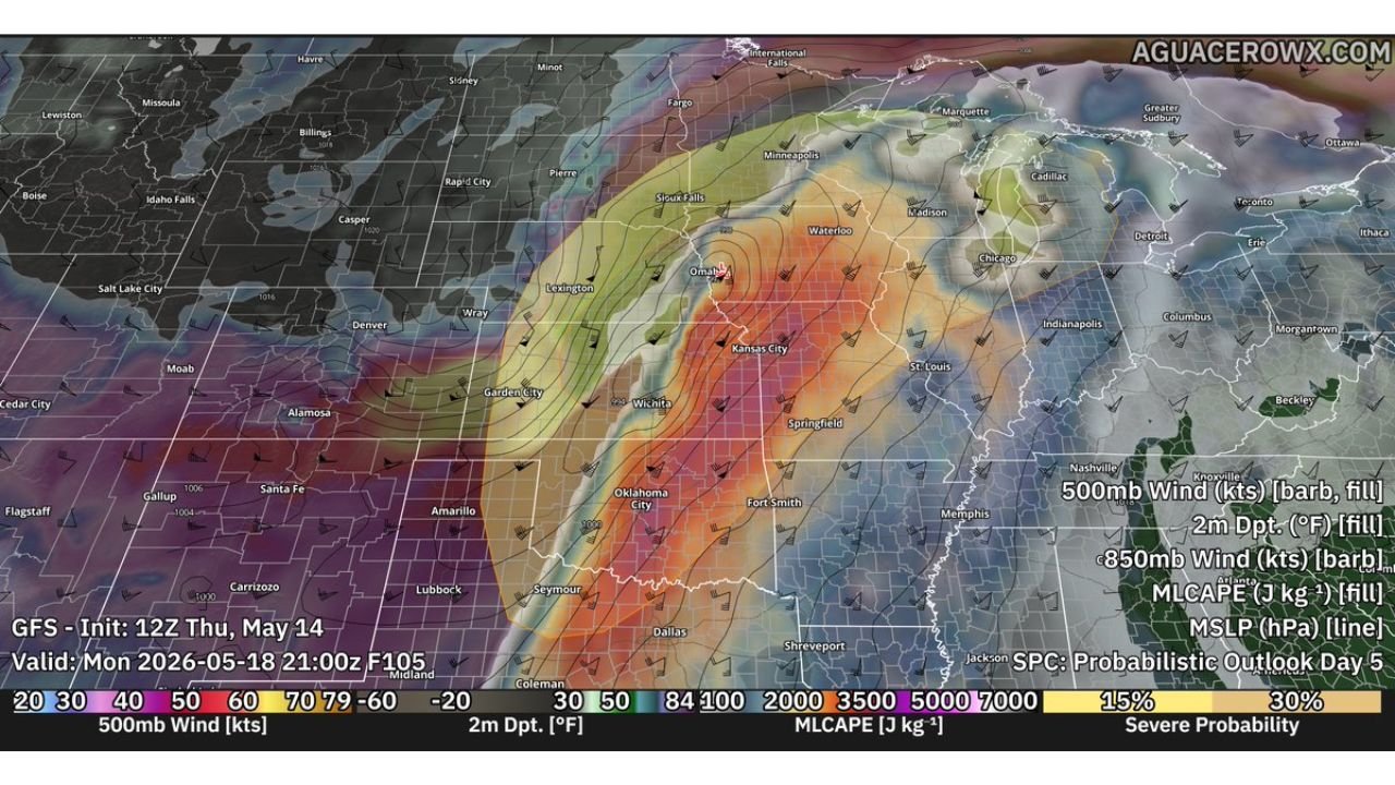
OMAHA, NE — A potentially significant two-day severe weather outbreak is taking shape for the central Plains and Midwest this weekend. Current model data initialized Thursday, May 14, 2026 shows a powerful upper-level trough swinging in from the west, delivering back-to-back dangerous severe weather days on Sunday, May 17 and Monday, May 18 across Nebraska, Kansas, Oklahoma, and adjacent states.
Sunday Brings Strong Tornado Threat Near the Triple Point
Sunday’s setup centers on an explosive combination of moisture and instability ahead of the approaching trough. Dewpoints are forecast to surge into the mid to upper 60s and lower 70s Fahrenheit across the risk zone, with Mixed-Layer CAPE — the atmospheric energy available to storms — reaching 3,000 to 4,000 joules per kilogram. That is an extremely volatile atmosphere.
A strong low-level jet stream pushing 40 to 50+ knots will provide the deep wind shear needed for supercell organization. All significant severe weather hazards are on the table for Sunday, but the strong tornado threat is the headline concern, particularly along or near the triple point where the cold front, warm front, and dry line intersect across Kansas and Nebraska.
Monday Trough Goes Negative Tilt and the Threat Intensifies
Monday brings no relief. The upper-level trough takes on a negative tilt as it pushes eastward, a configuration that increases atmospheric lift and typically produces the most intense severe weather setups. Current model data valid Monday, May 18 shows MLCAPE values of 5,000 to 7,000 joules per kilogram across the Oklahoma, Kansas, and Nebraska corridor — an extraordinary instability level.
Two storm modes are expected Monday. Discrete supercells firing along the dry line during the afternoon and evening will carry a hail and tornado threat. Those supercells may then merge into a fast-moving squall line during the evening and overnight, producing widespread damaging winds across a broad area of the Midwest.
Two-Day Threat Breakdown
| Day | Primary Threat Zone | Key Hazards | MLCAPE |
|---|---|---|---|
| Sunday May 17 | Kansas, Nebraska, triple point | Strong tornadoes, large hail | 3,000 to 4,000 J/kg |
| Monday May 18 | Oklahoma, Kansas, Nebraska, Midwest | Tornadoes, giant hail, damaging winds, squall line | 5,000 to 7,000 J/kg |
Cities Facing the Greatest Exposure This Weekend
Omaha, Kansas City, Wichita, Oklahoma City, and Sioux Falls all sit within the severe weather probability corridors shown in current model output for one or both days. The 30% severe probability zone on the Day 5 outlook is centered directly over the Omaha to Wichita corridor for Monday.
Forecast Confidence
Confidence in a significant two-day severe weather event across the central Plains is MODERATE and rising. The large-scale pattern is well-established across multiple model runs. Confidence in strong tornadoes Sunday near the triple point is MODERATE. Confidence in Monday’s explosive instability and dual storm mode scenario is MODERATE to HIGH. Specific track details will sharpen through Friday and Saturday.
Residents across Nebraska, Kansas, and Oklahoma should begin preparing severe weather plans now for both Sunday and Monday.
More severe weather coverage is always on the horizon. Stay informed at ChicagoMusicGuide.com — your source for outbreak tracking and breaking severe weather coverage across the Plains, Midwest, and the entire United States.