Indiana and Illinois Residents Face Tornado and Severe Storm Threat Today as Storm Rotation Values Hit Levels Seen Only a Few Times a Year
PEORIA, IL – A dangerous severe weather setup is unfolding across the eastern corn belt today, with storm rotation values climbing to levels that forecasters say only appear a few times a year. Illinois and Indiana are in the direct line of fire this afternoon and evening, and the tornado threat is real.
Why Today’s Setup Is Unusually Dangerous
Current analysis shows Storm Relative Helicity values over this region are extremely high. SRH, which measures a storm’s rotation potential relative to its motion, is running at levels that make it easy for supercell thunderstorms to spin up tornadoes quickly and without much warning. These numbers rank among the highest observed in this region on any given year, making today a significant severe weather event.
When SRH values reach this level, storms do not need to work hard to rotate. Supercells can develop tight circulations rapidly, and tornadoes can touch down with very little lead time for residents on the ground.
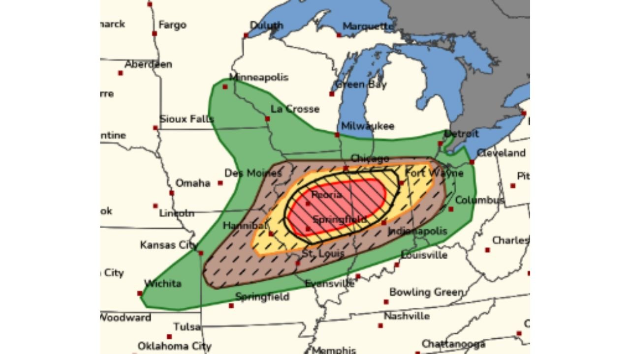
Where the Highest Risk Is Focused
Storm prediction data highlights a concentrated high risk zone centered near Peoria and Springfield, Illinois, extending eastward into Indiana toward Fort Wayne and Indianapolis. The hatched zone on current outlook maps, which indicates a significant tornado threat, covers a large portion of central Illinois and western Indiana.
| Risk Zone | Area Covered | Primary Threat |
|---|---|---|
| Highest Risk (Hatched) | Peoria, Springfield IL, western IN | Significant tornadoes |
| High Risk | Chicago south suburbs, Indianapolis | Tornadoes, large hail |
| Elevated Risk | Des Moines, St. Louis, Fort Wayne | Severe winds, tornadoes |
| Marginal Risk | Minneapolis, Kansas City, Nashville | Damaging winds |
County by County Alert Status
Illinois – Highest Threat Peoria, Tazewell, Sangamon, Logan, Mason and surrounding counties face the most significant tornado risk today and this evening.
Indiana – High Threat Marion, Tippecanoe, Vigo, Fountain, Warren and counties west of Indianapolis are under elevated tornado and severe storm risk through the evening hours.
Iowa and Missouri – Elevated Threat Des Moines and Hannibal area counties face severe storm potential with tornado risk included through the afternoon.
Wisconsin and Michigan – Marginal Threat Milwaukee, Green Bay and southern Michigan counties face a lower but nonzero severe weather risk later this evening as the system pushes northeast.
Forecast Confidence
Confidence in significant severe weather across central Illinois and western Indiana today is HIGH. The atmospheric ingredients are in place and storm rotation values are already at rare levels. Confidence in tornado production from storms this afternoon and evening is MODERATE to HIGH across the hatched risk zone. Storms firing this afternoon could move quickly and bring multiple threats including large hail, damaging winds, and tornadoes.
Do not wait for warnings to take action. Know your shelter location now before storms develop.
More severe weather coverage is always on the horizon. Stay informed at ChicagoMusicGuide.com – your source for breaking storm coverage across Illinois, Indiana, the Midwest, and the entire United States.