Strong Storm System Expected to Sweep Across Texas, Louisiana, Mississippi, and Alabama Next Thursday
UNITED STATES — Forecasters are tracking a powerful weather system expected to move from Texas through Louisiana, Mississippi, and Alabama late next week, bringing heavy rain, gusty winds, and possible severe thunderstorms as it pushes east.
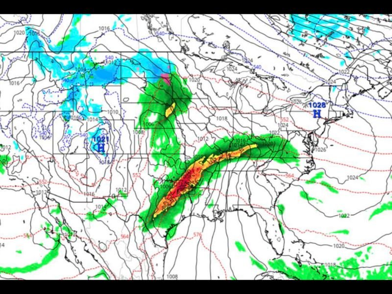
Meteorologists say the system could arrive by Thursday, setting up a “cold front meets Gulf moisture” scenario that often fuels strong storms across the southern states this time of year.
Heavy Rain and Gusty Winds Expected
According to early forecasts, a long line of organized storms is projected to form over Texas and sweep eastward across the lower Gulf states. While details could still shift, forecasters say conditions appear favorable for:
- Heavy downpours along the cold front
- Strong wind gusts ahead of the system
- Possible thunderstorm activity, with rumbles that could wake residents overnight
- Cooler, drier air arriving immediately after the front passes
“This setup has all the ingredients of a classic late-autumn system,” meteorologists explained. “Warm Gulf air will clash with a cold front dropping out of the Plains — and that’s a recipe for strong thunderstorms and widespread rain.”
Timing and Intensity May Still Shift
The projected timing places the most significant weather between Wednesday night and Thursday, though forecasters note that both storm strength and movement could still change as new model data arrives.
Residents in Houston, New Orleans, Jackson, and Birmingham are advised to monitor forecasts closely and prepare for possible outdoor disruptions or travel delays late next week.
“Anyone planning events or outdoor travel should start considering backup plans,” forecasters said, adding that it’s better to “expect messy conditions than be caught by surprise.”
Cooler, Drier Air to Follow the Front
Once the front clears, temperatures are expected to drop significantly across the South, with cool, dry air replacing the humid Gulf warmth that’s dominated much of November.
Meteorologists say the cooldown will be a welcome change for many but caution that it may come only after a round of strong storms.
“This looks like one of those systems that slams the door on fall warmth,” one forecaster said. “Once it passes, expect crisp mornings and the first real taste of early winter for much of the region.”
Stay Prepared and Stay Updated
While it’s still early, forecasters emphasize the importance of keeping up with local alerts as the system approaches. If trends continue, portions of eastern Texas through Alabama could see isolated severe weather, including damaging winds or brief tornadoes.
Residents are urged to:
- Secure outdoor items ahead of the front
- Be alert for weather advisories or watches mid-week
- Avoid travel during periods of heavy rain and lightning
Chicago Music Guide will continue to monitor the evolving system and provide updates as the forecast becomes more precise.