Midwest Winter Storm to Bring Snow, Sleet, and Ice From Arkansas to Ohio, Creating Dangerous Travel Conditions Through Tuesday Morning
CHICAGO, ILLINOIS — A fast-moving winter storm is sweeping across the Midwest on Monday, spreading snow, sleet, and pockets of freezing rain from Arkansas to Ohio and leading to rapidly deteriorating road conditions. With more snow expected overnight, much of the region is preparing for a hazardous commute on Tuesday morning.
Winter Weather Advisories Stretch Across Several States
The National Weather Service has issued Winter Weather Advisories across portions of Arkansas, Illinois, Indiana, and Ohio, warning of dangerous travel as the storm continues its northeast path.
- Northern Arkansas: Light ice accumulations up to one-tenth of an inch, enough to glaze roads, bridges, and power lines.
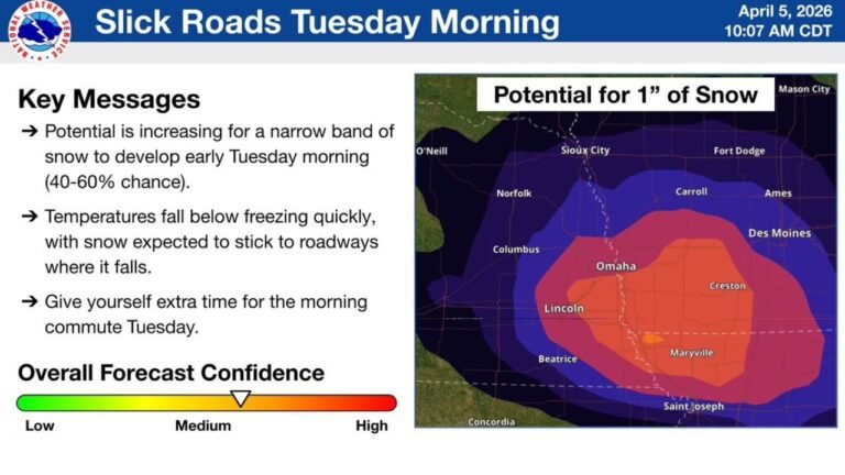
- Illinois and Indiana: Forecasts call for 2 to 5 inches of snow, with the highest totals likely in areas south of Interstate 80.
- Southern and Central Midwest: Sleet may mix in at times, increasing the risk of icy spots.
Forecasters say heavier snow bands may develop in northern and central Illinois this evening, potentially producing near-whiteout conditions.
Ohio Braces for Heaviest Snow Early Tuesday
In Ohio, snow is expected to begin overnight, with the heaviest falling between 4 a.m. and 9 a.m. Tuesday. Major cities including Cleveland, Canton, and Akron are expected to see slow-moving traffic and slick roads during the busiest hours of the morning commute.
Key travel corridors such as I-55, I-70, and I-75 may experience icy bridges, reduced visibility, and fast-accumulating snow.
Hazardous Travel Conditions Likely Regionwide
Motorists across the Midwest should anticipate:
- Slippery interstates and rural roads
- Reduced visibility during bursts of heavy snow
- Icy bridges and overpasses
- Longer travel times during both commutes
Drivers are urged to slow down, leave extra space between vehicles, and check official state road condition maps before heading out.
Storm Moves East by Tuesday Afternoon
The winter storm is expected to continue moving east through Tuesday afternoon, leaving behind colder air and pockets of scattered snow showers into midweek. Even after the main system departs, untreated surfaces and shaded areas could remain icy due to persistent low temperatures.
For ongoing coverage of winter weather alerts and how storms impact travel, concerts, and events across the region, stay connected with ChicagoMusicGuide.com.