Minnesota Braces for Dangerous Arctic Outbreak as Temperatures Plunge 25–40 Degrees Below Normal This Weekend
MINNESOTA — A powerful Arctic blast is on track to drive temperatures 25–40 degrees below normal this weekend, creating one of the coldest mid-December outbreaks the state has seen in years.
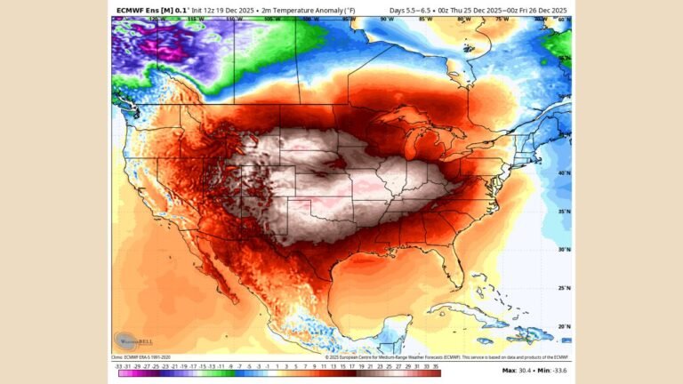
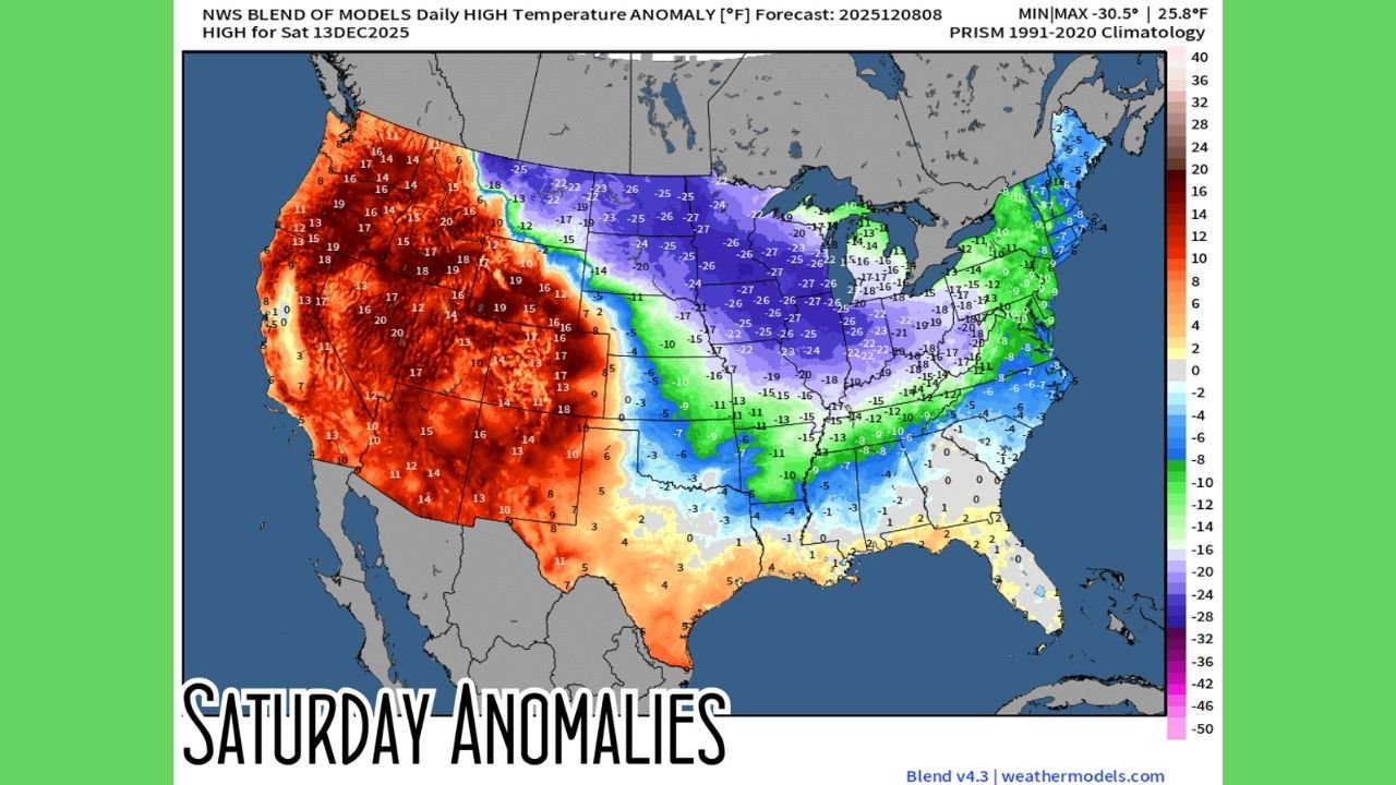
Forecast models show a broad zone of extreme negative temperature anomalies stretching across Minnesota early Saturday morning, with some locations projected to experience readings between –20°F and –40°F below typical averages for this time of year. This surge of bitter air is part of a deepening trough diving south from Canada, bringing widespread subzero conditions and potentially dangerous wind chills.
The latest GFS and NWS blend of model guidance highlight Minnesota as the core impact zone in the northern United States, with the state positioned beneath the coldest atmospheric profile of the entire Arctic plunge.
Record-Breaking Cold Possible as Arctic Air Expands Across the Upper Midwest
Meteorologists note that temperature anomalies of –30°F to –40°F are rare even in midwinter, and seeing values of this magnitude in mid-December raises the risk of record lows being challenged or broken.
The early-morning forecast maps show:
- Large portions of central and northern Minnesota falling 30–40°F below normal
- Subzero morning lows widespread across the region
- Wind chill values diving far below zero, especially in rural and open areas
- Surrounding states like Wisconsin, Iowa, and the Dakotas experiencing notable cold, but Minnesota holding the most extreme anomalies
These conditions come amid growing online discussion about an “Arctic outbreak” sweeping the country, with weather analysts noting that the atmosphere is producing one of the strongest cold fronts of the season.
What Saturday’s Temperature Anomalies Reveal
Model blends for Saturday, December 13 show a dramatic contrast across the nation:
- The West Coast and Southwest are running 10–20°F above average
- The Deep South remains near normal
- The Central and Northern Plains, especially Minnesota, show widespread anomalies of –20°F to –40°F
This pattern underscores how sharply the Arctic air mass has carved into the Midwest while bypassing much of the southern U.S.
Graphics from pivotalweather.com highlight Minnesota’s bullseye zone of deep purple and white shading—indicating the coldest departures from normal anywhere in the country.
Travel, School, and Outdoor Safety Concerns
Residents across Minnesota should prepare for:
- Hazardous travel, especially during overnight freezes
- Elevated risk of frostbite with wind chills below –25°F
- Strain on home heating systems, particularly in older buildings
- Potential delays or modifications to outdoor events and school activities
Officials urge residents to check on vulnerable neighbors, ensure pets are sheltered, and limit unnecessary early-morning travel when temperatures will be most severe.
Looking Ahead
While temperatures are expected to gradually moderate after the weekend, Minnesota will remain in a colder-than-average pattern heading into the following week. Meteorologists advise residents to stay updated as more refined forecasts and advisories are issued by the National Weather Service.
Thanks for reading today’s weather breakdown on ChicagoMusicGuide.com. Stay tuned for more regional updates and forecasts as the Arctic pattern continues to unfold.