Illinois and the Northern U.S. Expected to See Repeated Alberta Clippers Bringing Light to Moderate Snow Through Late December
ILLINOIS — A New Long-Range Pattern Sets Up a Busy Snow Track Across the Northern States, A new two-week precipitation outlook shows a sharply divided weather pattern across the country, placing Illinois and the broader northern United States directly in the path of repeated Alberta clipper systems. These fast-moving storms, known for delivering bursts of snow and reinforcing cold air, are expected to track across the region from now through December 23, 2025.
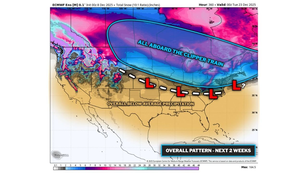
Forecast imagery highlights a broad cold corridor stretching from the northern Rockies across the Midwest and into the Northeast — a zone labeled “All Aboard the Clipper Train.” Illinois sits squarely inside this active band, signaling multiple opportunities for light to moderate snowfall, quick temperature drops, and blustery conditions.
Meanwhile, the southern half of the U.S. is projected to remain much drier, especially across the Southwest, where precipitation is forecast to fall well below normal levels.
Clipper Systems to Drive Frequent Snowfall Across Northern Illinois
The ECMWF ensemble model shows a series of storm systems diving southeast from Canada, each bringing brief but impactful rounds of snow. Key expectations for Illinois include:
- Multiple light to moderate snow events over the next two weeks
- Sharp, repeated cold blasts behind each clipper
- Potential for enhanced snowfall if a clipper taps into southern stream energy
- Gusty winds that could reduce visibility, especially in open areas
- Cumulative travel impacts, even if each individual system is small
While Alberta clippers usually carry limited moisture, their frequency can make the pattern quite active — particularly for northern Illinois and the Chicago region.
Southern States Enter a Mostly Dry Pattern
Forecast maps show widespread below-average precipitation stretching from the Southwest across Texas, Oklahoma, and the Gulf Coast. The southern jet stream appears weaker during this period, limiting large-scale storm development.
However, occasional southern stream disturbances may bring isolated light to moderate rain to the mid-South and parts of the Ohio Valley. These events are expected to be scattered and less significant than the northern snow pattern.
Holiday Travel Could Be Affected in Illinois
As December progresses, Illinois residents — especially in northern counties — should expect:
- Periodic bursts of snow
- Reduced visibility during fast-moving clippers
- Potential slick roadways around commute hours
- Increasingly colder temperatures heading into Christmas week
The combination of frequent disturbances and wind-driven cold may create occasional travel delays, even when snow totals remain modest.
What to Watch in the Days Ahead
With several clippers already identified in model guidance, residents should monitor updated forecasts as timing and intensity can shift quickly with this type of pattern. Northern Illinois is expected to remain active, while the southern U.S. stays comparatively quiet.
Stay connected with ChicagoMusicGuide.com for more winter weather updates, Illinois forecasts, and local coverage throughout the season.