Minnesota, Iowa, South Dakota, and Illinois Expected to Face Dangerous 50–70 mph Wind Gusts Likely to Create Ground Blizzard Conditions
MIDWEST — A High-Impact Wind Event Threatens Widespread Ground Blizzard Conditions Across Four States, A powerful and fast-developing wind event is expected to sweep across the central United States beginning Wednesday, bringing dangerous 50–70 mph wind gusts to Minnesota, Iowa, South Dakota, and Illinois. Meteorologists warn that the combination of these extreme winds and the existing snowpack may produce ground blizzard conditions — a hazardous weather scenario capable of creating sudden whiteouts and dangerously low visibility without any new snowfall.
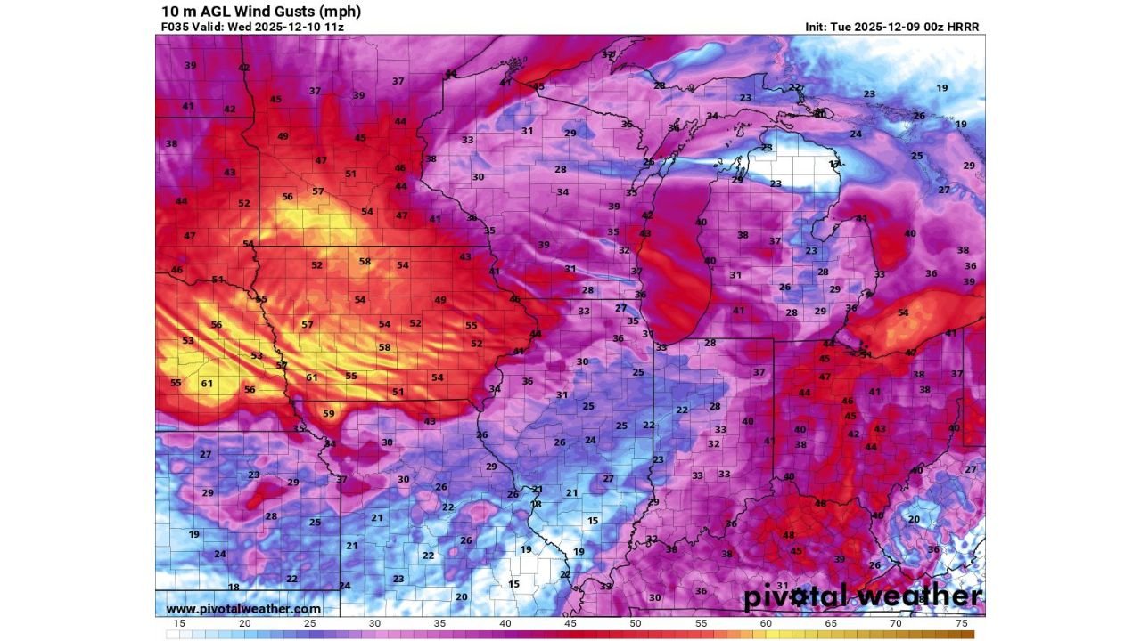
HRRR model data analyzed for this forecast shows a large corridor of intense winds stretching from the Dakotas across the Upper Midwest and into the Great Lakes region, marking one of the most widespread high-wind events so far this season.
With gusts approaching 70 mph in parts of Iowa and South Dakota, and 50–55 mph common across Minnesota and Illinois, travel conditions may deteriorate rapidly, especially in open rural areas.
Why Ground Blizzards Are So Dangerous — Even With Clear Skies
This event is especially concerning because no new snow is required to create life-threatening travel conditions. Strong winds can lift the snow already on the ground into the air, generating:
- Blinding whiteouts within seconds
- Near-zero visibility over long stretches of road
- Hazardous drifting and rapidly forming snowbanks
- Roadway closures and major travel delays
- Situations where drivers cannot see beyond their headlights
Unlike a traditional snowstorm, ground blizzards can strike unexpectedly, catching travelers and commuters off guard.
A Closer Look at the State-by-State Impact
South Dakota
- Widespread gusts of 60–70 mph, strongest in the eastern half
- High risk for open-country whiteouts and drifted rural roads
- Potential for structural stress, tree damage, and blowing debris
Minnesota
- Gusts commonly ranging 45–60 mph, strongest in the southern region
- Snowpack in southern and western Minnesota makes blowing snow highly likely
- Travel along I-35 and I-90 could be significantly affected
Iowa
- One of the highest-impact zones, with 58–70 mph gusts across central and western counties
- Maps show broad red and yellow regions indicating extreme wind potential
- Expect dangerous ground blizzard setups on rural highways, including I-80 and I-35
Illinois
- Northern and western Illinois may see gusts of 45–55 mph, with localized higher peaks
- Wind intensity may be strong enough to lift loose snow and severely reduce visibility
- Travel issues expected especially in areas with open fields and minimal tree cover
These projections highlight a regional event — not a localized one — with multiple states facing simultaneous hazards.
Timing and Expected Conditions
The most intense winds are forecast for Wednesday morning through early afternoon, though some areas may see elevated gusts even earlier.
During peak hours, residents across the four-state region should expect:
- Rapidly worsening visibility
- Sudden ground-level whiteouts
- Blowing snow drifting across major highways
- Strong crosswinds impacting high-profile vehicles
- Possible cancellation or delay of flights
Emergency managers urge residents in all affected states to avoid unnecessary travel during peak wind periods.
What Residents Across the Midwest Should Do
Authorities recommend:
- Monitoring real-time conditions before traveling
- Keeping emergency supplies in vehicles
- Preparing for potential delays, detours, or road closures
- Avoiding open rural routes during the highest wind-gust periods
Because ground blizzards form quickly and unpredictably, conditions may shift dramatically from one mile to the next.
A Significant Early-Winter Threat Across the Heartland
This multi-state wind event underscores how dangerous winter conditions can become even without a fresh snowfall. With wind gusts approaching 70 mph and an existing snowpack in place, millions across Minnesota, Iowa, South Dakota, and Illinois may face serious travel hazards tomorrow.
Stay updated with ChicagoMusicGuide.com for continuing Midwest weather coverage, safety information, and breaking developments.