Winter Storm Expected to Impact Tennessee, North Carolina, Kentucky, and West Virginia as Strengthening System Brings Snow and Rapid Temperature Drop
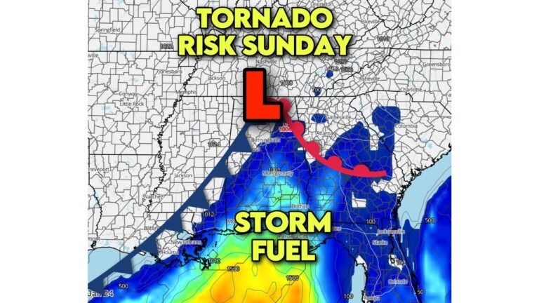
TENNESSEE — Southeast Appalachian Region Braces for Snow and Bitter Cold as Weekend Storm Intensifies, A developing winter storm is expected to move across the Southeast Appalachian region this Sunday, bringing the risk of accumulating snow, hazardous travel, and a sharp plunge in temperatures across Tennessee, North Carolina, Kentucky, and West Virginia.
The system, which has been showing signs of strengthening, may deliver one of the coldest early-December outbreaks the region has experienced in recent years.
Snow, freezing temperatures, and dangerous wind chills are all possible as the storm pushes east and colder air rushes in behind it.
Snow Likely Across Higher Elevations, With Lower Elevations Also at Risk
Forecast trends show that the storm will pull enough moisture and cold air into the region to produce widespread wintry weather, particularly in the Appalachian Mountains and foothills.
Expected Impacts Include:
- Accumulating snow in higher elevations of Tennessee, North Carolina, Kentucky, and West Virginia
- Slick roads and reduced visibility during heavier snow periods
- Lighter accumulations still possible in lower elevations
- Potential travel delays Sunday afternoon and evening
Mountain communities may see the most significant snowfall, while lower valleys and city centers may experience a mix transitioning to snow as colder air arrives.
Sharp Temperature Drop Expected Immediately After Snow Ends
One of the most significant hazards comes after the storm moves out.
A surge of Arctic air is expected to sweep across the Southeast Appalachians Sunday night into Monday.
Temperatures may fall:
- Into the teens across much of Tennessee and Kentucky
- Into the single digits in higher elevations of North Carolina and West Virginia
- Below zero wind chills in exposed mountain areas
Any melted snow or wet pavement will quickly freeze, creating hazardous conditions for the Monday morning commute.
Tennessee: Snow and Quick Freeze Possible
In Tennessee, the most affected areas are expected to be:
- Eastern Tennessee, where snow is most likely
- Communities near the Smoky Mountains, where totals may be higher
- Urban areas like Knoxville and Johnson City may see slick roads
Temperatures are forecast to plunge Sunday night, intensifying icy conditions.
North Carolina: Mountains and Foothills Face Significant Winter Impacts
Western North Carolina is positioned for some of the strongest effects, including:
- Accumulating snow in the Blue Ridge and surrounding mountains
- Difficult travel on mountain passes
- Rapid temperature drop leading to icy roads into Monday
Lower elevations, including Asheville and nearby areas, may also see measurable snowfall.
Kentucky: Snow Risk Extends From Central to Eastern Counties
Kentucky may experience:
- Snow showers across eastern and central regions
- Hazardous travel conditions Sunday night
- Temperatures dropping to the teens, with single digits in higher terrain
Icy conditions are possible across widespread areas Monday morning.
West Virginia: Heaviest Snow Potential in Higher Terrain
West Virginia could see some of the most significant impacts in the region:
- Snow is likely across much of the state
- Mountainous areas may see several inches
- Travel may become difficult in higher elevations
- Temperatures Sunday night may fall into the single digits
Colder air will linger into early next week.
Cold Wave Expected to Persist Into Early Week
After the storm exits, the entire Southeast Appalachian region will remain under below-normal temperatures, with limited daytime warming and widespread freezing conditions.
Residents should prepare for:
- Extended cold
- Possible power strain
- Refreezing of wet surfaces
- Delays to school or work travel
Residents Urged to Prepare for a High-Impact Winter Weekend
Authorities advise Southeast Appalachian residents to plan ahead for:
- Possible snowy and icy roads
- Bitter nighttime cold
- Reduced visibility in mountain passes
- Travel disruptions
Precautions such as insulating pipes, limiting outdoor exposure, and allowing extra travel time are recommended.
Stay Updated With ChicagoMusicGuide.com
ChicagoMusicGuide.com will continue to track developing conditions across Tennessee, North Carolina, Kentucky, and West Virginia as more information becomes available.