Illinois, Iowa, Missouri, Indiana, and Ohio Brace for Dangerous Arctic Blast With Temperatures 30–35 Degrees Below Normal Tonight
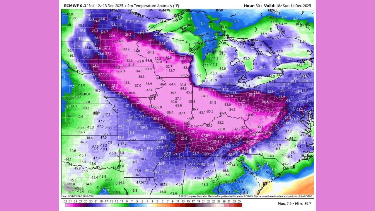
CHICAGO, Illinois — A powerful Arctic Blast is set to slam the Midwest and Ohio Valley tonight, delivering some of the most extreme temperature departures of the season. New ECMWF model data shows temperatures running 30 to 35 degrees below average, with wind chills plunging well below zero across a massive stretch of the central United States.
This unusually strong cold outbreak will put Illinois, Iowa, Missouri, Indiana, and Ohio directly in the core of its impact zone, creating hazardous conditions for anyone spending time outdoors.
Arctic Air Surges South, Sending Temperatures Into the Single Digits
Model guidance for Sunday evening reveals a dramatic drop in temperatures across the Midwest, with much of the region falling into the single digits and pockets of below-zero readings.
The ECMWF temperature anomaly chart shows a large swath of deep purples and pinks — the classic signature of a strong Arctic intrusion.
Areas in the heart of the Midwest, including central Illinois, eastern Iowa, northern Missouri, and western Indiana, are projected to experience the most extreme departures, some nearing –35°F below climatological norms.
For context, these departures are typically associated with mid-winter cold snaps — not early December.
Wind Chills Could Reach Dangerous Levels Overnight
Meteorologists warn that wind chills may drop into the –10° to –25° range, depending on location and local wind gusts.
This creates conditions where frostbite can occur in as little as 15–20 minutes on exposed skin.
Residents in Illinois and Iowa should be especially cautious, as they fall directly within the deepest pocket of anomalous cold shown on the ECMWF model.
Even large metropolitan areas like Chicago, Indianapolis, St. Louis, Des Moines, and Columbus will feel the brunt of this blast.
Why This Cold Is So Extreme for Mid-December
Typically, early December brings chilly weather but not the kind of Arctic intensity seen tonight. The ECMWF map shows an unusually steep pressure gradient and strong northerly flow, funneling cold air straight from central Canada.
This setup allows:
- Rapid temperature drops after sunset
- High winds enhancing the chill factor
- Nearly 20 states experiencing significantly below-average temperatures
By late tonight and early Monday, the core of the Arctic air mass will expand further east, eventually reaching the Mid-Atlantic.
What Residents Should Do
Meteorologists advise residents across all impacted states to take precautions:
- Limit time outdoors, especially for children and the elderly
- Wear multiple layers, hats, gloves, and scarves
- Bring pets indoors
- Check on neighbors who may struggle with heating
- Prepare for possible heating system strain during the coldest hours
A Brutal Reminder of Early Winter’s Power
Even though the season is just beginning, this Arctic Blast serves as a powerful reminder of how quickly winter can turn dangerous across the Midwest. With temperatures plunging 30–35 degrees below the seasonal average, tonight’s cold presents a real health and safety risk for millions.
Stay bundled up, stay alert, and stay safe.
What’s the weather like in your area tonight? Share your updates and photos with us at ChicagoMusicGuide.com.