Powerful Wind Storm Expected to Hit Long Island, New York Friday Morning, Raising Risk of Widespread Power Outages
NEW YORK — A High-Impact Wind Event Will Target Long Island Friday Morning, A significant wind storm is expected to sweep across Long Island, New York, on Friday, bringing damaging wind gusts between 60 and 75 mph, according to new high-resolution model data. The strongest winds are projected to occur between 7 a.m. and 1 p.m., raising legitimate concerns for power outages, fallen tree limbs, and hazardous travel conditions across Nassau and Suffolk counties.
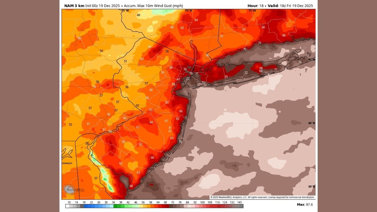
Forecast guidance from both the HRRR and NAM 3 km models shows a concentrated corridor of intense gust potential directly over the island, especially along the South Shore and East End, where the highest gusts appear most likely.
Wind Models Show Widespread 60–70+ MPH Gusts Across Long Island
Model comparisons highlight a consistent threat across sources:
- HRRR (Hour 29) shows gusts 65–70 mph hugging the Long Island coastline.
- NAM 3 km (Hour 18) displays even higher gust potential, with pockets of 70–75 mph along the shoreline.
- Interior Long Island sees gusts between 55 and 65 mph, still strong enough to damage weak structures and down trees.
Surrounding regions—including New Jersey, coastal Connecticut, and parts of New York City—will also see elevated winds, but Long Island sits in the bullseye for the strongest impacts.
Power Outages Likely as the Core of the Storm Passes
With wind gusts exceeding 60 mph, the risk for power outages becomes substantial. Long Island’s heavily treed neighborhoods and overhead utility grid make the region especially vulnerable during strong wind events.
Residents should prepare for:
- Downed power lines
- Tree damage
- Hazardous morning travel
- Possible delays for ferries, railways, and flights
The timing of the strongest winds—during the morning commute—adds further concern for safety.
Timing: 7 A.M. to 1 P.M. Is the Primary Window of Impact
Both model animations show a rapid increase in wind speeds during the early morning. The peak wind period occurs:
- Begins: ~7:00 a.m.
- Peak: 8:30 a.m. – 12:00 p.m.
- Weakening: After 1:00 p.m.
Residents are urged to secure outdoor objects—holiday decorations, trash bins, lightweight furniture—as these may become airborne hazards.
Rainfall and Coastal Impacts
Although this event is primarily a wind storm, localized heavy rain bands may accompany the strongest gusts. Combine this with high winds, and brief reductions in visibility are possible.
Coastal flooding threats appear limited based on current guidance, but strong onshore winds may still cause minor water level rises on vulnerable south-facing shores.
What Residents Should Do Now
- Charge phones and backup power devices tonight.
- Avoid parking vehicles near large trees.
- Plan for possible morning travel delays.
- Prepare for outages lasting several hours in some communities.
More updates will be issued as new data arrives, and residents should follow local National Weather Service alerts closely.
Stay Connected With ChicagoMusicGuide.com
For ongoing weather updates, storm tracking, and breaking alerts, keep checking ChicagoMusicGuide.com as the situation evolves.