California, Oregon, and Washington Face One of the Hottest Decembers on Record as Western Snowpack Collapses
SEATTLE, WASHINGTON — Large portions of the Western United States are experiencing one of the warmest Decembers on record, as persistent high-pressure ridging has driven temperatures well above seasonal averages across the region over the past two weeks, according to long-range temperature analysis and percentile data.
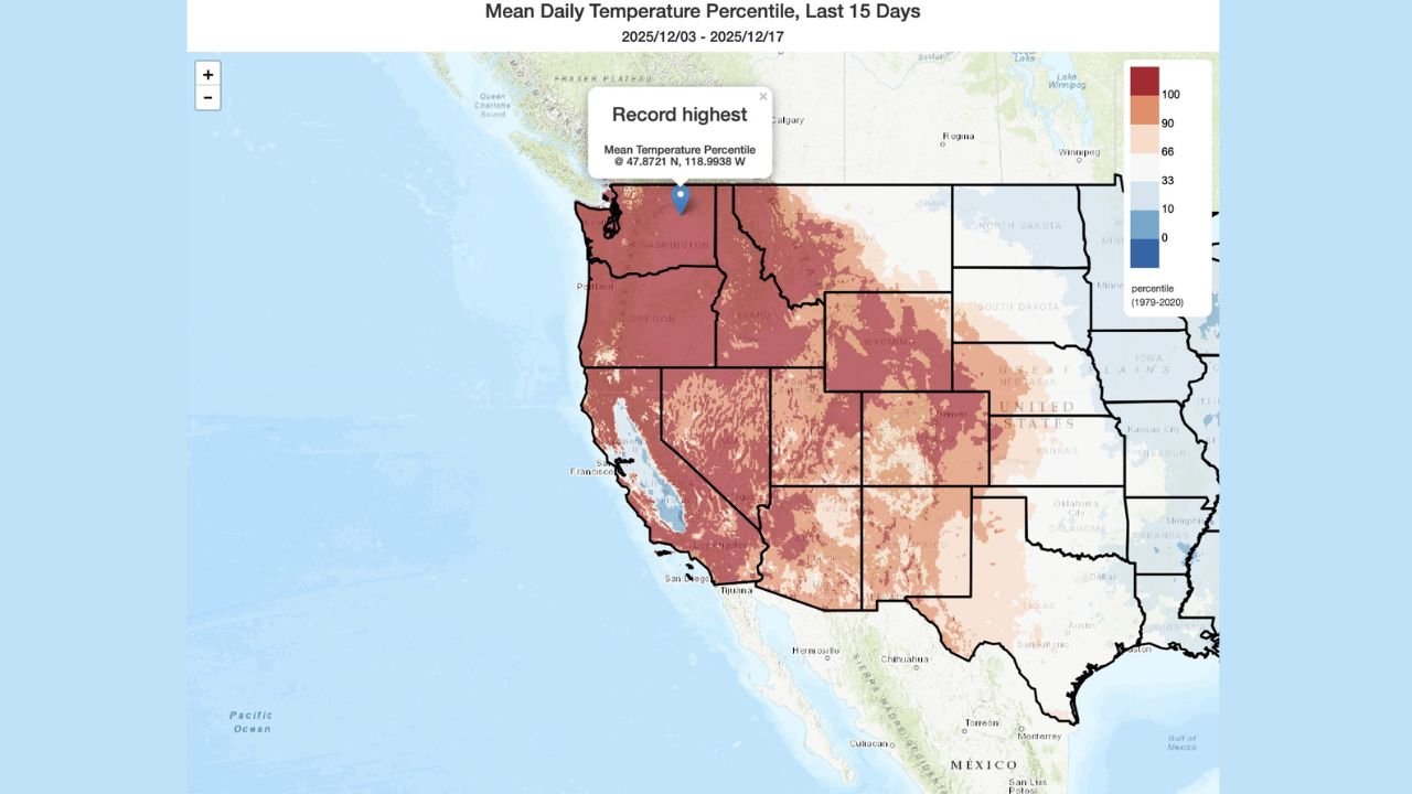
Meteorological data shows widespread areas from Washington, Oregon, California, Idaho, Nevada, Utah, Arizona, and parts of the Rocky Mountain region running at or near record-high temperature percentiles, with some locations ranking in the top 1 percent of warmth for mid-December.
“This level of warmth for this long, especially in December, is highly unusual and historically significant.”
Western States See Widespread Record-High Temperature Percentiles
Temperature percentile maps covering the last 15 days show dark red shading across much of the West, indicating record-warm daily mean temperatures relative to historical norms.
Key highlights include:
- Pacific Northwest: Parts of Washington and Oregon have averaged 15–20°F above normal
- California: Persistent warmth from Northern California through Southern California
- Interior West: Idaho, Nevada, Utah, and western Montana experiencing near-record warmth
- Southwest: Arizona and New Mexico continuing above-average temperature trends
Several locations reached the highest mean temperature percentile ever recorded for this time of year.
“Unseasonable and Persistent”: Why This Warm Pattern Is Unusual
Meteorologists attribute the abnormal warmth to a strong, stationary ridge of high pressure anchored over the western half of North America.
This atmospheric setup has:
- Blocked cold Arctic air from moving south
- Reduced storm activity across the region
- Allowed mild Pacific air to dominate for weeks
“This is not a short-term warm spell — it’s a sustained pattern that’s rewriting December climate expectations.”
Unlike typical winter variability, this pattern has shown remarkable persistence, extending well into mid-December without meaningful cooling.
Snowpack Drops to Lowest Mid-December Levels in Decades
One of the most concerning impacts of the prolonged warmth has been the dramatic reduction in mountain snowpack.
According to regional snow and climate monitoring:
- Sierra Nevada: Snowpack far below seasonal averages
- Cascade Range: Some of the smallest mid-December snow totals in decades
- Rocky Mountains: Delayed snow accumulation across multiple basins
Experts note this could have long-term implications for water supply, wildfire risk, and spring runoff.
“This may be the smallest mid-December snowpack the West has seen in generations.”
What Comes Next: Can Winter Still Recover?
While winter is far from over, climatologists caution that catching up on snowpack becomes harder the longer warmth persists.
Potential impacts if the pattern continues include:
- Increased drought concerns heading into spring
- Reduced hydroelectric capacity
- Elevated wildfire risk later in 2026
- Strain on ecosystems dependent on snowmelt
Forecasters are monitoring whether upcoming pattern shifts could finally allow colder air and Pacific storms to return before the end of the year.
Why This December Matters
This event is more than just a warm holiday stretch — it represents a significant climate signal, reinforcing long-term warming trends and highlighting the increasing frequency of record-breaking winter warmth across the Western United States.
“December is traditionally a cornerstone of winter snow buildup — losing that foundation changes everything downstream.”
If you live in the Western U.S., how has this unusual December warmth affected your area — snow, travel, or daily life? Share your experience and stay updated with ongoing weather coverage at ChicagoMusicGuide.com.