New England Snowstorm Forecast Brings Snow-to-Rain Transition Across Massachusetts, New Hampshire, and Maine Early Tuesday
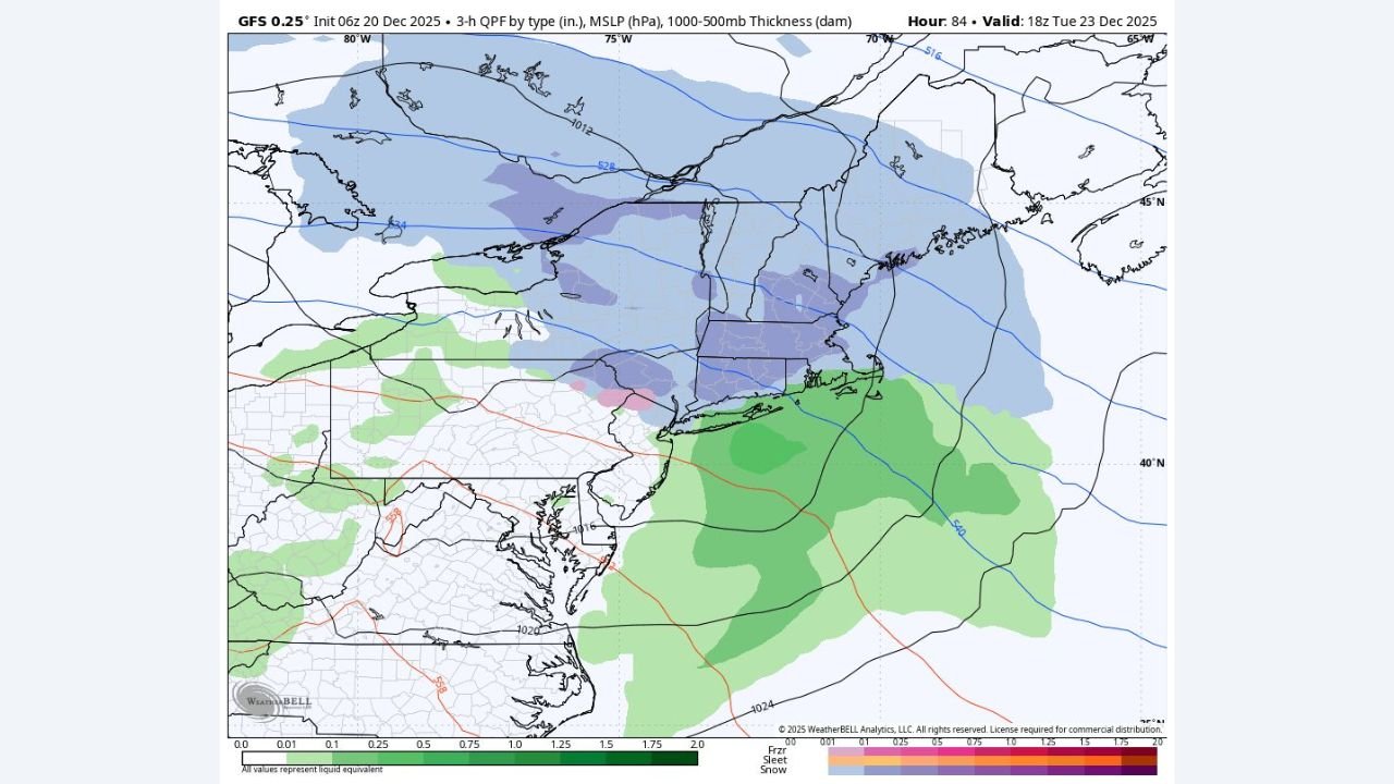
BOSTON, MASSACHUSETTS — A developing winter weather system is expected to move across Massachusetts, New Hampshire, and Maine early Tuesday morning, bringing a period of accumulating snow inland before changing to rain near the coastline, according to the latest forecast model guidance.
Forecasters say snow will overspread much of the region before daybreak Tuesday, with colder inland areas seeing the highest likelihood of accumulation, while coastal communities may experience a quicker transition to rain as milder air pushes northward from the Atlantic.
Snow Expected to Develop Early Tuesday Morning
Model data shows snow breaking out from southwest to northeast across New England, including central and western Massachusetts, interior New Hampshire, and much of Maine. While snowfall totals are still being refined, a couple inches of accumulation remain possible, especially away from the immediate coastline.
“Snow is likely to develop statewide early Tuesday, with a gradual changeover to rain near the shore.”
Road conditions could become slick during the morning commute, particularly in inland communities where surface temperatures remain colder.
Rain Likely Along the Coastline
As the system strengthens offshore, warmer marine air is expected to push inland, causing snow to mix with and change to rain along coastal Massachusetts and southern Maine. This transition may limit snowfall totals near the shoreline but could still create brief periods of slushy accumulation before the changeover.
Coastal impacts are expected to be less severe overall, though reduced visibility and wet roadways could still affect travel.
Where Accumulation Is Most Likely
The highest chance for measurable snowfall appears focused on:
- Interior Massachusetts
- Central and northern New Hampshire
- Much of inland Maine
These areas may hold onto snow longer before any mixing occurs, increasing the likelihood of light to moderate accumulations.
Forecast Confidence Still Evolving
Meteorologists caution that small changes in storm track or temperature profiles could significantly affect snowfall totals and the timing of the rain transition. Forecasters say they will continue monitoring updates as higher-resolution models come into range.
“We’ll be keeping a close eye on this system as details become clearer.”
What to Know Right Now
- Snow develops early Tuesday morning
- Rain likely near the coast
- A few inches of snow possible inland
- Morning travel impacts possible
Residents across New England are encouraged to stay alert for updated forecasts and potential advisories as the system approaches.
If you’re heading to a show, rehearsal, or event this week, plan for changing travel conditions and allow extra time Tuesday morning.
For continued weather updates affecting concerts, travel, and regional events, keep checking back with ChicagoMusicGuide.com.