California Storm Brings Flood Watches to the North Bay as Heavy Rain and 45-MPH Winds Impact the Bay Area
CALIFORNIA — A powerful Pacific storm system is moving through Northern California, placing the North Bay under flood watches as heavy rainfall, rising creeks, and gusty winds up to 45 mph impact the broader Bay Area. Forecasters warn that the combination of saturated ground and incoming rain could quickly lead to localized flooding, particularly in areas prone to poor drainage and fast-rising waterways.
North Bay Faces Highest Flood Risk
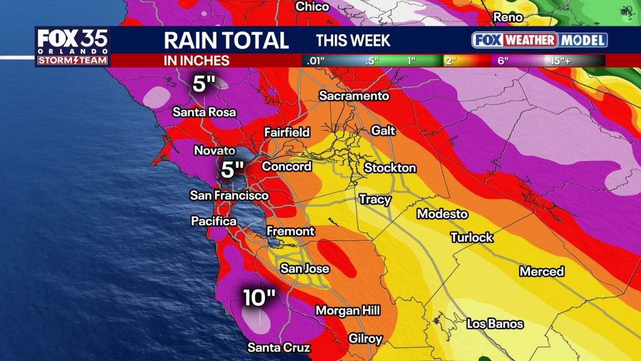
The North Bay remains the most impacted region, with flood watches in effect through Monday afternoon. Rainfall totals are expected to be highest across Sonoma, Napa, and Marin counties, where multiple inches of rain could fall in a short period of time. Officials caution that smaller streams and creeks may reach flood stage, especially during heavier downpours.
River forecast data shows Mark West Creek near Mirabel Heights and Santa Rosa Creek rising above monitor levels, with projections indicating the potential to reach or briefly exceed flood stage if rainfall intensifies. Low-lying roads, underpasses, and creek-adjacent neighborhoods may see water accumulation with little warning.
Bay Area Rainfall Varies Due to Terrain
Rainfall amounts will not be uniform across the region. The storm’s southwesterly flow favors coastal hills and the North Bay mountains, where totals could exceed 4 to 6 inches. In contrast, rain shadowing is expected in parts of the South Bay, where downslope winds reduce rainfall totals in valley locations.
Despite lower totals in some inland areas, urban flooding remains a concern due to clogged storm drains and intense short-duration rain rates, particularly during peak rainfall windows.
Strong Winds Add to Hazards
Along with heavy rain, gusty winds ranging from 30 to 45 mph are expected, especially along the coast and higher elevations. Coastal communities may experience brief power outages, downed tree branches, and hazardous driving conditions on exposed roadways and bridges.
Marine conditions will also deteriorate, with rough seas and strong onshore winds making conditions dangerous for small craft.
More Storms Ahead This Week
Forecasters emphasize that this system is only part of a larger active weather pattern. Two additional storm systems are expected later in the week, including one near Christmas Day, which could bring heavier rain, thunderstorms, and renewed flooding concerns across Northern and Central California.
With soil already saturated, each successive storm increases the risk of urban flooding, mudslides in burn scar areas, and debris flows along steep terrain.
Safety and Travel Concerns
Residents in flood-prone areas are urged to:
- Avoid driving through flooded roads
- Monitor creek and river levels closely
- Secure loose outdoor items ahead of strong winds
- Allow extra travel time during periods of heavy rain
Officials stress that conditions can change rapidly, particularly overnight, when visibility is reduced and water levels can rise quickly.
As California moves deeper into this active storm cycle, residents across the Bay Area should remain weather-aware and prepared for changing conditions.
Stay connected with ChicagoMusicGuide.com for continued weather updates, storm timing details, and regional impact reports as this system unfolds.