Missouri, Illinois, Iowa, Kansas, and Oklahoma Face Historic Christmas Day Warmth as Over 100 Record Temperatures Are Expected
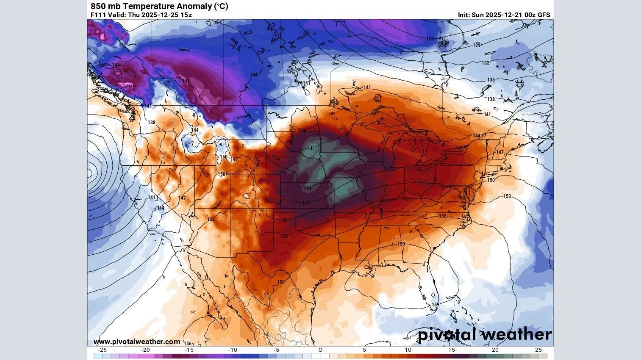
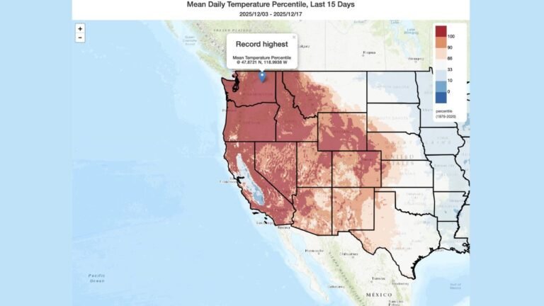
ST. LOUIS, MISSOURI — A historic late-December warm surge is expected to peak on Christmas Day, with forecast data indicating more than 100 record-breaking temperatures across the Midwest and central Plains, where the core of the abnormal warmth will be focused. Meteorologists say this setup could make Christmas 2025 one of the warmest ever recorded for many cities in the region.
Forecast models show a powerful upper-level ridge parked over the central United States, allowing unusually warm air to surge northward and overwhelm what would normally be deep winter cold.
Most Impacted Areas: Midwest and Central Plains
Based on the temperature anomaly data, the greatest concentration of record highs is expected across:
- Missouri — including St. Louis and surrounding metro areas
- Illinois — especially central and southern portions of the state
- Iowa — Des Moines and nearby communities
- Kansas — eastern and central Kansas, including Kansas City
- Oklahoma — Oklahoma City and much of central Oklahoma
In these areas, daytime highs are forecast to run 25 to 35 degrees above normal, with many locations reaching the upper 50s to mid-60s, levels more typical of early spring than late December.
Widespread Record Highs Likely
More than 40 daily record high temperatures are expected to be challenged or broken across the Midwest and Plains alone. Some records standing since the early to mid-1900s may fall as the warm air mass peaks on Christmas Day.
Meteorologists emphasize that this is not a narrow warm pocket, but a broad, multi-state event, which is why the number of potential records is unusually high.
Record-Warm Lows Extend the Impact West to East
In addition to daytime warmth, forecast guidance shows over 60 record-warm low temperatures possible from California through the Midwest, indicating that overnight cooling will be limited. While the West Coast, including parts of California, will see above-normal temperatures, the core heat anomaly remains centered over the central U.S.
Warm overnight lows are a key signal of how strong and persistent this air mass is, especially during what is typically the coldest week of December.
A Rare December Pattern
Climatologists note that while warm Christmas Days do happen, the scale and intensity of this event make it stand out. Many cities could experience one of their top-five warmest Christmas Days on record, underscoring how unusual this setup is for the season.
Despite the warmth, forecasters caution that winter patterns can shift quickly, and colder air could return after the holiday.
For continued updates on this historic Christmas warmth and how it may affect travel and holiday plans, stay with ChicagoMusicGuide.com.