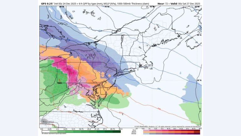
Pennsylvania, New York, New Jersey, Maryland, and New England Face Potential Snow and Ice Storm December 26–27 as Amplified Clipper System Develops
PENNSYLVANIA — A developing winter weather system is drawing close attention across the Northeast and Mid-Atlantic United States, as forecast data points to a more amplified clipper system capable of producing accumulating snow, sleet, and pockets of ice from Friday into early Saturday, December 26–27.
While a weaker clipper will move through the region ahead of this system, meteorologists emphasize that Friday’s setup carries a higher-impact potential, especially for inland and northern zones where colder air is more firmly in place.
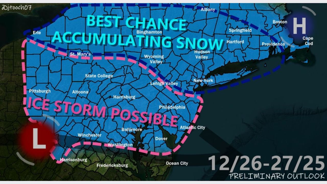
Best Chance for Accumulating Snow in Northern and Interior Zones
Forecast guidance highlights the highest probability for accumulating snow stretching across central and northern Pennsylvania, upstate New York, interior New England, and elevated terrain in the Northeast.
These areas sit on the colder side of the system, where temperatures are expected to remain near or below freezing for much of the event, allowing snow to accumulate more efficiently. Snowfall potential increases north and west of major metropolitan corridors, where colder air remains locked in longer.
Ice Storm Risk Increases Across the Mid-Atlantic Interior
Farther south and west, forecast models indicate a notable ice storm risk developing across portions of southern Pennsylvania, northern Maryland, and inland sections of the Mid-Atlantic.
In these areas, a warm layer aloft combined with sub-freezing surface temperatures could support freezing rain or sleet, particularly during the overnight and early morning hours. Even light ice accumulation could create hazardous travel conditions, especially on untreated roads and elevated surfaces.
Major Cities Face Mixed Impacts and Travel Disruptions
Urban corridors from Philadelphia northward through New York City and into southern New England appear likely to see mixed precipitation, with snowfall potentially changing to sleet or rain depending on timing and temperature trends.
Forecast projections suggest:
- Under 1 inch of snow near Philadelphia
- 1 to 3 inches closer to New York City and Boston
- Higher totals north and west of these cities
While totals may remain modest in city centers, slushy accumulation and brief icing could be enough to disrupt morning and evening travel, particularly along heavily traveled routes such as Interstate 95.
Temperature Contrast Drives Sharp Impact Differences
One of the defining features of this system is the tight temperature gradient across the region:
- Above-freezing conditions are expected across parts of central Maryland and coastal zones
- Near-freezing temperatures persist across southern Pennsylvania
- Below-freezing air dominates the Poconos, Lehigh Valley, interior New York, and New England
This contrast supports rapid changes in precipitation type, making localized impacts highly variable even over short distances.
Forecast Confidence Still Evolving
Meteorologists caution that this remains a preliminary outlook, with the exact storm track, thermal profiles, and precipitation amounts still subject to change. Small shifts in the system’s path could significantly alter where snow, ice, or rain dominate.
Residents across the affected states are urged to monitor updated forecasts, especially those planning holiday travel or early-morning commutes during the December 26–27 window.
What This Means for the Region
If current trends hold:
- Northern and interior areas face the greatest snow accumulation risk
- Mid-Atlantic interior zones face the highest ice potential
- Major cities may experience slushy snow and travel slowdowns rather than major accumulation
- Road conditions could deteriorate quickly during peak travel hours
Stay tuned to ChicagoMusicGuide.com for continued weather updates as this late-December winter system comes into clearer focus.