Maryland, Pennsylvania, New Jersey, and New York Face Friday Wintry Weather Threat as Freezing Rain, Sleet, and Snow Move Into the Region
MARYLAND — A strengthening winter system is increasingly likely to impact the Mid-Atlantic and Northeast late Friday into early Saturday, bringing a dangerous mix of freezing rain, sleet, and snow as cold air remains firmly in place across the region. Forecast data continues to show enough cold air near the surface to support wintry precipitation rather than plain rain, especially north and west of major cities.
Why This Storm Is Concerning
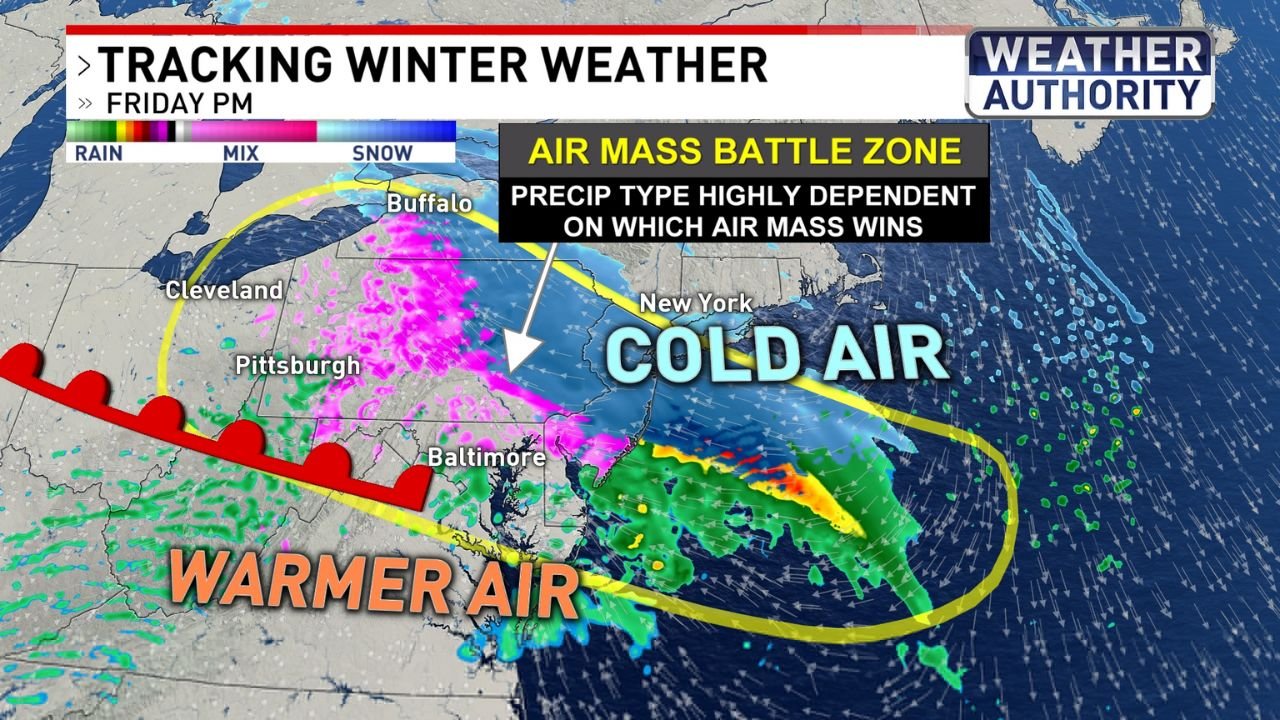
Meteorologists are highlighting this system because it involves a sharp air-mass battle between cold air locked in from the north and warmer, moisture-rich air pushing in from the south. The exact outcome will depend on which air mass wins in each location — a setup that often leads to rapid changes in precipitation type and hazardous travel conditions.
Cold air is expected to hold strongest across central and northern Pennsylvania, northern Maryland, New Jersey, and interior New York, increasing the risk of ice and sleet accumulations.
Freezing Rain and Sleet Likely in the Mid-Atlantic
Forecast guidance shows freezing rain and sleet becoming the dominant precipitation types across:
- Central and northern Maryland
- South-central and eastern Pennsylvania
- Northern West Virginia
- Interior portions of New Jersey
These areas sit directly within the transition zone, where surface temperatures hover near or below freezing while warmer air moves in aloft. Even light ice accumulation could lead to slick roads, hazardous bridges, and potential power disruptions.
Snow Favored Farther Northeast
Farther northeast, colder air is expected to remain more entrenched, allowing precipitation to fall primarily as snow. This includes:
- Eastern Pennsylvania
- Northern New Jersey
- Interior and upstate New York
Accumulating snow is most likely north and west of major metro areas, while cities closer to the coast may see more mixed precipitation depending on temperature trends.
Timing and Travel Impacts
The highest impact window is expected from Friday afternoon through early Saturday morning, a period that could coincide with increased travel. The presence of ice — especially freezing rain — raises concerns for:
- Rapidly deteriorating road conditions
- Slippery untreated surfaces
- Delays and disruptions to regional travel
Officials urge residents to closely monitor updates as small temperature changes could significantly alter impacts from one county to the next.
What to Watch Next
While confidence is growing that wintry weather will occur, exact precipitation types and amounts remain dependent on the evolving temperature profile. Shifts of just a few degrees could mean the difference between rain, sleet, or freezing rain.
Residents across the Mid-Atlantic and Northeast should prepare now for potential icy conditions, especially in areas historically prone to freezing rain.
Stay tuned to ChicagoMusicGuide.com for continued updates as this late-week winter threat becomes clearer.