Texas Braces for Early-Week Winter Pattern as Colder Air and Light Precipitation Move Into West Texas
TEXAS — A developing storm system is expected to move into West Texas late Sunday night and continue into Monday morning, bringing a noticeable shift toward colder temperatures and the potential for winter-related precipitation across parts of the state, according to forecast information from the National Weather Service office in Midland/Odessa.
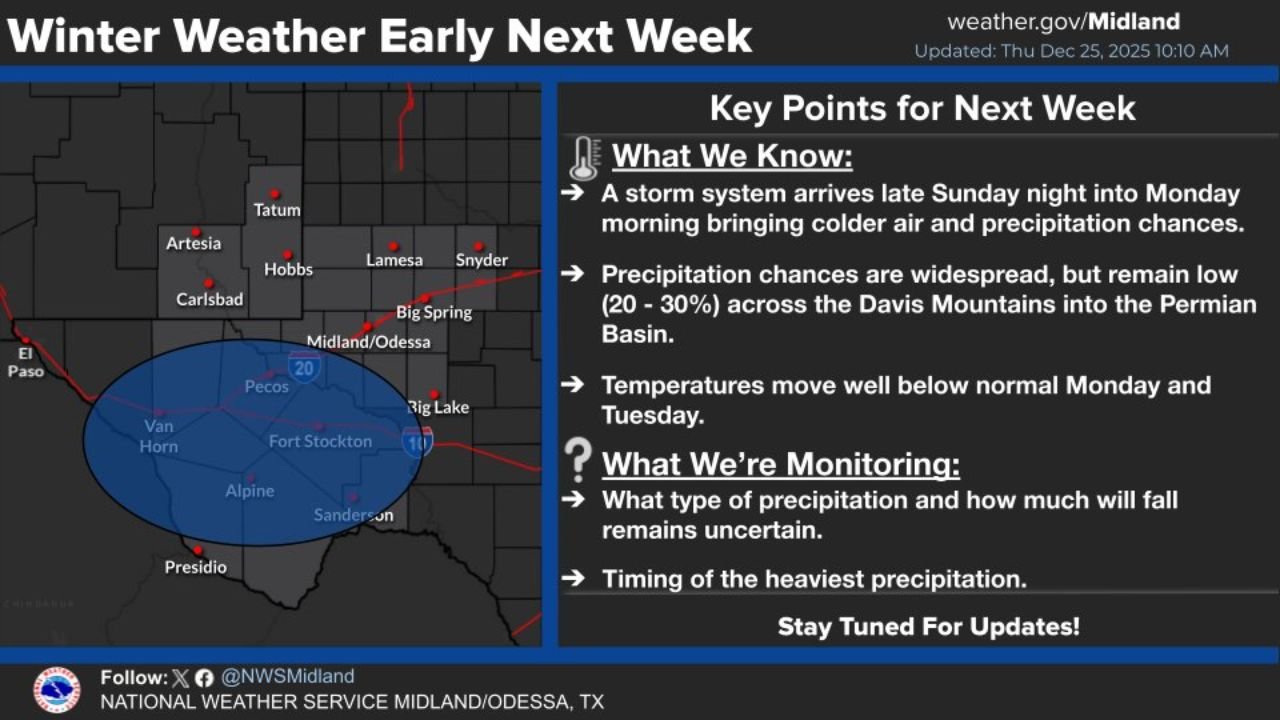
Storm System Arrives Late Sunday Into Monday
Forecast data indicates that a new weather system will enter the region late this weekend, pushing colder air southward into West Texas and the Permian Basin. While this system is not currently expected to be a major winter storm, it does signal a transition to below-normal temperatures and unsettled conditions to start the new week.
Meteorologists say the initial impacts are most likely to be felt overnight Sunday into Monday morning, with cloud cover increasing and temperatures beginning to fall as colder air moves in behind the system.
Low but Widespread Precipitation Chances
Precipitation chances are expected to be widespread but remain relatively low at this time, generally in the 20 to 30 percent range. These chances extend from the Davis Mountains eastward into the Permian Basin, including areas around Midland–Odessa, Fort Stockton, Alpine, and surrounding communities.
At this stage, forecasters caution that confidence remains limited regarding how much precipitation will fall and what form it may take. While rain appears most likely, the introduction of colder air raises questions about whether some locations could see a brief mix with winter precipitation, particularly during the coldest periods.
Colder Temperatures Below Seasonal Normals
One of the more certain aspects of the forecast is the temperature drop expected early next week. Highs and lows on Monday and Tuesday are projected to fall well below normal for late December, reinforcing the winter-like feel across much of West Texas.
Residents can expect noticeably colder mornings, especially in rural and higher-elevation areas, even if precipitation remains light or scattered.
What Forecasters Are Still Monitoring
Weather officials emphasize that several key details remain uncertain and will be refined over the coming days, including:
- The exact type of precipitation that develops as the system moves through
- How much precipitation ultimately falls across the region
- The timing of the heaviest precipitation, if any, during the system’s passage
Because of these uncertainties, residents are encouraged to monitor forecast updates closely as confidence improves.
What This Means for the Region
At this point, no major disruptions are expected, but the combination of colder air and precipitation potential could impact early-week travel and outdoor plans, especially during overnight and morning hours. Any changes in temperature trends could also influence whether winter precipitation becomes a greater concern.
Meteorologists advise checking updated forecasts over the next several days as the system approaches and additional data becomes available.
Stay Updated
Forecasters stress that this remains an evolving situation. With uncertainty still present, Texans across the affected areas should stay alert to forecast updates heading into the weekend and early next week.
For ongoing weather coverage, forecasts, and updates that may affect travel, events, and daily plans, keep following ChicagoMusicGuide.com.