Dangerous Ice Storm Threatens Maryland and Pennsylvania as Heavy Snow Falls Across New York Friday
MARYLAND — A significant and complex winter storm is set to impact much of the Northeast on Friday, bringing heavy snow to New York, while dangerous freezing rain and ice accumulation threaten large portions of Pennsylvania and Maryland, creating hazardous travel conditions and the potential for power outages.
Forecasters warn this will be a messy, high-impact winter system, with rapidly changing precipitation types and sharply different impacts depending on location. Ice Storm Warnings and Winter Storm Warnings are already in effect across multiple states as the storm intensifies through Friday afternoon and evening.
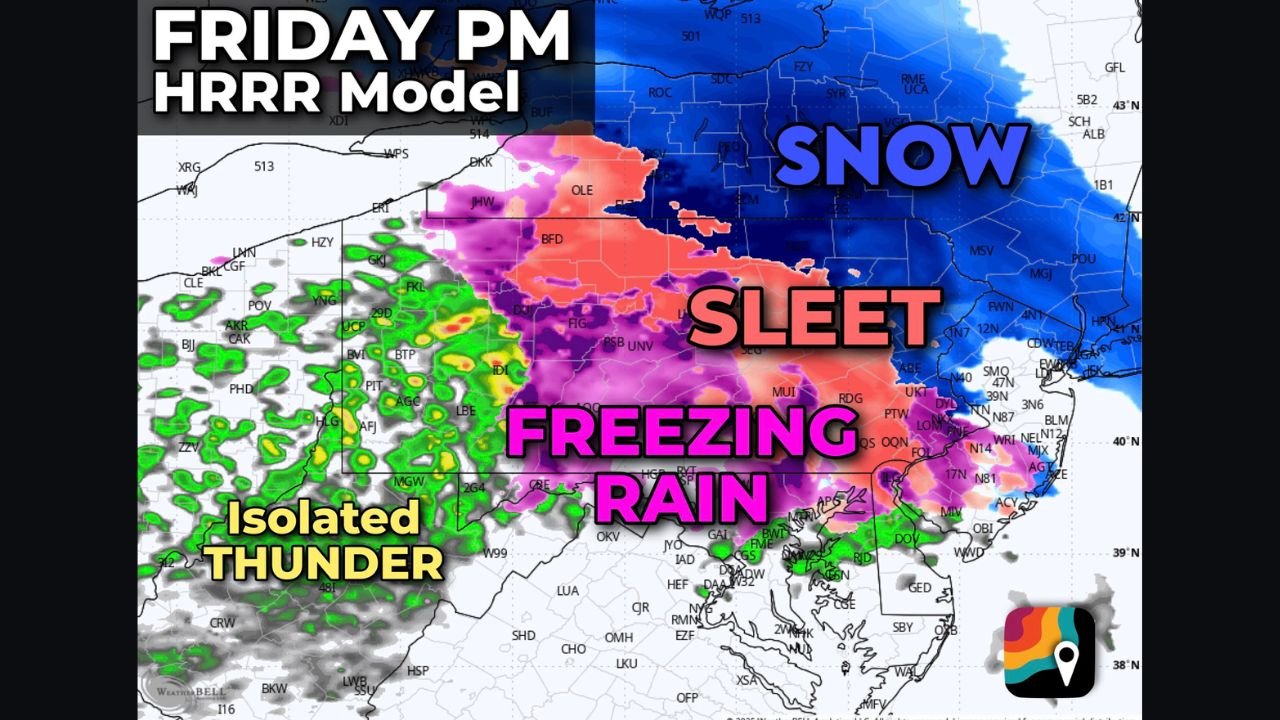
Heavy Snow Expected Across New York, Including New York City
New York State is expected to see the most widespread snowfall, with New York City and surrounding metro areas forecast to receive 6 to 8 inches of snow by Friday night. Snow is expected to begin during the afternoon hours, becoming moderate to heavy between roughly 4 p.m. and 11 p.m., when the strongest moisture and lift move through the region.
Areas north of the city — including parts of the Hudson Valley — could see higher totals of 8 to 10 inches, especially if snow bands develop and persist. Forecasters note that New York City sits close to the rain-snow line, meaning even slight shifts in temperature could alter totals, but confidence remains high for plowable snowfall across the metro area.
Ice Storm Warning for Central and Western Pennsylvania
While New York deals mainly with snow, central and western Pennsylvania face a more dangerous threat: ice.
Warm air aloft will override shallow cold air at the surface, allowing rain to fall and then freeze on contact, resulting in freezing rain and freezing drizzle. Some locations in central and western Pennsylvania could see 0.25 to 0.5 inches of ice accretion, enough to coat roads, trees, and power lines.
Meteorologists are particularly concerned because freezing drizzle — made up of smaller droplets — can freeze more efficiently than heavier rain, increasing the risk of widespread slick surfaces even before heavier precipitation arrives.
Travel may become extremely dangerous, and residents are urged to avoid roadways if possible during the height of the storm.
Ice Threat Extends Into Northern Maryland
The icy conditions may extend south of the Mason-Dixon Line into northern Maryland, where periods of freezing rain and sleet are also possible. While ice totals may be lower than in Pennsylvania, even light ice accumulation can cause hazardous travel, especially on untreated roads and bridges.
Power disruptions are possible in areas that receive prolonged freezing rain, particularly where ice builds on trees and power lines.
Mixed Precipitation and Isolated Thunder Possible
As the storm evolves, sleet and freezing rain will form a sharp transition zone between snow to the north and rain farther south. Some model guidance even suggests the potential for isolated thundersleet — a rare phenomenon where thunder occurs during sleet or freezing rain — particularly in parts of Pennsylvania.
This highlights the intensity of the system and the strong atmospheric dynamics driving it.
Timing and Peak Impacts
- Friday Afternoon: Snow develops in New York; freezing rain begins in Pennsylvania and Maryland
- Friday Evening: Heaviest snow in New York City and Hudson Valley; worst icing in central and western Pennsylvania
- Friday Night: Precipitation gradually tapers off from west to east, though slick conditions may persist overnight
Travel and Safety Concerns
Officials stress that this storm poses different dangers across short distances, making travel planning difficult. Snow-covered roads in New York and ice-coated highways in Pennsylvania and Maryland could both lead to accidents, delays, and cancellations.
Drivers are urged to:
- Delay non-essential travel
- Monitor local warnings and advisories
- Prepare for rapidly changing conditions
What Happens Next
Temperatures are expected to fall behind the storm, allowing refreezing of untreated surfaces overnight, prolonging hazardous conditions into early Saturday morning. Additional forecast updates are expected as meteorologists refine snowfall and ice totals.
Stay tuned to ChicagoMusicGuide.com for continued weather updates, regional impact reports, and safety information as this winter storm unfolds.