Colder Temperatures and Snow to Impact Washington and Northern Idaho With Slick Travel Expected Friday Into Saturday
SPOKANE, WASHINGTON — Colder air and a developing winter weather system are expected to impact Washington State and northern Idaho beginning Friday and continuing into early Saturday, with snowfall, falling snow levels, and slick travel conditions forecast across much of the Inland Northwest. The National Weather Service Spokane office warns that travel impacts could extend from mountain passes into lower-elevation valleys by Saturday morning as temperatures continue to drop.
Forecast briefings indicate that while snow will initially focus on higher terrain, rapidly cooling temperatures could allow slick conditions to spread into areas that primarily see rain early in the event.
What Weather Conditions Are Expected
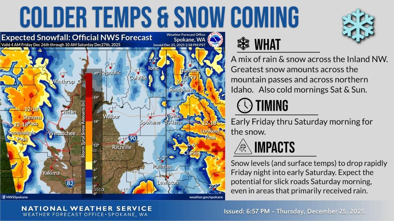
Forecasters are calling for a mix of rain and snow across the Inland Northwest, with the heaviest snowfall expected across mountain passes in Washington and across northern Idaho. Snow accumulation graphics show the highest totals concentrated near elevated terrain, while lower elevations may see lighter snowfall totals or rain changing to snow.
In addition to snowfall, cold morning temperatures are expected both Saturday and Sunday, increasing the risk of refreezing on roadways. Officials note that even areas receiving rain earlier could see slick surfaces once temperatures fall overnight.
Timing of the Snow and Cold Air
The snow event is expected to begin early Friday, intensify through Friday night, and taper off by Saturday morning. As colder air moves in late Friday night, snow levels are forecast to drop rapidly, increasing the likelihood of snow and icy conditions in valleys by daybreak Saturday.
Meteorologists emphasize that the Friday night to Saturday morning window will be the most impactful period for travel, particularly for holiday weekend traffic.
Expected Snowfall and Impacted Areas
Snowfall totals are forecast to be highest across Washington’s mountain passes, including areas along major travel routes where several inches of snow could accumulate. Parts of northern Idaho, especially higher elevations, are also expected to see notable snowfall.
While valley locations such as Spokane, Pullman, and nearby communities may see lower totals, forecasters caution that cold surface temperatures could still lead to icy patches, especially on bridges and untreated roads.
Travel Impacts and Safety Concerns
Transportation officials warn that holiday weekend travel could be affected across both states. Slick roads, reduced visibility during periods of snow, and rapidly changing conditions may make driving hazardous, particularly late Friday night and early Saturday.
Drivers are urged to use caution when traveling through mountain passes, monitor road conditions, and allow extra time. Even areas that primarily receive rain initially could experience icy conditions as temperatures drop overnight.
What Happens After the Storm
Snow is expected to diminish by Saturday morning, but cold temperatures will persist, keeping the risk of icy roads elevated into the weekend. No major warm-up is expected immediately following the system, meaning winter driving conditions could linger in shaded and higher-elevation areas.
Forecasters stress that conditions may change quickly, and travelers should stay informed as updates are issued.
As Washington and Idaho prepare for colder temperatures and accumulating snow, residents and travelers are encouraged to plan ahead and remain weather-aware throughout the holiday weekend. For continued coverage of winter weather, travel impacts, and regional forecasts, visit ChicagoMusicGuide.com for the latest updates.