New England Ice Storm Could Bring Up to 0.50 Inches of Ice to New York, Vermont, New Hampshire, and Maine on December 29
NEW ENGLAND AND NORTHEAST — A potentially significant ice storm is forecast to develop on Monday, December 29, impacting large portions of Upstate New York, Vermont, New Hampshire, western Maine, and nearby areas of Quebec and southeastern Ontario. Forecast models show a classic overrunning setup, raising concerns for dangerous to impossible travel, power outages, and widespread ice-related damage across higher elevations and interior regions.
Meteorologists warn that this system could become one of the more impactful ice events of the season if current projections hold.
Overrunning Setup Creates High Ice Accretion Risk
The developing storm is expected to feature a strong temperature inversion, with cold air entrenched at the surface across the Northeast while warmer air surges northward aloft ahead of a rapidly intensifying low-pressure system. This setup allows rain to fall through warm layers before freezing on contact with sub-freezing surfaces.
Surface temperatures are expected to remain in the upper 20s, while temperatures just a mile above the ground may rise into the 40s, creating ideal conditions for freezing rain rather than snow.
Ice Accumulations May Reach Power-Outage Thresholds
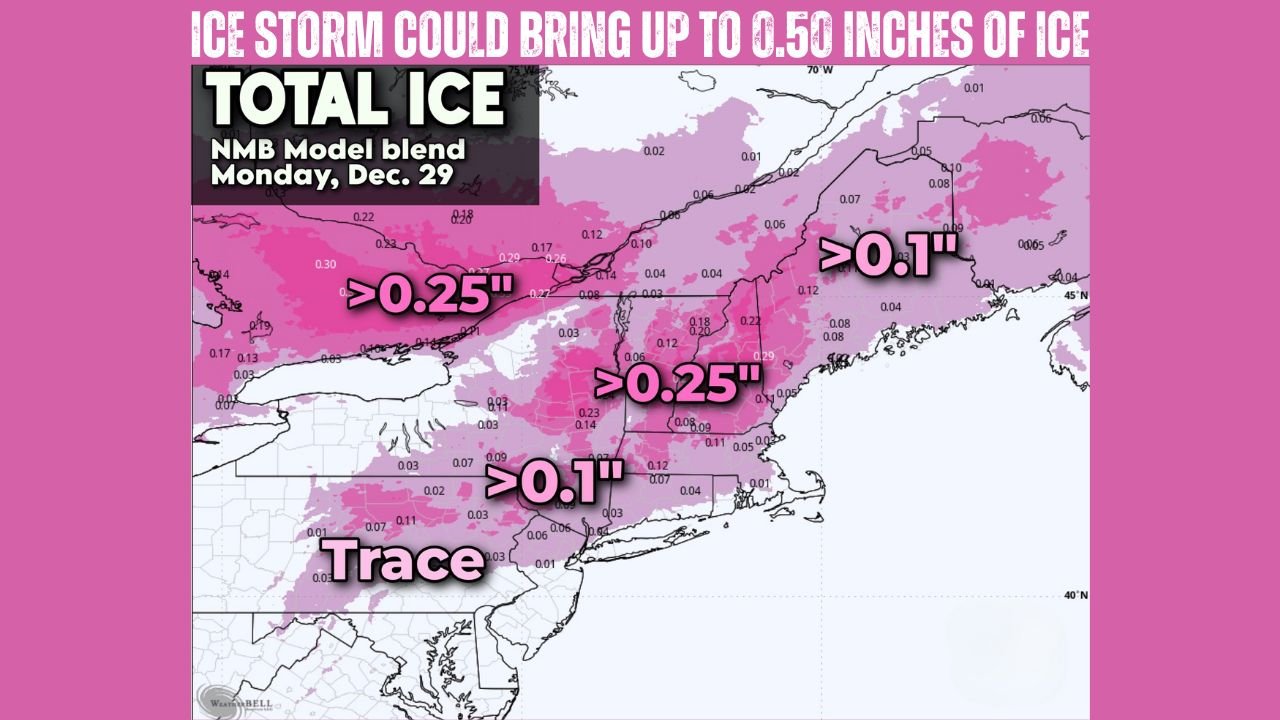
Forecast guidance, including blended model data, shows ice accretion approaching or exceeding 0.25 inches across a broad region, with localized totals nearing 0.50 inches in the most vulnerable areas. Ice amounts of this magnitude are widely considered a threshold for isolated to scattered power outages, as the weight of accumulated ice can snap tree limbs and pull down power lines.
The greatest ice potential appears focused across:
- Upstate New York, especially higher terrain
- Central and northern Vermont
- Interior New Hampshire
- Western and interior Maine
Lower elevations closer to the coast may see reduced ice amounts, but even small accumulations can create extremely hazardous road conditions.
Travel Conditions Likely to Become Dangerous or Impossible
With freezing rain expected to fall steadily during the event, roadways may quickly become glazed with ice, making travel hazardous even for treated roads. Elevated surfaces such as bridges, overpasses, and mountain roads are especially vulnerable.
Forecasters caution that conditions could deteriorate rapidly, particularly during peak travel hours on Monday. Residents are strongly advised to complete essential errands by Sunday evening, including grocery shopping and travel preparations.
Cross-Border Impacts Extend Into Canada
The ice threat is not limited to the United States. Portions of southern Quebec and southeastern Ontario are also expected to experience significant freezing rain, raising the potential for cross-border travel disruptions and power issues.
The international scope of this event underscores the strength and scale of the storm system as it intensifies.
Why This Could Become a High-Impact Event
Ice storms are among the most disruptive winter weather events due to their invisible but destructive nature. Unlike snow, freezing rain can cause damage with relatively small amounts, and recovery often takes longer due to infrastructure impacts.
The combination of cold surface air, strong warm advection aloft, and a rapidly deepening low-pressure system makes this setup particularly concerning for interior and mountainous regions.
As the Northeast braces for this potential ice storm, staying informed and prepared will be critical. For continued updates on New England winter weather, storm forecasts, and travel impacts, visit ChicagoMusicGuide.com for the latest coverage and analysis.