Kentucky Tornado Warning Issued for Henderson, Corydon, and Spottsville Until 7:30 PM CST as Radar Indicates Rotation
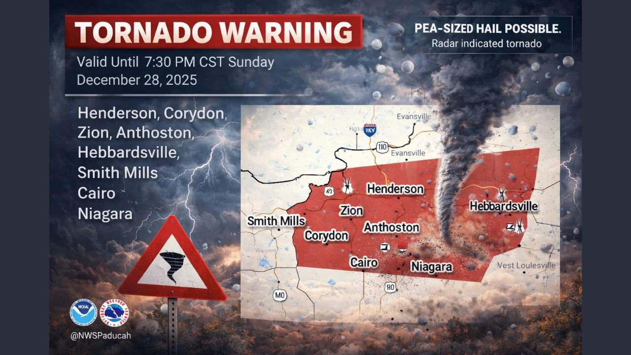
KENTUCKY — A Tornado Warning has been issued for parts of western Kentucky, including Henderson, Corydon, and Spottsville, as meteorologists warn of a dangerous storm capable of producing a tornado through 7:30 p.m. CST Sunday. The warning comes amid a broader high-impact storm system sweeping across the Midwest and Ohio Valley.
According to radar data, the storm showing rotation was detected moving across Henderson County, placing nearby communities under immediate threat. Officials urge residents in the warned area to take shelter immediately.
Which Areas Are Under the Tornado Warning
The warning zone includes several communities in western Kentucky, with the highest concern focused on:
- Henderson
- Corydon
- Spottsville
- Zion
- Anthoston
- Niagara
- Hebbardsville
- Cairo
- Smith Mills
The affected area covers a population of nearly 29,000 people, with multiple schools inside the warning polygon. No hospitals are located directly within the warned area, according to emergency mapping data.
What Meteorologists Are Seeing
The National Weather Service has classified this threat as radar-indicated, meaning atmospheric rotation strong enough to potentially produce a tornado has been observed on Doppler radar.
In addition to the tornado risk, forecasters note:
- Pea-sized hail is possible
- Strong thunderstorms are embedded within the system
- Rapid changes in storm intensity may occur
Even if a tornado does not fully touch down, damaging winds and sudden debris hazards remain a serious concern.
Why This Storm Is Especially Dangerous
This tornado warning is part of a larger, high-impact storm system affecting multiple states. North of the system, blizzard conditions are unfolding across parts of Minnesota and Michigan’s Upper Peninsula. South of the storm’s core, warmer air is fueling severe thunderstorms capable of producing tornadoes.
The sharp contrast in temperatures and strong wind shear are creating an environment favorable for fast-developing severe weather, particularly during the evening hours when visibility is lower.
What Residents Should Do Right Now
If you are in or near the warned area:
- Move to a basement or interior room on the lowest floor
- Stay away from windows and exterior walls
- Avoid mobile homes; seek sturdier shelter if possible
- Remain sheltered until the warning expires or officials give the all-clear
Drivers should avoid travel, as storms may intensify quickly and reduce visibility.
What Happens Next
The Tornado Warning remains in effect until 7:30 p.m. CST, but additional warnings could be issued if storms strengthen or shift eastward. Weather conditions across the region are evolving rapidly, and residents are urged to remain alert for further updates.
For music fans, venues, and travelers across the Midwest and Ohio Valley, this storm system could also impact evening plans and overnight travel, with weather disruptions likely to continue into Monday.
Stay weather-aware, stay safe, and keep checking ChicagoMusicGuide.com for the latest updates as this powerful storm system continues to unfold.