Michigan Braces for Crippling Lake-Effect Snow as Blizzard Conditions Threaten Travel Across Upper and Northern Lower Peninsula
MICHIGAN — A powerful lake-effect snow event is unfolding across Michigan, with forecasters warning that dangerous, potentially life-threatening travel conditions are expected through late Sunday night and into early Monday, particularly across the Upper Peninsula and northern portions of the Lower Peninsula.
According to updated snowfall projections issued Sunday evening, significant snow accumulation combined with strong winds will make travel extremely difficult — and in some areas, nearly impossible — before the storm finally begins to wind down late Monday night.
Snowfall Totals Increase as Storm Evolves
Meteorologists say snowfall forecasts have been refined but not weakened, with several key changes reflecting how the storm is evolving:
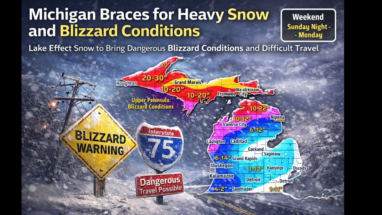
- The heaviest snow axis has shifted slightly south, pulling higher totals deeper into northern Lower Michigan.
- A previously forecast 20–30 inch zone over the Keweenaw Peninsula was removed, but totals remain substantial elsewhere.
- Portions of far northern Lower Michigan are now projected to receive 10–20 inches of snow.
- Snowfall bands across eastern Upper Michigan and northern Lower Michigan were increased, with 6–12 inches now expected in several regions.
Confidence remains lower on exact placement of the heaviest bands, but forecasters stress that lake-effect snow will persist for hours, allowing totals to rapidly climb wherever bands stall.
Blizzard Conditions Expected in the Upper Peninsula
The most severe impacts are expected across Michigan’s Upper Peninsula, where blizzard conditions are likely to develop and persist.
Key concerns include:
- Sustained winds of 45–60 mph
- Near-zero visibility during intense snow squalls
- Rapid snow accumulation making road clearing difficult or impossible
- Whiteout conditions along exposed roadways
Officials warn that travel across much of the Upper Peninsula should be avoided, especially overnight and into Monday morning.
Northern Lower Michigan Faces Hazardous Travel
While not as extreme as conditions farther north, western and northern Lower Michigan will still experience dangerous weather.
Forecast highlights include:
- 6–12 inches of snow across areas such as Gaylord, Cadillac, and Traverse City
- 4–8 inches along parts of the Lake Michigan shoreline
- Blowing and drifting snow, reducing visibility even after snowfall eases
- Wind gusts strong enough to cause difficult driving for high-profile vehicles
Even areas receiving lower totals may see brief whiteouts as snow squalls move inland from Lake Michigan.
Timing: When Conditions Will Be Worst
- Sunday evening through early Monday morning will be the most dangerous period
- Lake-effect snow bands will continue shifting and redeveloping through Monday
- Travel conditions may not improve significantly until late Monday night
Forecasters note that snow is “just getting started” in several areas, meaning conditions may worsen rapidly with little warning.
Travel Strongly Discouraged
Transportation officials urge residents to delay or cancel non-essential travel, especially in warning areas. Emergency crews may struggle to reach stranded motorists during the peak of the storm.
Drivers who must travel are advised to:
- Carry a winter emergency kit
- Keep fuel tanks full
- Monitor road closures and local alerts closely
Air travelers are also encouraged to check flight status, as delays and cancellations are likely across the region.
What Comes Next
Meteorologists say additional briefings and arrival-time updates will be issued as lake-effect bands evolve. While snowfall will eventually taper off, lingering blowing snow and icy roads could continue to impact travel into Tuesday.
For continued updates on severe weather impacting Michigan and the Midwest — and how it may affect concerts, travel plans, and live events — stay connected with ChicagoMusicGuide.com, your source for weather updates that matter to music fans on the move.