Southern California Stormy New Year Brings Heavy Rain, Flooding Risks, and Mudslide Concerns Across Coastal Counties
SOUTHERN CALIFORNIA — A multi-day storm system is set to impact Southern California through New Year’s Eve and New Year’s Day, bringing periods of moderate to heavy rainfall, gusty winds, and elevated risks of flooding, mudslides, and downed trees, according to forecast data from the National Weather Service.
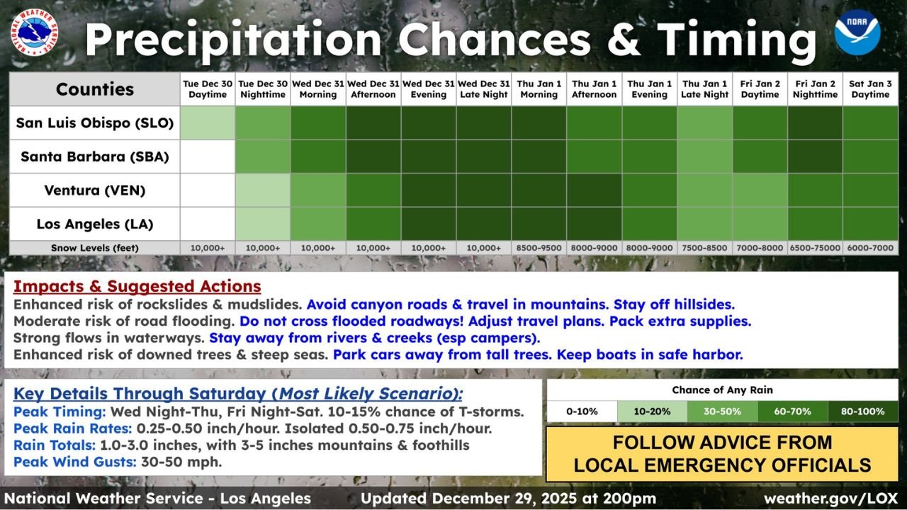
The areas facing the greatest impacts include San Luis Obispo County, Santa Barbara County, Ventura County, and Los Angeles County, where rain chances increase steadily through midweek and remain elevated into Saturday.
Rain Timing Shows Multiple Waves Through New Year’s Weekend
Forecast timing graphics show rain developing Tuesday night, becoming more widespread Wednesday into Thursday, and continuing in on-and-off waves through Friday and Saturday.
The highest coverage of rainfall is expected:
- Wednesday night into Thursday
- Friday night into early Saturday
Rain chances increase from 30–50% early to 60–100% during peak periods, especially along the coastal and foothill zones.
Flooding and Mudslide Risks Increase in Burn Scars and Hillsides
With persistent rainfall over multiple days, the data highlights enhanced risk of rockslides and mudslides, particularly:
- Along canyon roads
- Near steep hillsides
- In recent burn scar areas
Emergency guidance advises residents to:
- Avoid canyon roads and mountain travel
- Stay off steep slopes during heavy rain
- Monitor rapidly changing conditions overnight
Localized Road Flooding and Strong Waterway Flows Expected
Rainfall rates are projected to reach 0.25–0.50 inches per hour, with isolated bursts up to 0.75 inches per hour, increasing the likelihood of:
- Urban street flooding
- Ponding on highways
- Fast-moving creeks and rivers
Motorists are urged to never cross flooded roadways and adjust travel plans during peak rain windows.
Wind Gusts and Downed Tree Threats Add to Impacts
Forecast guidance also shows wind gusts reaching 30–50 mph, which could lead to:
- Downed trees
- Power outages
- Hazardous marine conditions
Coastal and boating interests are advised to keep vessels secured in safe harbor, while residents should park vehicles away from tall trees.
Snow Levels Remain High but Slowly Lower Late Week
Snow levels are expected to remain near or above 10,000 feet early, lowering gradually toward:
- 8,000–9,000 feet Thursday
- 6,000–7,000 feet by Saturday
This limits widespread snowfall impacts but could affect higher mountain passes later in the week.
What This Means for New Year’s Plans
Residents across San Luis Obispo, Santa Barbara, Ventura, and Los Angeles counties should prepare for:
- A wet New Year’s Eve and Day
- Travel delays
- Potential emergency alerts if rainfall intensifies
Officials strongly advise staying informed and following local emergency guidance as conditions evolve.
Stay weather-aware and plan ahead.
How is this storm expected to impact your New Year’s plans or travel? Share your thoughts and stay connected with the latest updates at ChicagoMusicGuide.com.