Syracuse, New York Buried by Historic Lake-Effect Snow as Airport Tops 16 Inches Overnight and Season Total Nears 70 Inches
SYRACUSE, NEW YORK — Central New York is in the grip of an intense and persistent lake-effect snow event, with Syracuse emerging as the hardest-hit location. Data from the National Weather Service and regional snowfall reports show Syracuse Hancock International Airport recorded around 16 inches of snow overnight, with up to another 8 inches possible today under an ongoing Winter Storm Warning. If current projections verify, Syracuse’s seasonal snowfall could exceed 70 inches, placing the city nearly three feet above its long-term average for this point in the winter.
Lake-Effect Bands Locked Over Central New York
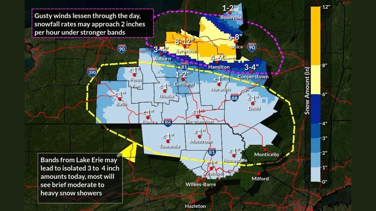
Meteorological analysis indicates a strong northwest flow off Lake Ontario has kept narrow but powerful snow bands trained over the same areas for hours at a time. These bands are capable of producing snowfall rates approaching 2 inches per hour, especially when mesoscale features intensify. The result has been dramatic contrasts across short distances: neighborhoods under the core band have seen double-digit totals, while areas just south experience lighter accumulations.
Where the Heaviest Snow Is Falling
Forecast graphics from National Weather Service Binghamton highlight a corridor of maximum impact from Syracuse through parts of Oswego and Madison counties, with 8–12 inches common in the most persistent bands. Surrounding communities such as Auburn, Utica, and Hamilton are generally seeing 3–6 inches, while locations farther south—including Ithaca, Binghamton, and the Southern Tier—remain largely outside the main band with under 1–2 inches.
Travel Disruptions and Safety Concerns
With the heaviest snow occurring from evening through the overnight hours, road conditions have deteriorated rapidly. Visibility drops sharply during squalls, and brief whiteout conditions are possible when bands intensify. Transportation officials urge drivers to avoid unnecessary travel, particularly on Interstate 81 and Interstate 90, where lake-effect bursts can quickly overwhelm plowed surfaces.
What Happens Next
The current pattern suggests lake-effect snow will continue at least into Thursday, though the exact placement of bands may wobble north or south. Even small shifts could mean another round of heavy accumulation for Syracuse or nearby communities. Winds are expected to gradually ease, but periodic bursts of moderate to heavy snow remain likely.
A Remarkable Start to Winter in Syracuse
Climatologically, Syracuse is no stranger to snow, but approaching 70 inches before mid-winter is exceptional. If additional accumulations materialize today, this event could rank among the most impactful early-season lake-effect episodes in recent years, with implications for travel, infrastructure, and daily life across Central New York.
Have you been dealing with this storm or adjusting plans because of the snow? Share your experience and how winter weather is affecting events and travel—join the conversation with readers at ChicagoMusicGuide.com.