
A Multi-Day Severe Weather Pattern Is Targeting the Central United States Through the Weekend as Model Data Shows Back-to-Back High-Probability Storm Corridors From Oklahoma and Kansas to Kentucky and the Southeast
KANSAS CITY, MO — The central United States is entering one of the most active severe weather stretches of the young spring season, with back-to-back high-probability storm corridors locked into the eight-day outlook and model data showing the kind of agreement that forecasters pay close attention to — two independent atmospheric models both flagging the same days, the same regions, and the same dangerous peak.
The pattern is not a one-day event. It is a sequence, and it begins now.
The Eight-Day Severe Weather Sequence in Full
Current analysis of the extended severe weather probability outlook, initialized Tuesday morning, reveals a clear and repeating pattern: the central and southern Plains are the primary target through midweek, the threat briefly shifts toward the Northeast by late week, then a second significant severe weather corridor reloads across the central United States heading into the weekend, before the system finally pushes into the Southeast by early next week.
Two independent high-resolution ensemble model runs — initialized from the same starting data on Tuesday, March 31 — are in strong agreement on the structure of this pattern, though they differ on the intensity. That agreement across different modeling systems adds confidence to the overall threat timeline.
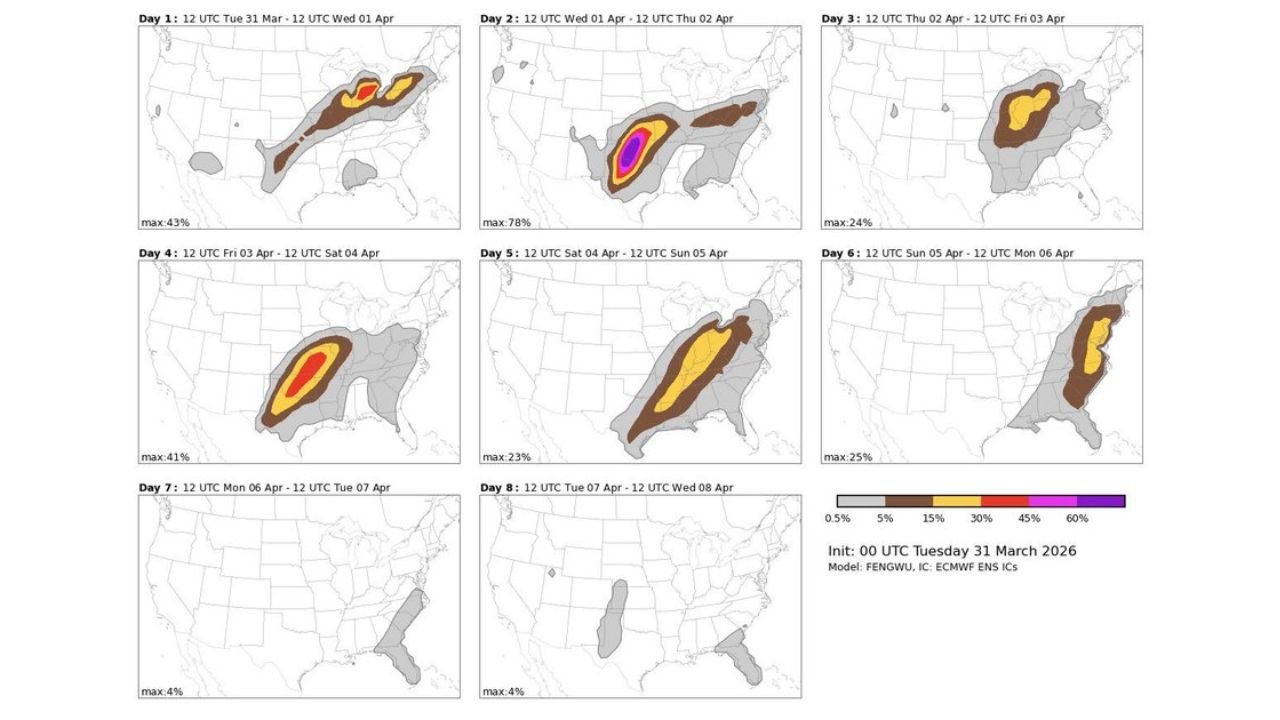
Day 2: Wednesday Into Thursday — The Highest-Probability Event of the Entire Outlook
The clearest and most dangerous signal in the entire eight-day window falls on Wednesday into Thursday, April 2. Both model runs spike to their highest probability values of the entire outlook period during this 24-hour window, with the bullseye centered over Oklahoma, Kansas, and Missouri.
One model run places the peak severe weather probability at 53% for this corridor. The second, independent model run pushes that peak even higher — to 78%. A probability value of 78% for organized severe weather in a specific region represents an extraordinarily high level of model confidence for a multi-day outlook. The core of highest risk on both models is depicted in the deepest color tier on the probability scale, concentrated over the Oklahoma City to Wichita to Kansas City corridor.
The main threats for this event — damaging winds exceeding 75 mph, hail larger than 2 inches in diameter, and tornadoes — remain consistent with what current analysis has already established for Wednesday. The storm mode is expected to be primarily linear, which focuses the wind and hail threats, but a tornado corridor from North Texas to Western Missouri remains in play.
Day 1: Tuesday Into Wednesday — The Opening Act
Before the peak Wednesday event, the outlook shows an active Day 1 corridor across the central Plains and Midwest. One model places maximum probabilities at 43% for Tuesday into Wednesday, with the second model showing 36% for the same period. Both depict storm activity stretching from the southern Plains northeastward through the Great Lakes region, consistent with the active spring pattern already in place.
Day 3: Thursday Into Friday — The Threat Pivots Northeast
Following the peak Wednesday event, the severe weather energy shifts rapidly toward the Northeast and Mid-Atlantic by Thursday into Friday, April 3. Both models show a concentrated probability zone — with values reaching 24 to 36% — focused on a corridor stretching from the mid-Atlantic coast northward into New England. Residents in Pennsylvania, New York, New Jersey, and New England should monitor Thursday’s evolution closely as the system tracks east.
Day 4: Friday Into Saturday — The Second Major Signal
Perhaps the most important finding beyond the Wednesday peak is what the data shows for Friday into Saturday, April 4. Both model runs bring a significant secondary severe weather corridor back to the central United States, with the storm track positioned similarly to the Wednesday event but potentially shifted slightly in track.
One model places Day 4 maximum probabilities at 41% with a red-core bullseye over the central Plains — the second highest reading in its entire eight-day run. The second model shows 24% for the same period. A 41% maximum probability on Day 4 of an extended outlook represents a meaningful and serious signal that a second round of significant severe weather is possible heading into the weekend.
For Kentucky specifically, current analysis indicates Saturday represents the second-best local chance for severe weather after Wednesday, with the outcome highly dependent on how Friday’s central Plains event evolves before pushing eastward.
Eight-Day Model Probability Comparison
| Day | Period | Primary Region | Model 1 Max | Model 2 Max |
|---|---|---|---|---|
| Day 1 | Tue Mar 31 – Wed Apr 1 | Central Plains/Midwest | 36% | 43% |
| Day 2 | Wed Apr 1 – Thu Apr 2 | Oklahoma/Kansas/Missouri | 53% | 78% |
| Day 3 | Thu Apr 2 – Fri Apr 3 | Northeast/Mid-Atlantic | 36% | 24% |
| Day 4 | Fri Apr 3 – Sat Apr 4 | Central US/Plains | 24% | 41% |
| Day 5 | Sat Apr 4 – Sun Apr 5 | Central/Southeast | 17% | 23% |
| Day 6 | Sun Apr 5 – Mon Apr 6 | Southeast/East Coast | 17% | 25% |
| Day 7 | Mon Apr 6 – Tue Apr 7 | Minimal | 2% | 4% |
| Day 8 | Tue Apr 7 – Wed Apr 8 | Minimal | 3% | 4% |
State-by-State Focus Through the Pattern
🔴 Oklahoma, Kansas, Missouri — The core target for the highest-probability event of the entire eight-day window on Wednesday. Both model runs place the peak probability bullseye directly over this corridor. All severe hazards are in play. Wednesday is the priority day for these states.
🔴 Texas (North and Central) — Inside both the Day 1 and Day 2 elevated probability zones. The tornado corridor from North Texas to Western Missouri runs directly through this region. Active severe weather threat Tuesday through Wednesday evening.
🟠 Kentucky, Tennessee, Arkansas — Elevated risk zone across multiple days. Wednesday brings the best local severe weather chance with pop-up thunderstorm potential and downburst winds. Saturday represents a secondary threat dependent on Friday’s western storm evolution. The probability signal for Day 5 shows this corridor in the 17 to 23% range.
🟠 Pennsylvania, New York, New Jersey, New England — The Day 3 Thursday into Friday signal focuses on this region, with probabilities reaching 24 to 36%. Residents in the Northeast should watch Thursday’s evolution for potential organized severe weather.
🟡 Mississippi, Alabama, Georgia, Florida — The Day 5 and Day 6 signals push through the Southeast corridor from Saturday into early next week. Probabilities of 17 to 25% keep the Southeast in play for organized severe weather through the weekend.
🟡 Illinois, Indiana, Ohio — Inside the broader probability envelope for multiple days but outside the highest-risk cores. Severe thunderstorm potential exists particularly around the Wednesday and Saturday windows.
🟢 Pacific Coast, Mountain West, Northern Plains — Outside the primary severe weather corridors across the entire eight-day outlook period.
Forecast Confidence
Forecast Confidence: High for Wednesday, Moderate for Day 4 Friday/Saturday, Low-to-Moderate Beyond Day 5.
The Wednesday peak event carries the highest confidence of the entire outlook. Both independent model systems agree on location, timing, and intensity magnitude, with maximum probabilities of 53% and 78% representing exceptional model agreement for a 48-hour forecast. The Friday into Saturday secondary event is a real and credible signal — a 41% maximum probability on Day 4 is not noise — but carries more uncertainty in exact track and timing as the pattern evolves.
Beyond Day 5, probability values drop significantly and uncertainty grows. The Southeast corridor through the weekend is worth monitoring but should not be treated with the same urgency as the Wednesday bullseye. Residents across the central Plains, southern Plains, Ohio Valley, Kentucky, and the Northeast should build awareness of the multi-day nature of this pattern and maintain weather alertness through at least next weekend.
More multi-day severe weather pattern coverage is always on the horizon. Stay informed at ChicagoMusicGuide.com — your source for extended severe storm outlooks across the Plains, the Ohio Valley, and the entire United States.