
Alabama Christmas Week Weather Swings From 70s to Freezing as Huntsville Forecast Shows Sharp Temperature Drop
UNITED STATES — A dramatic weather roller coaster is setting up across Alabama, with new forecast data showing unseasonably warm temperatures through Christmas Day followed by a sharp plunge into winter-like cold early next week, according to the latest temperature projections centered on Huntsville.
Forecast guidance indicates highs climbing into the upper 60s and low to mid-70s from Christmas Eve through Saturday, creating a springlike feel across North Alabama. However, a strong cold front arriving Sunday is expected to bring rain, gusty conditions, and a rapid temperature drop, with highs falling into the 30s by Monday and overnight lows dipping into the 20s.
Warm Christmas Stretch Brings Near-Record December Temperatures
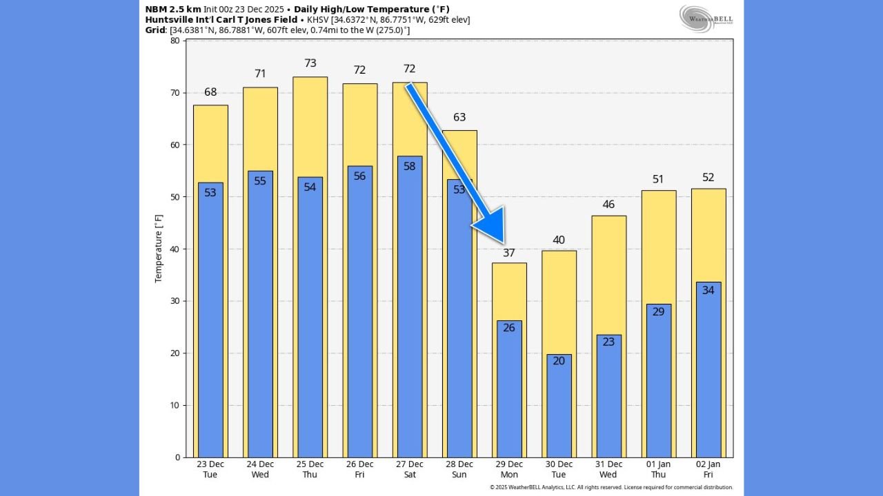
The meteorogram for Huntsville International Airport shows a prolonged warm pattern dominating the holiday period. Daily highs are projected to reach 71°F Wednesday, 73°F Christmas Day, and 72°F Friday and Saturday, well above typical late-December averages for North Alabama.
Overnight lows during this stretch are also expected to remain mild, generally holding in the mid-to-upper 50s, reinforcing the unseasonable warmth. This setup is being driven by persistent southerly flow ahead of an approaching cold front, allowing warm Gulf air to surge northward into the Tennessee Valley.
For holiday travelers and outdoor plans, conditions through Saturday look favorable, with dry weather and springlike temperatures dominating much of the region.
Cold Front Sunday Triggers Rapid Shift to Winter Conditions
The pattern changes abruptly on Sunday, when a cold front is forecast to sweep through Alabama, bringing showers and a noticeable drop in temperatures. Highs are expected to fall from the low 70s Saturday to around 63°F Sunday, then tumble further as colder air pours in behind the front.
By Monday, forecast highs in Huntsville drop to around 37°F, with overnight lows falling into the mid-20s. Tuesday remains cold, with highs near 40°F, before a gradual rebound later in the week. The sharp temperature decline — nearly 35 degrees in just two days — underscores the intensity of the cold air mass behind the front.
While no winter precipitation is currently indicated for North Alabama, the cold snap will feel especially stark following several days of near-record warmth.
What Alabama Residents Should Prepare For
The sudden transition from springlike warmth to freezing temperatures may catch some residents off guard. Those with outdoor plumbing, pets, or travel plans early next week should prepare for hard freezes and colder-than-recent conditions.
Energy demand is also expected to rise sharply as heating systems are brought back online after several mild days. Drivers should remain alert for wet roads Sunday, followed by cold mornings early next week that could lead to isolated slick spots if moisture lingers.
As Alabama experiences yet another reminder of how volatile winter weather can be in the South, staying weather-aware will be key. For continued updates on holiday travel weather, regional forecasts, and major weather shifts impacting communities nationwide, visit ChicagoMusicGuide.com for the latest coverage.