Alabama, Georgia, and the Carolinas Face Cold Air but Little Snow as Models Downgrade Southern Winter Weekend

United States — Questions have surged this week about whether snow is possible across the Deep South, especially heading into the upcoming weekend. While cold air will be firmly in place, updated forecast data shows that snow accumulation remains unlikely for Alabama and much of the southern tier, despite widespread speculation circulating on social media.
New guidance from the European ensemble model (ECMWF) and the American GFS highlights a familiar winter scenario for the South: cold enough air, but limited moisture and poor alignment for meaningful snowfall.
Cold Air Is Real — Snow Is the Uncertain Part
There is high confidence that Arctic air will push southward, bringing some of the coldest temperatures of the season into Alabama, Georgia, Mississippi, and the Carolinas. Morning lows will dip sharply, and wind chills may briefly fall into the 20s and lower 30s across areas that rarely see winter extremes.
However, cold alone does not guarantee snow, especially in the southern U.S. Forecast confidence drops significantly when examining how much moisture overlaps the cold air mass.
European Model vs. GFS: Why the Forecast Is Confusing
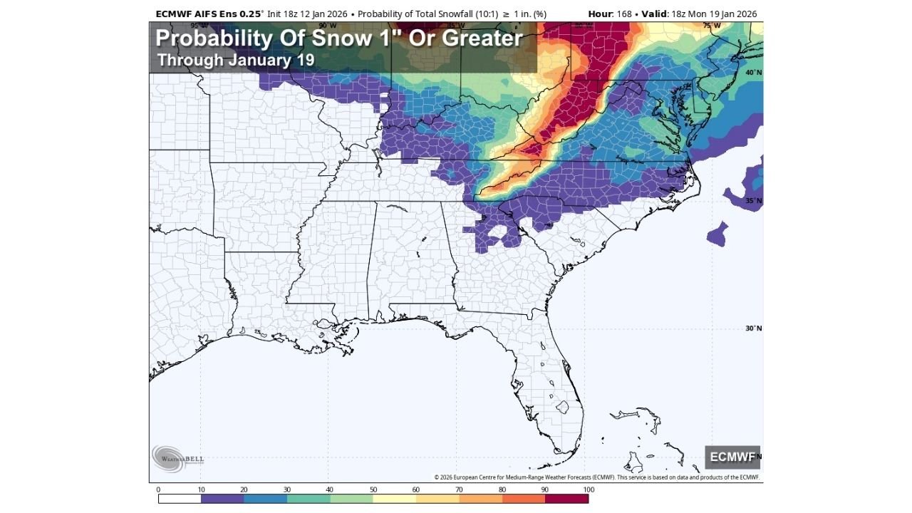
The European model remains the only major system occasionally showing widespread snow potential, particularly farther north into Tennessee, the central Appalachians, and parts of the Mid-Atlantic. In contrast, the GFS model continues to limit snow to scattered, light areas, with most precipitation falling as rain or mixed precipitation near the Gulf Coast.
Meteorologists caution that the GFS has known winter biases, but even the more reliable European ensemble has steadily reduced snowfall probabilities in recent runs.
Snow Probabilities Drop to Zero in Alabama
According to the ECMWF ensemble probability map, the chance of one inch of snow or more through Monday, January 19 is effectively zero across Alabama. While brief flurries cannot be ruled out Wednesday night or again over the weekend, no accumulation or travel impact is expected.
This aligns with long-range ensemble trends showing weak lift, shallow cold layers, and poor moisture timing, all of which severely limit snowfall potential.
Where Snow Is Still Most Likely
The highest snow probabilities remain north and east of the Deep South, extending from the Ohio Valley into parts of the Mid-Atlantic and Northeast, where stronger dynamics and better moisture overlap persist.
For the southern tier states, including Mississippi, Alabama, and southern Georgia, the signal continues to favor cold, dry air rather than a true winter storm.
Why Social Media Snow Maps Are Misleading
Many viral snow maps circulating online are based on single deterministic runs, not ensemble probabilities. Forecasting winter weather in the South requires precise alignment of temperature depth, moisture, and timing — a balance that is notoriously difficult to achieve more than a few days out.
Experienced forecasters emphasize that most southern winter events fail quietly, producing cold air without snow, even when models briefly suggest otherwise.
Bottom Line
- Cold air: Very likely
- Flurries: Possible
- Accumulating snow in Alabama: Extremely unlikely
- Major impacts: Not expected
Forecasts may continue to evolve, but at this point, there is no reason for panic — and no evidence supporting a southern snowstorm scenario.
For continued weather updates, regional impact analysis, and how shifting conditions could affect travel and live events, stay connected with ChicagoMusicGuide.com as we track the rest of this winter pattern.
