
Alabama, North Carolina, South Carolina and Virginia Track Arctic Front as Atlantic Storm Raises Weekend Snow Risk
UNITED STATES — A fresh surge of Arctic air is set to move south across the eastern United States this weekend, setting the stage for sharply colder temperatures in Alabama while a strengthening Atlantic storm system raises the potential for snow impacts across the Carolinas and parts of Virginia late Saturday into Sunday.
Forecast guidance shows a consistent large-scale pattern: cold air driven south by the jet stream, paired with atmospheric blocking over the North Atlantic. This combination favors storm development offshore and creates uncertainty around how close that storm ultimately tracks to the East Coast — a factor that will determine who sees snow and who avoids significant impacts.
Alabama: Arctic Front Brings Bitter Cold, Minor Snow Chances
Another Arctic front is expected to pass through Alabama late Friday into Saturday, reinforcing cold air already in place. As the front moves through, a few sprinkles or flurries may occur, but no widespread or impactful snowfall is expected across the state.
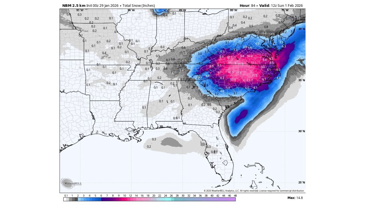
As a surface low organizes offshore along the Atlantic coast, snow showers become possible across northern Alabama Friday night into Saturday. While most areas will see little to no accumulation, isolated heavier snow showers could drop up to a quarter inch in a few spots by midday Saturday, with the highest probability across northeast Alabama.
Temperatures will be the bigger story. North and Central Alabama are expected to remain in the 20s on Saturday, after starting the morning in the teens. In colder pockets of north Alabama, lows early Sunday morning could fall into the single digits, similar to the cold experienced earlier this week.
Any travel impacts in Alabama would be very limited and localized, confined to brief heavier snow showers rather than widespread accumulation.
Carolinas and Virginia: Primary Zone for Weekend Snow Risk
While Alabama remains on the fringe, the Carolinas and parts of Virginia sit closer to the core of potential impacts. Model guidance indicates that snow is most likely to develop late Saturday into Sunday, particularly near the coast and inland areas just west of the shoreline.
This is not a locked-in blizzard scenario, but it is a setup that meteorologists closely monitor due to its history of northwest shifts as the event approaches. Even small changes in storm track could significantly increase snowfall totals for parts of North Carolina, South Carolina, and Virginia.
The current trend leans toward a narrow miss, with the storm tracking slightly offshore and limiting impacts. However, forecasters note that these systems often trend closer to the coast in later model runs, which would expand snowfall inland.
Why This Setup Matters
The key ingredient is very cold air already in place. Any snow that does fall would be dry and fluffy, with high snow-to-liquid ratios, meaning even small amounts of moisture could translate into noticeable snowfall in affected areas.
Because of this, areas that normally see little snow could end up with more than expected, even if precipitation totals remain modest.
Bottom Line
- Alabama: Bitter cold dominates; only spotty, light snow showers possible in the north
- North Carolina, South Carolina, Virginia: Highest risk for snow late Saturday into Sunday
- East Coast: Storm track remains uncertain, and small shifts could change impacts quickly
Forecasters will continue watching how close the Atlantic storm tracks to the coast. While a major winter storm is not guaranteed, the pattern supports enough uncertainty that residents across the East Coast should stay alert through the weekend.
Stay with ChicagoMusicGuide.com as we continue tracking this evolving winter weather pattern through the weekend. We’ll provide timely updates on temperature drops, snow potential, and any shifts in the storm track that could impact travel or daily plans across the affected states.