
Alabama, Tennessee, Mississippi, and Georgia Face Increased Late-January Snow Potential as Colder Pattern Returns, Though Forecast Confidence Remains Limited
UNITED STATES — A significant pattern shift toward colder air is unfolding across the Deep South and Tennessee Valley, raising measured—but not extreme—concerns for winter weather potential later this month. While social media speculation has surged with claims of blizzards and major snowstorms, the latest ensemble guidance and temperature forecasts suggest a more cautious and realistic outlook.
Meteorological data from long-range ensemble models indicates increasing probabilities for light snowfall, particularly across northern Alabama, the Tennessee Valley, and parts of Mississippi and Tennessee, as colder air filters southward through mid-to-late January.
Snow Probabilities Increase but Remain Moderate
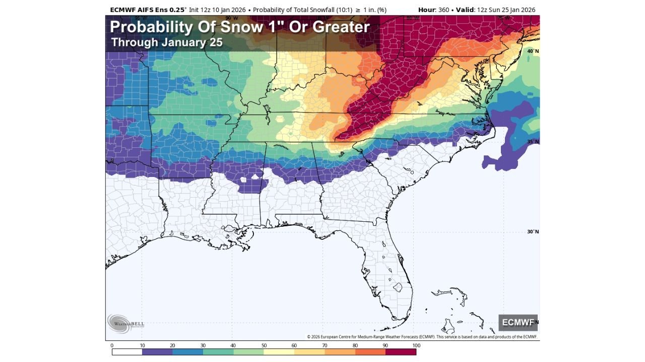
The latest European ensemble snowfall probability map shows a 40–50 percent chance of at least one inch of snow through January 25 across the Tennessee Valley region. These probabilities have increased compared to earlier runs but remain within a range that supports potential, not certainty.
This guidance reflects ensemble probabilities, not deterministic snowfall totals. That distinction is critical, as these probabilities measure how many model members produce snowfall—not how much snow will fall or exactly where it will accumulate.
Midweek System Brings Cold Air, Not Accumulating Snow
A cold front expected midweek will introduce scattered light rain across Alabama on Wednesday, followed by a trailing upper-level trough Wednesday night into Thursday morning. While a few flurries may occur in northern counties, current signals do not support accumulating snow with this system.
Temperatures during this period remain marginal, and moisture availability appears limited—both key limiting factors for meaningful winter precipitation.
Late-January System Bears Watching
Looking beyond midweek, global models are signaling a potential wave around Sunday, January 18, that could bring colder air and a more favorable setup for winter weather somewhere in the Deep South.
At this range, confidence remains low. The signal exists, but track, timing, and thermal profiles are far from resolved. Small shifts could mean the difference between cold rain, flurries, or accumulating snow in select areas.
Meteorologists emphasize that this window represents trend monitoring, not an actionable forecast.
Temperature Trends Support Colder Pattern
Ten-day temperature guidance from the National Blend of Models shows a sustained stretch of below-normal overnight lows across northern Alabama and surrounding areas, with several nights dipping into the teens and 20s later next week.
Daytime highs fluctuate but trend cooler overall, reinforcing the idea that cold air will be available should moisture align with any late-month disturbances.
Separating Signal From Social Media Noise
With colder air returning, forecasters are urging the public to be wary of overstated claims circulating online, many of which rely on single-model outputs or AI-generated summaries that lack meteorological context.
At this stage, there is no reason for panic. The data supports awareness and monitoring—not alarm.
What Happens Next
Meteorologists will continue evaluating model consistency, ensemble trends, and temperature profiles over the coming days. Any meaningful increase in winter weather risk would require stronger agreement across multiple modeling systems.
For now, the takeaway is simple:
Colder air is coming. Snow is possible. Nothing is guaranteed.
ChicagoMusicGuide will continue tracking these developments and provide updates as confidence increases.
What do you think—are we headed toward a real Deep South winter event, or just another cold tease? Share your thoughts and stay connected with ChicagoMusicGuide for the latest weather insights.