
Alabama Thunderstorms Expected Saturday as Northwest Alabama Faces Strong Winds and Hail Risk While Tornado Threat Remains Low
FLORENCE, ALABAMA — Forecasters are tracking a developing weather system expected to bring rain and thunderstorms into northwest Alabama Saturday afternoon, with storms likely arriving after 3:00 PM local time. According to the latest severe weather outlooks, strong gusty winds and small hail will be the primary concerns, while the overall tornado risk across Alabama remains very low.
Radar and forecast guidance indicate that the initial round of storms will move into northwest Alabama near Florence, Decatur, and Huntsville, before gradually shifting southward across the state during the evening and overnight hours.
Storms Expected to Move South Across Alabama Through Tonight
Meteorologists say the approaching system will begin impacting northwest Alabama first, particularly areas around Florence, Decatur, and the Tennessee Valley region.
From there, the rain and thunderstorms are expected to spread southward toward Birmingham, Tuscaloosa, and Montgomery later this evening, eventually reaching southern parts of Alabama including Mobile and Dothan overnight.
The storm complex will likely weaken gradually as it travels farther south across the state, especially after sunset when atmospheric conditions become more stable.
Forecasters say this weakening trend should help reduce the overall severity of storms during the late-night hours.
Strong Winds and Small Hail Are the Primary Concerns
While severe weather is possible, meteorologists say the main hazards across Alabama will be strong gusty winds and occasional small hail within the strongest thunderstorms.
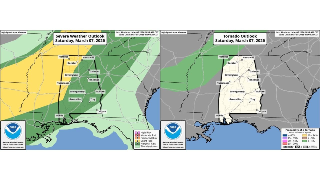
The updated Storm Prediction Center outlook for Saturday, March 7, 2026, places portions of northwest Alabama within a marginal severe weather risk area, indicating that a few storms could briefly become strong.
Cities including Florence, Huntsville, Decatur, Birmingham, Tuscaloosa, and surrounding communities may experience brief periods of heavy rain, lightning, and gusty winds as storms pass through.
However, forecasters emphasize that widespread severe weather is not expected with this system.
Tornado Risk Across Alabama Remains Very Low
Forecast maps from the Storm Prediction Center tornado outlook show that the probability of tornado development across Alabama is extremely limited with this storm system.
While the environment may support thunderstorms capable of producing gusty winds or hail, the atmospheric conditions needed for tornado formation appear largely absent.
Meteorologists say wind patterns and instability levels across Alabama today are not favorable for strong tornado-producing storms, which is why the tornado threat remains minimal.
Residents across the state should still remain weather-aware, but the current forecast suggests the majority of storms will remain below severe thresholds.
Storms Expected to Weaken Overnight
As the system continues moving south through Alabama during the late evening and overnight hours, the air mass across the region is expected to become more stable, causing storms to weaken.
By late tonight, most of the thunderstorms should transition into lighter rain showers across southern Alabama and the Gulf Coast region.
While isolated gusty winds may still occur in the strongest storms early in the evening, the overall severe weather threat is expected to diminish overnight.
Residents across Alabama, particularly in the northwest portion of the state, should remain alert for weather updates as storms approach later today.
As conditions evolve throughout the afternoon and evening, ChicagoMusicGuide.com will continue monitoring storm activity and provide updates on thunderstorms, severe weather alerts, and changing forecasts across Alabama and the southeastern United States.