
Alaska’s Katalla and Chugach Coast Slammed by Rare Tropical-Style Polar Low Packing 49 MPH Winds and Symmetric Snow Bands
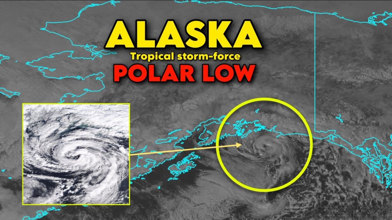
ALASKA, UNITED STATES — Satellite imagery on Wednesday revealed a stunning sight over the Gulf of Alaska: a compact cyclone with a defined eye-like center and spiral bands that looked more like a tropical storm than a typical Arctic system.
The storm made landfall near Katalla in the Chugach Census Area, and meteorologists are calling it one of the most spectacular examples of a polar low seen in recent memory.
A Tropical Look in a Bitter-Cold Setting
From space, the storm displayed:
- A tightly wound circulation
- A visible eye or eye-like feature at its center
- Symmetric spiral snow bands wrapping around the core
Radar data confirmed organized, curved snow bands rotating around the center — a structure remarkably similar to a tropical cyclone, but occurring in frigid Alaskan waters.
Despite the resemblance, this was not a hurricane. It was a polar low, a small but intense low-pressure system that forms over cold ocean waters in high latitudes.
Tropical Storm-Force Winds Recorded
While the region impacted is sparsely populated, wind observations confirm the storm packed serious punch:
- Middleton Island Airport gusted to 49 mph
- Suckling Airport recorded gusts up to 43 mph
Those wind speeds fall within tropical storm-force criteria, underscoring the strength of the compact cyclone.
If this system had struck a densely populated coastline farther south, impacts would have been more significant.
A Rare Warm-Core Structure in Alaska
What makes this event especially notable is its structure.
Most non-tropical storms in high latitudes are “cold-core,” meaning they derive energy from temperature contrasts between air masses. This system, however, developed characteristics of a shallow warm-core cyclone.
Sea surface temperatures in the Gulf of Alaska were estimated around 40–43°F — not warm in absolute terms, but relatively warmer than the bitter cold air mass above.
That relative warmth allowed:
- Air near the ocean surface to become buoyant
- Rising convection to develop near the center
- A compact, organized circulation to strengthen
This contrast created a bubble of relative warmth in the core, mimicking processes seen in tropical systems.
Deep Snow Bands Wrapped the Center
Instead of thunderstorms and heavy rain, this storm featured:
- Intense snow showers
- Convective snow bursts
- Tight, spiral snow bands
These snow bands rotated symmetrically around the eye-like center, adding to the tropical appearance on satellite imagery.
Such well-organized polar lows are uncommon, especially with this level of structural symmetry.
Why This Event Stands Out
Polar lows occur periodically in northern waters, but several factors made this one exceptional:
- Clear eye-like structure visible from satellite
- Symmetric banding
- Tropical storm-force wind gusts
- Shallow warm-core characteristics
Meteorologists note that this may be one of the most visually striking polar lows observed in recent years.
Impacts Limited but Meteorologically Significant
Because the storm tracked near the remote community of Katalla and sparsely populated coastal areas, widespread damage reports have not surfaced.
However, from a meteorological perspective, the event serves as a powerful reminder that:
- The atmosphere can produce tropical-like systems even in polar regions
- Relative ocean warmth plays a crucial role
- Compact storms can rapidly intensify over high-latitude waters
A Rare Arctic Storm That Looked Like the Tropics
For many observers scanning satellite imagery, the storm’s structure was almost surreal — a small cyclone spinning with textbook tropical characteristics, but over the icy waters of southern Alaska.
Events like this highlight the dynamic nature of Earth’s atmosphere and how even the coldest regions can briefly resemble the tropics under the right conditions.
Stay with ChicagoMusicGuide.com for continued coverage of unusual and extreme weather events across the United States.