
Arctic Air Blast to Slam Central and Eastern U.S., Bringing 20–30 Degree Temperature Drop and Possible Snow From Oklahoma to the Mid-Atlantic
UNITED STATES — A powerful surge of arctic air is expected to sweep across the Central and Eastern United States this weekend into early next week, sending temperatures plunging by 20 to 30 degrees and raising the possibility of snow showers from Oklahoma to the Mid-Atlantic. While confidence remains moderate on the cold air, forecasters note that any snow development is still uncertain at this stage.
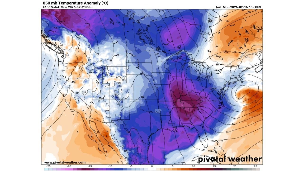
Forecast data valid for Monday, February 23, shows a dramatic temperature anomaly pattern setting up across much of the country. The shift signals one of the more significant late-winter cold shots so far this season.
Arctic Air Mass Targets the Central and Eastern U.S.
Upper-level model guidance indicates a broad zone of well-below-normal temperatures stretching from the Northern Plains through the Midwest and deep into the Southeast. The most intense cold anomalies are projected over parts of the Midwest, Ohio Valley, Tennessee Valley, and Deep South, where temperatures could run 15 to 25 degrees below average.
For cities like Chicago, Illinois, the incoming air mass means a sharp break from recent milder conditions. Residents across Indiana, Ohio, Kentucky, Tennessee, Alabama, and Georgia could also experience the brunt of the cold.
Meanwhile, parts of the Western United States, including areas of California and the Southwest, are forecast to remain closer to or even slightly above average. The contrast between warm air in the West and plunging cold in the Central and Eastern states will help reinforce the sharp temperature gradient across the country.
Snow Potential From Oklahoma to the Mid-Atlantic Remains Uncertain
Along with the cold air, there is early indication of a developing storm system that could track across the southern and eastern portions of the country over the weekend. If the system aligns with the colder air, snow showers could develop from Oklahoma eastward into parts of the Mid-Atlantic.
However, meteorologists caution that the storm track and moisture availability remain uncertain. A slight shift north or south in the system’s path could mean the difference between cold rain, light snow, or minimal precipitation.
Areas to watch include:
- Oklahoma
- Arkansas
- Tennessee
- Kentucky
- Virginia
- Parts of the Mid-Atlantic region
At this time, forecasters emphasize that this is not yet a confirmed winter storm scenario. Instead, it is a developing pattern that bears close monitoring as the weekend approaches.
Temperatures to Fall 20–30 Degrees Early Next Week
The most immediate and widespread impact will be the dramatic temperature drop expected early next week. Much of the Central and Eastern United States could see daytime highs tumble by 20 to 30 degrees compared to recent readings.
In practical terms, that could mean:
- Highs in the 60s dropping back into the 30s or 40s
- Overnight lows dipping well below freezing across the Midwest and parts of the South
- Increased wind chill values making it feel even colder
For Chicago, Illinois, the arrival of the arctic air will likely bring a return to more typical late-February cold, with brisk winds enhancing the chill factor. Travel impacts appear limited at this time, but rapidly falling temperatures can lead to slick spots if any precipitation develops.
A Late-Winter Reminder for the Midwest and East
While the calendar edges toward spring, this setup is a reminder that winter patterns can quickly reassert themselves across the Midwest and Eastern United States. The phrase circulating among weather watchers — “the groundhog might not be fired after all” — reflects the idea that colder weather may linger longer than some had hoped.
The key takeaway remains the significant cold surge rather than guaranteed snowfall. Forecast updates over the next several days will refine the track and intensity of the potential storm system.
As the arctic air mass settles in, residents across Chicago, Illinois, the broader Midwest, and the Eastern states should prepare for a noticeable temperature shock and stay tuned for updates regarding any developing snow chances.
As this late-winter cold pattern unfolds across the Central and Eastern United States, staying informed will be essential. For continued updates on Midwest weather patterns, storm developments, and seasonal outlooks affecting Illinois and beyond, visit ChicagoMusicGuide.com.