
Arctic Blast to Drive Wind Chills Down to –20 to –35 Degrees Across the Upper Midwest as Record-Breaking Cold Intensifies
UPPER MIDWEST — A powerful Arctic blast is surging across the region, bringing some of the coldest temperatures of the season and pushing wind chills into the dangerous –20 to –35 degree range. This mass of frigid air is expected to break several early-winter records from Minnesota to Michigan, while also stretching south into northern Illinois, Wisconsin, Indiana, and Ohio.
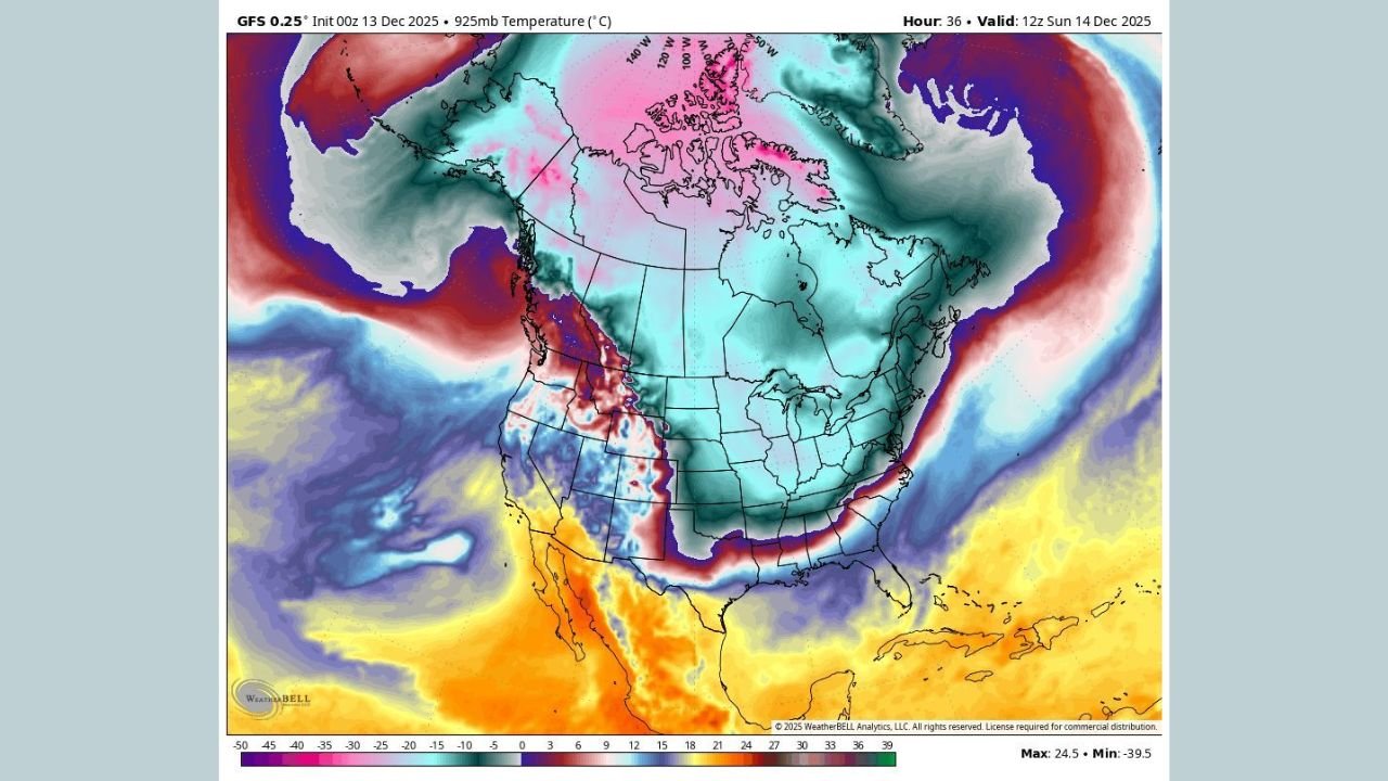
Record-Breaking Cold Takes Aim at Minnesota, Wisconsin, and Michigan
Meteorological models show the cold core of the Arctic air mass centered over the Upper Midwest, with the most extreme temperature drops forecast in:
- Northern Minnesota
- Northern Wisconsin
- Upper and Lower Michigan
These areas are highlighted in the model as the deepest shades of purple and blue, indicating:
- Subzero temperatures
- Widespread overnight lows well below 0°F
- Severe wind chills into Sunday morning
This section of the Midwest will face the highest frostbite risk, with exposed skin potentially freezing in under 10 minutes.
Wind Chills of –20 to –35 Degrees Expected Across Multiple States
The dangerous cold extends beyond the northern tier, affecting major population centers across:
- Illinois (including Chicago)
- Indiana
- Ohio
Wind chills in these areas are projected to fall between –20 and –30 degrees, with several counties flirting with readings as low as –35 degrees.
Such conditions can quickly overwhelm the body’s ability to regulate heat, and forecasters warn that:
- Pets should not be left outside
- Homes should be monitored for frozen pipes
- Residents should limit outdoor exposure
The rapid onset of cold could challenge local utilities and increase emergency call volumes.
Why This Arctic Surge Is So Intense
According to the atmospheric model, the Arctic blast originates from deep within northern Canada, where temperatures have been exceptionally cold. A southward dip in the jet stream is allowing this air to spill directly into the Great Lakes and Midwest, creating:
- Sharp temperature drops
- Dangerous early-morning lows
- Widespread frostbite concerns
- Potential record-setting cold readings
The map highlights a dramatic contrast between warm southwestern states and the bitter cold gripping the Midwest — emphasizing the sharp boundary driving the Arctic outbreak.
Cold Expected to Last Through Early Next Week
The Arctic air mass is not expected to retreat quickly. Residents across the Upper Midwest should prepare for:
- Multiple days of subfreezing temperatures
- Single-digit daytime highs
- Continuing hazardous wind chills
- Icy travel conditions
Meteorologists note that extreme cold events of this scale, especially early in the winter season, can strain heating systems and increase risks for vulnerable households.
Stay Safe and Stay Updated With ChicagoMusicGuide.com
As this Arctic blast continues to grip the Midwest with dangerous wind chills, remember to prioritize safety and protect those around you.
For more weather alerts, cold-weather tips, and regional updates, keep following ChicagoMusicGuide.com.