
Arctic Blast to Hit Virginia, Maryland, and Washington D.C. as Weekend Storm Brings Snow and Temperatures 20–30 Degrees Below Normal Across the Mid-Atlantic
VIRGINIA — Mid-Atlantic Prepares for Two Rounds of Snow Followed by a Major Arctic Outbreak, Residents across Virginia, Maryland, and Washington D.C. are preparing for a high-impact winter weekend, as two storm systems and a powerful Arctic air mass combine to bring snow, plunging temperatures, and dangerous wind chills to the Mid-Atlantic region.
Forecast models and new meteorological analysis show the region entering a two-stage winter event:
- A Friday clipper system bringing light snow, and
- A stronger weekend storm capable of producing widespread accumulating snow before Arctic air floods the region.
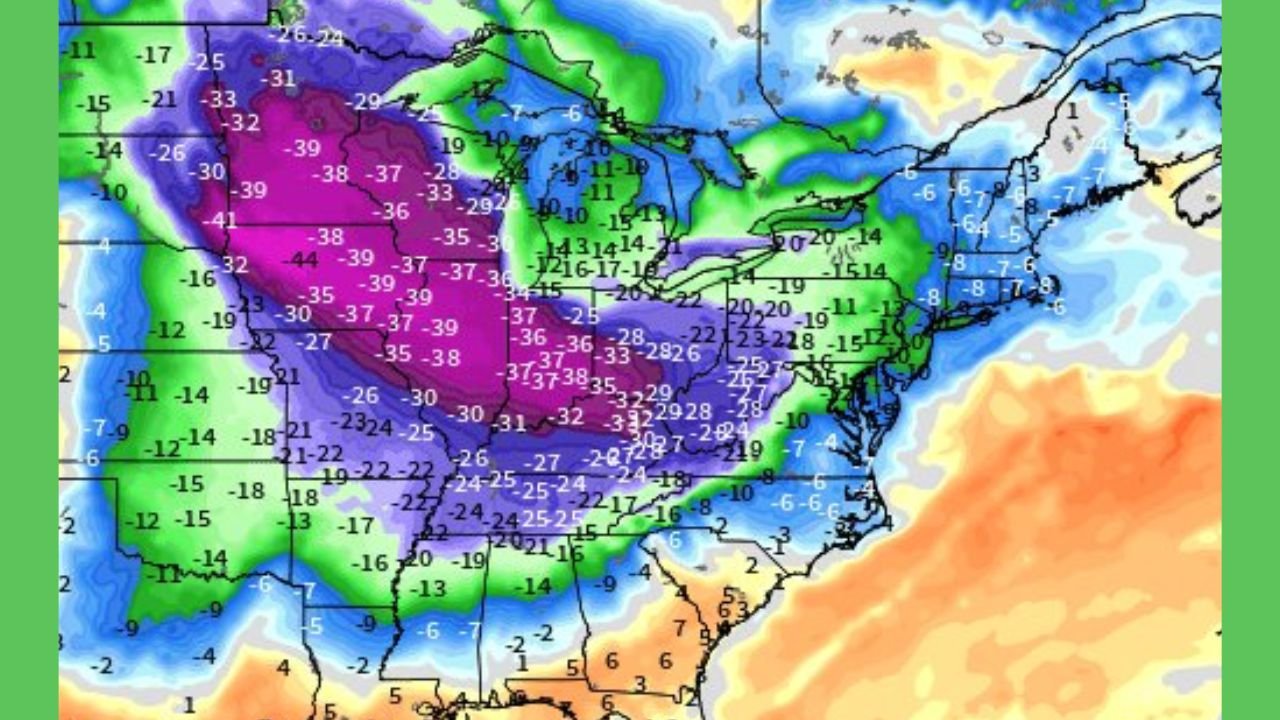
ECMWF Models Show Sharp Temperature Drop Across the Mid-Atlantic
According to the ECMWF 06Z model:
- The Mid-Atlantic will experience temperature departures of –15°F to –25°F below normal by Sunday night.
- This places Virginia, Maryland, and D.C. beneath the leading edge of a powerful Arctic air mass descending from the Upper Midwest.
- The temperature gradient is striking—while the West warms to 10–20 degrees above normal, the Mid-Atlantic undergoes a full pattern reversal into deep winter cold.
Highs in many areas may not reach above the 20s or low 30s, with wind chills falling into the teens and single digits.
Friday Clipper System: Light Snow but Slick Travel
A weakening Alberta clipper arrives Friday morning and continues through the afternoon, bringing:
- Light accumulations of 0.5–2 inches
- Most snow falling across northern Virginia, the District, and central/northern Maryland
- Patchy slick roads, especially during the peak commute
- Reduced visibility in fast-moving snow bands
Although snowfall totals remain modest, the powdery nature of the snow means even small amounts could cause travel delays.
Weekend Storm: Stronger System May Bring Wider Snow Coverage
Meteorologist Paul Dorian identifies the weekend system as “the most impressive” of the pattern — one that will tap into greater moisture and interact directly with approaching Arctic air.
Expected impacts across Virginia, Maryland, and D.C. include:
• Widespread Snowfall
Forecast models support:
- 2–5 inches across the D.C. metro and northern Virginia
- 3–6+ inches possible in parts of Maryland
- Higher totals in the Blue Ridge and western Maryland mountains
• Rapid Temperature Crash
Temperatures fall quickly behind the departing storm, creating:
- Instant freezing of wet roads
- Increased black ice risk overnight
- Hazardous travel conditions lasting into early next week
• Intensified Winds
Gusts may contribute to:
- Blowing snow
- Reduced visibility
- Bitter wind chills across the region
Arctic Outbreak Arrives Sunday Into Monday
The true Arctic air mass arrives immediately after the weekend snowfall.
Projected Conditions:
- Lows in the teens across the D.C. metro
- Single-digit lows possible in western Maryland and higher elevations of Virginia
- Wind chills between 0°F and –10°F
- Coldest Mid-Atlantic stretch so far this winter season
This cold wave is early for mid-December and may challenge infrastructure, school operations, and regional travel.
Virginia: Sharp Cold and Snowfall Likely Across the Northern Half of the State
Northern Virginia — including Fairfax, Loudoun, and Arlington counties — will see:
- Friday light snow
- Weekend totals between 2–5 inches
- Wind chills near 0–5°F Sunday night
Western and mountainous Virginia may see heavier snow due to elevation effects.
Maryland: Higher Snow Totals Possible in Central and Northern Regions
Maryland stands to receive some of the highest snow totals in the region:
- 3–6 inches likely in central counties
- More than 6 inches possible in western Maryland
- Very cold temperatures moving in quickly behind the storm
Baltimore and the surrounding suburbs should prepare for slick travel and rapid icing after snowfall.
Washington D.C.: Two-Phase Snow Event With Bitter Cold Behind It
The nation’s capital will likely experience:
- A Friday coating of snow
- A Saturday night/Sunday morning accumulation
- A winter pattern shift resulting in the coldest air of December so far
Wind chills in D.C. may fall into the upper single digits by Monday morning.
Why This Mid-Atlantic Event Is Significant
This pattern stands out because:
- It features multiple snow-producing systems
- Cold air arrives immediately after the weekend storm
- Temperature anomalies of –15 to –25 degrees are unusually strong for early December
- The shift could signal a colder trend for the remainder of the month
The Mid-Atlantic often sits on the boundary between warm and cold air — but this outbreak pushes the region decisively into winter.
Residents Encouraged to Prepare Early
Forecasters advise residents across VA, MD, and D.C. to:
- Monitor updated forecasts
- Limit travel during heavier weekend snow
- Protect pipes and exposed plumbing
- Prepare for long-duration cold
- Allow extra time for Monday morning commutes
Stay Updated With ChicagoMusicGuide.com
For more winter weather coverage across the United States — including storm tracking, temperature forecasts, and regional updates — continue following ChicagoMusicGuide.com.