
Arctic Front Brings Snow, Dangerous Wind Chills, and Power Outage Risk Across New York, Pennsylvania, New England, and the Mid-Atlantic This Weekend
UNITED STATES — A powerful Arctic front is set to sweep across the Northeast and Mid-Atlantic this weekend, bringing accumulating snowfall, dangerously low wind chills, and gusty winds from Friday night through Saturday, followed by the coldest air of the season for many states.
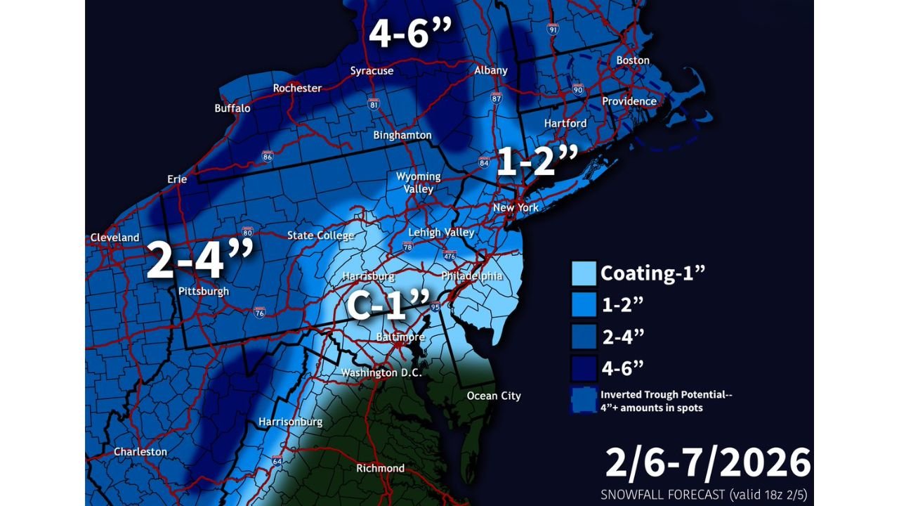
Forecast models show a complex and narrow snowfall setup, with several regions at risk for plowable snow totals, particularly across New York, Pennsylvania, Vermont, Massachusetts, Connecticut, and Rhode Island. While exact placement of heavier bands remains uncertain, confidence is growing that Friday night and Saturday will be harsh regardless of snowfall totals.
Snowfall Setup: Narrow Bands Could Deliver Plowable Snow
High-resolution guidance, including RRFS experimental models, indicates the potential development of an inverted trough (IVT) along the leading edge of the Arctic front. Where this feature sets up, snowfall rates could briefly intensify, producing localized totals of 3–6 inches in a very narrow corridor.
Current projections highlight three main zones to watch:
- Vermont: Especially central and western areas, where 1–3 inches is common, with localized enhancement possible.
- Massachusetts Coast (including Boston): Coastal convergence could support 3–5 inches, particularly on Cape Cod and nearby coastal communities.
- Southern New England Inverted Trough Zone: Areas between Hartford, Connecticut and Boston, Massachusetts could see isolated totals exceeding 4 inches, with a few locations approaching 6 inches if banding persists.
Because this setup is highly sensitive, small shifts will significantly change who sees the highest totals.
Regional Snow Totals by State
New York
- Western & Central NY: General 2–4 inches, with lake enhancement pushing totals over 4 inches near Lake Ontario.
- Upstate NY (including Syracuse region): 4–6 inches possible.
- NYC & Long Island: Mainly 1–2 inches, with some areas seeing just a coating.
Pennsylvania
- Western Pennsylvania: Widespread 2–4 inches, including the Pittsburgh area.
- Eastern & Higher Elevations: Mostly 1–2 inches, locally higher in elevated terrain.
- Central Pennsylvania: Snow tapers southward, with lighter totals toward Harrisburg.
New England
- Vermont & New Hampshire: 1–3 inches, locally higher in favored terrain.
- Massachusetts & Rhode Island: 3–5 inches possible near the coast, with lighter amounts inland.
- Maine: Northern areas may only see a trace to 1 inch.
Mid-Atlantic
- Maryland & Washington, D.C.: Mainly a coating to 1 inch, but wind will be the bigger issue.
- Virginia: Limited snowfall, but sharp temperature drops follow.
Wind and Arctic Cold: The Bigger Threat
Regardless of snowfall totals, the cold will be the dominant and dangerous story.
- Saturday highs: Only 20–25°F across much of the Northeast and Mid-Atlantic.
- Nighttime lows: Dropping into the teens and single digits, with some areas near 0°F.
- Wind gusts: 40–50 mph possible Saturday, especially in exposed areas.
These winds will drive wind chills well below zero, with values ranging from -10°F to -20°F, and isolated spots near -30°F. Early Sunday morning, it could feel like -5°F or colder around Washington, D.C.
Power Outage and Travel Concerns
The combination of light snow, blowing snow, and strong winds may significantly reduce visibility at times, especially Friday night into Saturday morning. While snow amounts alone may not be crippling everywhere, gusty winds raise the risk of scattered power outages, particularly where snow accumulates on trees and power lines.
Travel conditions may rapidly deteriorate during bursts of snow and blowing snow, especially in New York, Pennsylvania, and southern New England.
Looking Ahead: Another Winter Storm Possible Next Week
Forecast confidence is increasing that a larger storm system could impact the Eastern United States between February 11–14, potentially ending the current dry stretch. Details remain uncertain, but winter weather impacts are possible across multiple states.
Bottom Line
This weekend will bring light to moderate snowfall, but brutal cold, dangerous wind chills, and strong winds will make Friday night and Saturday particularly rough across much of the Northeast and Mid-Atlantic. Even areas with minimal snow should prepare for dangerous cold exposure and possible power disruptions.
Stay warm, limit exposure, and monitor updates as the exact snow bands become clearer.
For ongoing winter weather updates, regional forecasts, and storm breakdowns, keep following Chicagomusicguide.com.