
Arctic Front Slams the East Coast With Brutal Cold, Dangerous Winds, and Targeted Snow Bands From Friday Night Through Saturday
UNITED STATES — A powerful Arctic air mass is plunging south out of Canada late Friday, setting up what forecasters are calling one of the harshest 24-hour stretches of winter so far, with extreme cold, damaging wind gusts, and scattered snow squalls impacting large portions of the Mid-Atlantic and Northeast through Saturday.
The setup is driven by a Siberian-origin Arctic front that tracks from Severny Island in the Arctic on January 29 all the way into the Washington, D.C. region by February 7, delivering a rapid temperature collapse and dangerous wind chills across multiple states.
Arctic Air Mass Path Shows Direct Siberian Connection
Forecast graphics clearly trace the air mass from the high Arctic southward through central Canada and into the eastern United States, confirming this is not a typical cold front.
This direct Arctic delivery explains:
- The speed of the temperature drop
- The severity of wind chills
- The widespread nature of cold alerts
Once the front arrives late Friday, conditions deteriorate rapidly overnight.
Snow Showers and Squalls Develop Ahead of the Front Friday Afternoon
Radar guidance shows scattered snow showers developing Friday afternoon into early evening, particularly:
- West of Washington, D.C.
- Across parts of Virginia, Maryland, and Pennsylvania
These snow showers will be hit-or-miss, but could:
- Briefly reduce visibility
- Create slick travel conditions
- Leave quick coatings of snow in localized spots
While snow amounts are generally light at this stage, timing overlaps with the Friday evening commute, increasing impact.
Winds Ramp Up Overnight With Gusts Exceeding 50 MPH
As the Arctic front pushes through late Friday night into Saturday morning, winds rapidly intensify.
Forecast wind maps show:
- 35+ mph gusts across much of the Mid-Atlantic
- 40–50 mph gusts near the Chesapeake Bay
- 50+ mph gusts in mountain zones west of the Blue Ridge
These winds raise concerns for:
- Power outages
- Downed tree limbs
- Blowing and drifting snow where snow showers occur
Wind advisories are likely, with high wind warnings probable in mountainous areas.
Extreme Cold Takes Hold Saturday Morning Into Sunday
Once the front passes, brutal cold follows immediately.
Temperature forecasts indicate:
- Actual air temperatures falling into the teens by Saturday morning
- Struggling to rise out of the low 20s during the day
- Overnight lows dropping to 5–10 degrees Saturday night
The bigger threat comes from wind chills.
Wind Chills Drop Below Zero With Dangerous Exposure Risk
Extreme cold products are already posted across the region, with alerts in effect from 4 AM Saturday through 10 AM Sunday.
Forecast wind chills include:
- 0 to -10°F east of the Blue Ridge
- -10 to -25°F west of the Blue Ridge
- -20 to -30°F in the Alleghany Front and Blue Ridge Mountains
Some areas may experience near- or below-zero wind chills for nearly 24 straight hours, especially from Saturday into early Sunday.
Forecasters warn:
- Frostbite can occur in minutes
- Hypothermia risk is high if skin is exposed
- Proper layering is critical
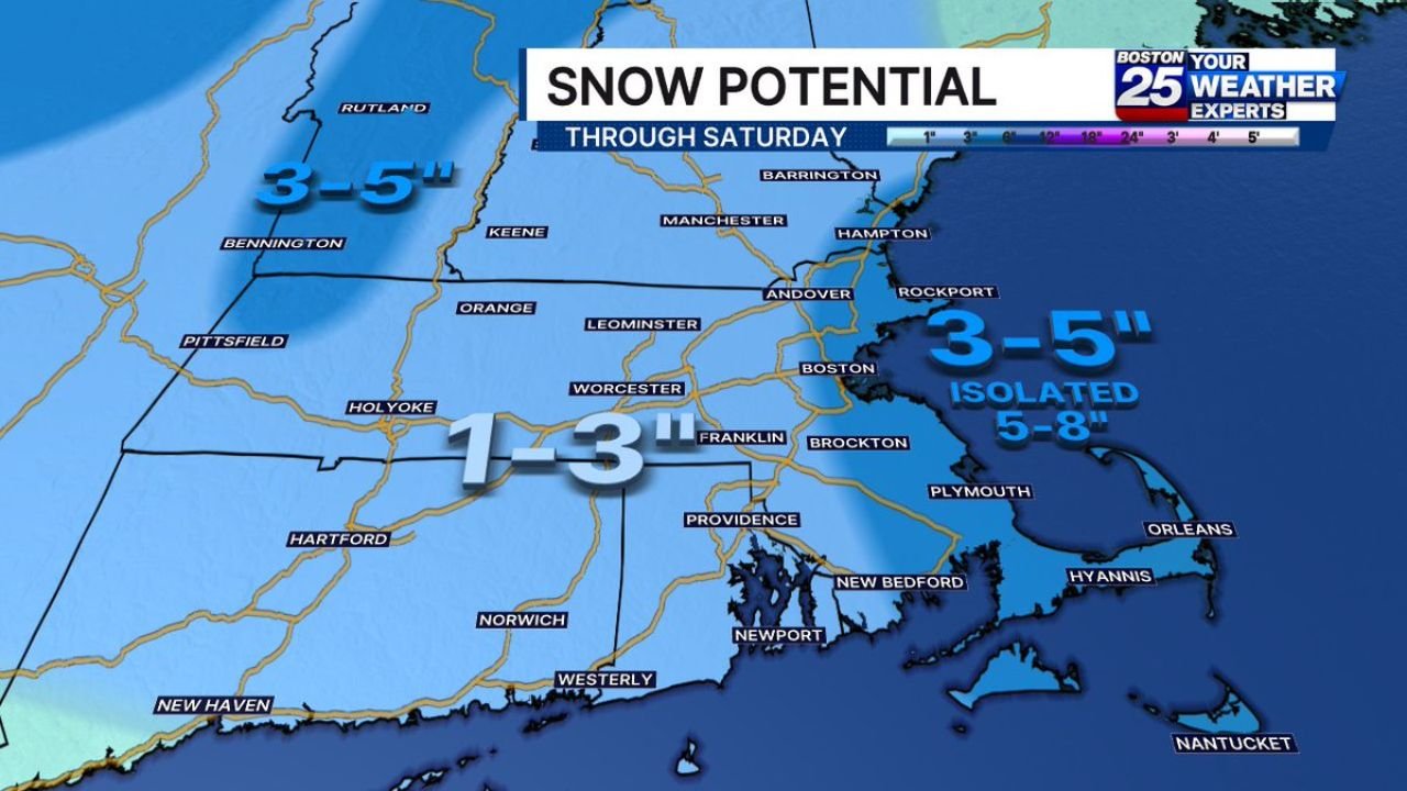
Eastern Massachusetts Faces Isolated Heavy Snow Bands Saturday
While most of the region sees light snow, Eastern Massachusetts stands out for a different reason.
Snow potential maps show:
- 1–3 inches for most locations
- 3–5 inches across parts of Eastern Mass
- Isolated 5–8 inch totals in very narrow, intense snow bands
These bands will be highly localized, meaning only a small number of towns see heavy snow, while nearby communities receive much less.
Forecasters emphasize that wind will blow snow aggressively, reducing the importance of exact totals.
Rochester and Western New York See Blowing Snow and Bitter Cold
Forecast timelines for the Rochester area show:
- Friday evening: Burst of heavy snow as the Arctic front arrives
- Late Friday night: Rapid temperature plunge with accumulating snow
- Saturday: Dangerous cold with scattered lake flakes
- Wind chills feeling as cold as -25°F early Saturday
Even areas receiving only 1–3 inches of snow will see significant impacts due to blowing and drifting.
The Bottom Line: A Dangerous 24 Hours of Winter Weather
Meteorologists stress that exact snow totals are not the story with this system.
The real threat is the combination of extreme cold, strong winds, and blowing snow, creating:
- Hazardous travel
- Power outage risks
- Serious health concerns for anyone outdoors
Whether alerts are upgraded or not, Friday night through Saturday will be bitterly cold, windy, and dangerous across much of the East.
How cold is it where you are this weekend — and are you seeing snow or just brutal wind chills? Share your local conditions and stay weather-aware with ChicagoMusicGuide.com, where we track major weather impacts affecting travel, events, and daily life nationwide.