
Arctic Outbreak to Slam Minnesota, Wisconsin, and Michigan as Temperature Anomalies Plunge 30–40 Degrees Below Normal Across the Great Lakes
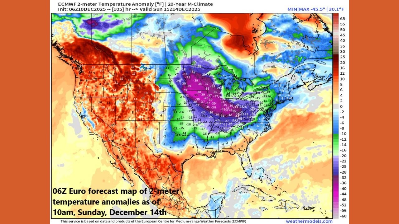
MINNESOTA — Upper Midwest and Great Lakes Brace for One of the Coldest December Weekends in Years, A major Arctic blast is set to sweep across the Upper Midwest and Great Lakes region this weekend, pushing temperatures in Minnesota, Wisconsin, and Michigan to levels 30–40 degrees below normal, according to the latest ECMWF 06Z model analysis.
The cold outbreak arrives as several fast-moving Alberta clipper systems track across the northern United States, bringing bursts of snow, high winds, and rapid temperature drops from the Dakotas to northern Michigan.
ECMWF Model Shows Core of the Cold Centered on Minnesota and Wisconsin
Sunday’s ECMWF temperature anomaly map highlights the Upper Midwest as the epicenter of the coldest air mass in the continental U.S.:
- Minnesota shows widespread anomalies of –30°F to –38°F below average, especially northern and central regions.
- Wisconsin appears entirely engulfed in deep purple and blue temperature shading, signaling extreme departures below normal.
- Michigan’s Upper Peninsula and northern Lower Peninsula show anomalies between –25°F and –35°F below normal, confirming a major early-season cold outbreak.
Daytime highs may struggle to rise above 0°F in northern Minnesota, while single-digit highs are likely across Wisconsin and Michigan.
Wind chills may fall as low as –25°F to –35°F, raising concerns for frostbite and dangerous outdoor conditions.
Clipper Systems Bring Snow and Reinforce the Arctic Air
Meteorologist Paul Dorian describes the incoming pattern as a “major-league Arctic blast,” driven by a sequence of disturbances across the northern tier.
• First Clipper — Light Snow and Blowing Snow
A Thursday–Friday clipper system brings:
- 1–3 inches of light, powdery snow across Minnesota and Wisconsin
- Blowing snow and reduced visibility due to strong northwest winds
- Quick freeze-ups on untreated roads
• Weekend Clipper — More Organized System
The second system late Saturday into Sunday is expected to be:
- Stronger
- Better organized
- More impactful for the Great Lakes
This clipper could deliver:
- 2–5 inches of snow across northern Wisconsin, the U.P. of Michigan, and parts of Minnesota
- Enhanced snowfall from Lake Superior lake-effect bands
- A rapid crash in temperatures behind the system
Minnesota Forecast: Deep Freeze and Hazardous Wind Chills
Minnesota remains the center of the coldest anomalies.
Residents should expect:
- Highs near –5°F to 5°F depending on location
- Overnight lows near –15°F to –25°F
- Wind chills plunging to –30°F or colder
- Light snow Thursday and Saturday, with blowing snow hazards
Northern Minnesota could experience dangerous cold conditions normally seen in late January, not mid-December.
Wisconsin Forecast: Snow Bursts and Weekend Arctic Shock
Wisconsin will experience:
- Light snow with each clipper system
- Higher totals (2–4 inches) in northern counties
- Daytime highs in the single digits
- Overnight lows around –10°F to –20°F
- Arctic wind chills in the –20°F to –30°F range
Madison, Milwaukee, and Green Bay all face significant cold impacts.
Michigan Forecast: Lake-Effect Snow and Bitter Air
Michigan — particularly the U.P. and northwestern Lower Peninsula — will see:
• Lake-Effect Snow
Lake Superior’s cold air interaction will produce:
- Localized intense snow bands
- Reduced visibility
- Travel hazards into Sunday
• Arctic Temperatures
Northern Michigan temperatures will run:
- 25–35 degrees below normal
- Highs in the single digits
- Lows near –5°F to –15°F
Wind chills could drop into the –20°F to –25°F range.
Why This Arctic Outbreak Is So Significant
This cold wave stands out because of:
- Intensity — 30–40°F anomalies are rare for early December
- Coverage — cold spans from the Dakotas through the Great Lakes to the East Coast
- Reinforcement mechanisms — multiple clipper systems transporting continuous cold air
- Longevity — the pattern may persist through much of next week
The temperature contrast across the country is also remarkable: the western U.S. shows 10–20°F above normal, while the Upper Midwest freezes under extreme cold.
Residents Urged to Prepare for Severe and Prolonged Cold
State officials and forecasters across Minnesota, Wisconsin, and Michigan advise:
- Avoid extended outdoor exposure
- Prepare vehicles for subzero conditions
- Check heating systems and insulation
- Allow extra travel time during clipper snow events
- Monitor for frostbite and hypothermia risks
Stay Updated With ChicagoMusicGuide.com
For more winter weather coverage across the U.S. — including storm tracking, Arctic blast updates, and regional forecasts — continue following ChicagoMusicGuide.com.