
Arkansas Faces Dangerous Arctic Air Surge With Subzero Wind Chills Possible Saturday Morning, January 31
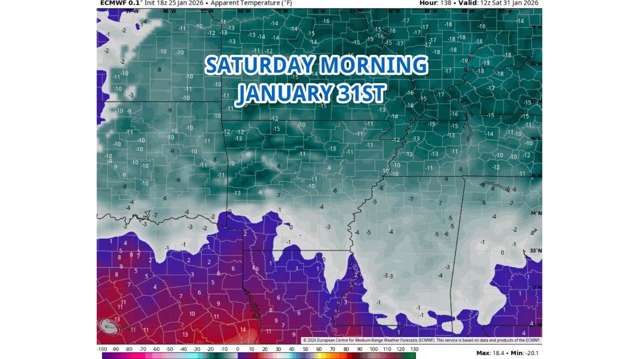
ARKANSAS — A fresh surge of arctic air is expected to push into the state late this week, setting the stage for dangerously cold wind chills across Arkansas early Saturday morning, January 31, according to the latest European (ECMWF) model data. Forecast guidance shows apparent temperatures plunging well below zero, even in areas that may not see additional snowfall.
While this system is not expected to be a major snow producer, the cold itself will be the primary hazard, with conditions becoming harsh and potentially dangerous by daybreak Saturday.
ECMWF Model Signals Serious Cold Across Arkansas
The ECMWF apparent temperature map highlights widespread subzero wind chills across much of northern and central Arkansas, with values dropping into the -10°F to -20°F range in exposed areas. These readings factor in both temperature and wind, meaning frostbite can occur quickly for anyone outdoors without proper protection.
Southern parts of the state are expected to remain slightly less extreme but still bitterly cold, with wind chills hovering in the single digits to near zero.
Timing: Coldest Conditions Early Saturday Morning
Forecast timing places the coldest wind chills around sunrise Saturday, when overnight radiational cooling combines with lingering northwest winds behind the arctic front. Conditions may improve slowly later in the day, but dangerous cold will persist through much of Saturday, especially in shaded and rural areas.
Even brief exposure during the early morning hours could be hazardous, particularly for those heading to work, outdoor chores, or travel.
Small Chance for Flurries or Light Snow Showers
At this time, model guidance suggests only a limited chance for a few flurries or light snow showers across parts of Arkansas. Any precipitation that does occur is expected to be light and spotty, with little to no accumulation. However, even minimal snowfall could contribute to slick spots, especially on untreated roads as temperatures plunge.
Cold Impacts Extend Beyond Snow
Officials and forecasters emphasize that cold-related impacts may outweigh snow impacts with this system. Prolonged exposure to extreme wind chills can stress infrastructure, increase heating demand, and pose risks to pets, livestock, and vulnerable populations.
Residents are encouraged to layer up, limit time outdoors, and ensure adequate heating, especially overnight Friday into Saturday morning.
For continued updates on Arkansas winter weather, arctic air outbreaks, and wind chill forecasts, stay connected with ChicagoMusicGuide.com for the latest developments as this cold surge approaches.