
Arkansas, Missouri, Oklahoma, Kentucky, Tennessee, West Virginia, Virginia, North Carolina and Maryland Face Major January Winter Storm With Heavy Snow, Dangerous Ice and Widespread Travel Disruptions
UNITED STATES — A large, long-lasting, and highly disruptive winter storm is forecast to impact a broad swath of the central, southern, and eastern United States beginning Friday and continuing through early next week, according to the latest guidance and key messages tied to this storm system. The event has the potential to become one of the most significant January winter storms in many years, bringing heavy snow, treacherous ice, and prolonged cold across multiple states.
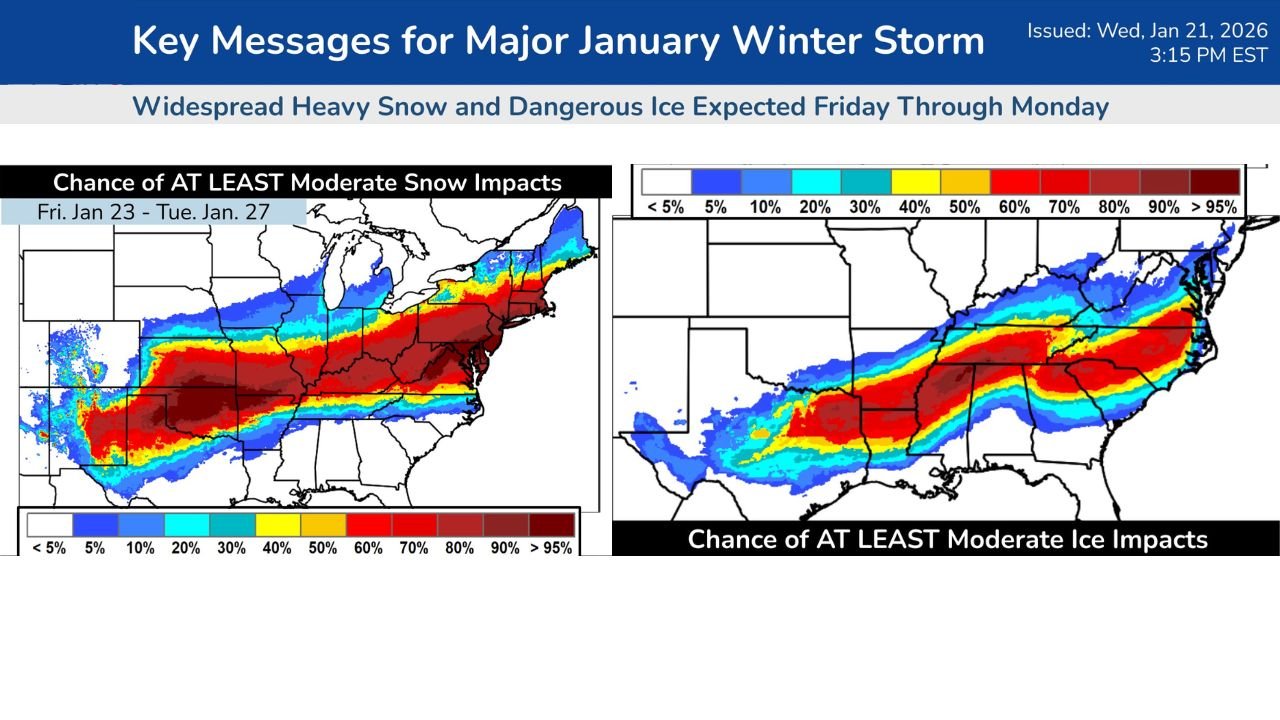
The storm is expected to stretch from the Southern Plains and Mid-South into the Ohio Valley, Appalachians, Mid-Atlantic, and eventually the Northeast, affecting millions of people and creating major travel and infrastructure challenges.
Winter Storm Watch Expanded Across Central and Eastern States
Winter Storm Watches now cover large portions of:
- Oklahoma
- Arkansas
- Missouri
- Kentucky
- Tennessee
- West Virginia
- Virginia
- North Carolina
- Maryland
These watches signal a high likelihood of impactful winter weather, even though exact snowfall and ice totals are still being refined.
Heavy Snow Threat: Widespread and Potentially Significant
Forecast probability maps show a high chance of at least 3 inches of snowfall across a wide corridor extending from the Southern Plains through the Mid-South and into the Mid-Atlantic.
Key concerns include:
- A broad swath of moderate to heavy snow affecting Oklahoma, northern Arkansas, Missouri, Kentucky, and Tennessee
- Snow spreading east into West Virginia, Virginia, Maryland, and parts of North Carolina
- Localized totals exceeding 8–12 inches possible where snow bands persist
- Reduced visibility and snow-covered roads, leading to widespread travel disruptions
Snow may linger in some areas into Monday, especially as colder air settles in behind the storm.
Dangerous Ice Zone South of the Snow Line
One of the most serious threats with this storm is freezing rain and sleet, particularly south of the main snow band.
Ice risk is highest across:
- Southern Arkansas
- Western and central Tennessee
- Parts of Kentucky
- Western and central North Carolina
- Portions of Virginia
Probability maps indicate a strong chance of at least 0.05 inches of freezing rain, with some locations potentially seeing higher amounts.
Impacts may include:
- Extremely slick roads and bridges
- Tree damage from ice accumulation
- Prolonged power outages
- Dangerous conditions for emergency response
Lengthy and Disruptive Storm Timeline
This is not a fast-moving system. The storm is expected to:
- Begin Friday in the Southern Plains
- Intensify and expand eastward through the weekend
- Linger into early next week in the Mid-Atlantic and Northeast
- Be followed by significant cold, which may prolong snow and ice impacts
The extended duration raises concerns for compounding impacts, including repeated rounds of hazardous travel and slow recovery.
Forecast Uncertainty Still Exists — But Confidence Is High in Impacts
While meteorologists note ongoing model differences regarding exact storm track and precipitation totals, confidence is very high that a major winter storm will occur.
More precise snowfall and ice accumulation forecasts are expected as the system approaches and additional data becomes available.
What Residents Should Do Now
If you are under a Winter Storm Watch, this is the time to prepare:
- Avoid unnecessary travel during the storm
- Prepare for possible power outages
- Stock up on essentials, medications, and heating supplies
- Have a winter safety plan for pets and vulnerable family members
This developing winter storm has the potential to disrupt travel, utilities, and daily life across a massive portion of the country. Additional updates will be critical as the storm evolves.
Stay alert, stay prepared, and continue following updates as conditions become clearer.
For continued winter weather coverage, stay with ChicagoMusicGuide.com.