
Arkansas, Oklahoma and Missouri Face Overnight Storm Push as Strong Thunderstorms Develop in Southern Arkansas and Move East Late Friday
ARKANSAS — A developing storm system across southern Arkansas and Oklahoma is expected to push eastward overnight into early Saturday, bringing rain, gusty winds, and isolated strong storms across much of the region. While the overall severe threat remains limited, some areas could still experience brief heavy downpours, lightning, and small hail as storms organize and move through.
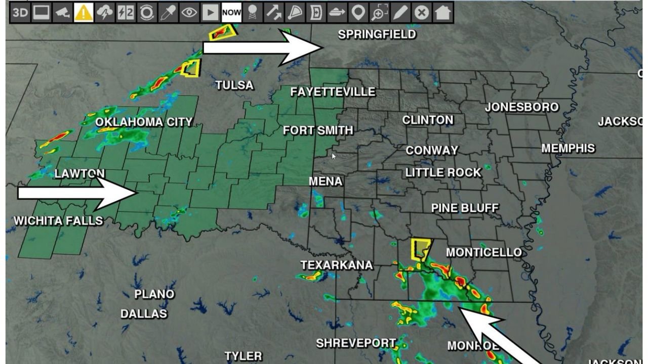
Storm Development Ongoing Across Oklahoma and Southern Arkansas
Current radar trends show active thunderstorm development across Oklahoma, with storms gradually organizing and tracking east toward western Arkansas. At the same time, southern Arkansas, especially near areas like Texarkana and Monticello, is already seeing stronger storm activity, where hail and gusty winds have been the primary concerns.
These storms are forming in a moderately unstable environment, allowing for pockets of stronger cells, even though widespread severe weather is not expected. The radar also highlights scattered showers and embedded thunderstorms across central Arkansas, signaling a broader rain event underway.
As storms continue to move east, areas including Fort Smith, Fayetteville, and Little Rock could begin to see increasing rain coverage later tonight, with conditions gradually becoming more active after sunset.
Late Night Arrival Expected Across Western and Central Arkansas
Forecast timing suggests that western Arkansas will see the first round of storms late Friday night, with activity spreading eastward into central and eastern parts of the state by early Saturday morning.
Some residents may not experience rainfall until very late overnight hours, which means storms could arrive while most people are asleep. This raises the importance of staying weather-aware, especially in areas where isolated stronger storms could produce loud thunder, brief heavy rain, and gusty winds.
The storms moving into northwest Arkansas from Oklahoma, including near Tulsa and Springfield corridors, may weaken slightly over time, but could still bring periods of steady rain and occasional lightning.
Severe Risk Remains Low but Isolated Strong Storms Possible
Despite the active radar and developing storms, the overall severe weather risk remains low across Arkansas and surrounding areas. However, forecasters note that a few stronger cells, particularly in southern Arkansas, may still produce small hail or brief wind gusts.
The main story with this system is expected to be widespread rainfall, which will benefit areas that have been relatively dry. Many locations across Arkansas could see a steady rain event rather than widespread severe weather, which is considered a positive outcome for drought relief and soil moisture.
Even so, storms described as “noisy and cranky” may still bring frequent lightning and bursts of heavy rain, especially during the overnight period.
A Beneficial Rain Event for Much of Arkansas
This setup appears to favor a beneficial rain event across a large portion of Arkansas, with rainfall spreading from west to east through the overnight hours.
While not extreme, the rainfall will likely be widespread enough to improve ground conditions, especially in areas that have missed out on recent precipitation. The combination of steady rain and embedded thunderstorms will help deliver consistent moisture without significant severe weather disruption.
Residents across Arkansas, eastern Oklahoma, and parts of Missouri should expect a wet start to Saturday, with lingering showers possible into the morning hours.
As always, conditions can change quickly with developing storms, so staying updated through the night will be important.
For more real-time storm updates, regional weather coverage, and detailed forecasts, visit ChicagoMusicGuide.com.