
Arkansas, Tennessee and Kentucky Under Enhanced Level 3 Risk as Pre-Frontal Supercells Target Memphis, Jonesboro and Paducah With Isolated EF2 Tornado Potential
MEMPHIS, TENNESSEE — A dangerous severe weather setup is unfolding across Arkansas, Tennessee, and Kentucky tonight as forecasters warn that discrete rotating supercells may develop ahead of the main squall line, particularly near the Mississippi River corridor.
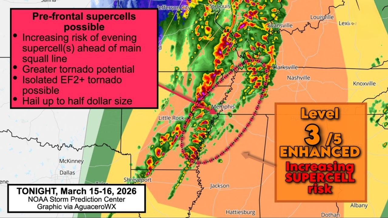
The Storm Prediction Center has outlined a Level 3 out of 5 Enhanced Risk, highlighting an increasing threat of supercells capable of isolated EF2+ tornadoes, damaging winds, and hail up to half-dollar size.
Pre-Frontal Supercells Possible Ahead of Main Line
While a powerful squall line is expected to sweep through later, high-resolution models suggest storms could fire ahead of that line — and that’s where the greater tornado concern lies.
Communities specifically mentioned in the higher-risk zone include:
- Memphis, Tennessee
- Jonesboro, Arkansas
- Paragould, Arkansas
- Paducah, Kentucky
This corridor, especially near and just east of the Mississippi River, may see isolated storms develop in a more favorable environment for rotation.
Unlike a solid line of storms, discrete supercells can:
- Rotate more efficiently
- Produce stronger tornadoes
- Generate larger hail
- Maintain intensity longer
Mississippi River Corridor Maximizes Risk
Forecasters emphasize that the tornado risk will be maximized near the Mississippi River Valley.
That includes areas stretching from:
- Little Rock, Arkansas
- Jonesboro, Arkansas
- Memphis, Tennessee
- Up toward Paducah, Kentucky
If supercells form ahead of the line, they would have access to stronger wind shear and instability before the main squall line overtakes them.
This increases the potential for isolated EF2 or stronger tornadoes, though widespread violent tornadoes are not currently expected.
Hail and Damaging Winds Also Concerns
In addition to tornadoes, these pre-frontal storms could produce:
- Hail up to half-dollar size
- Wind gusts exceeding severe criteria
- Frequent lightning
Later in the evening, the primary threat may transition to a more widespread damaging wind event as the squall line organizes and pushes northeast toward:
- Clarksville, Tennessee
- Western Kentucky
- Southern Illinois
Why This Setup Is Concerning
The Enhanced Risk designation signals a more organized and potentially impactful severe weather episode.
Key ingredients in place include:
- Strong wind shear supportive of storm rotation
- A sharpening cold front
- Sufficient instability across western Tennessee and eastern Arkansas
When discrete supercells develop ahead of a main line, they often pose a greater tornado threat than the line itself.
What Residents Should Do
If you live in Arkansas, western Tennessee, or western Kentucky, especially near the Mississippi River:
- Monitor warnings closely
- Have multiple ways to receive alerts
- Be prepared to move to an interior room on the lowest floor
- Do not wait until the squall line arrives to prepare
Storms may develop quickly ahead of the main line and could produce tornadoes with limited lead time.
ChicagoMusicGuide.com will continue monitoring this evolving severe weather situation as supercell potential increases across the Mid-South and lower Mississippi Valley tonight.