
Atlanta, Charlotte and Raleigh Sit in a Rain “Dead Zone” While Chicago, St. Louis and Detroit Soak Up Heavy April Moisture
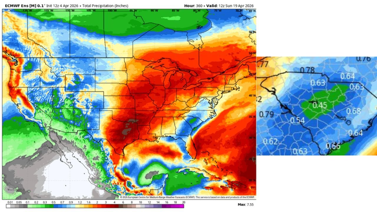
ATLANTA, GEORGIA — A striking and unusual weather pattern is unfolding across the United States, where major Midwest cities like Chicago, St. Louis, and Detroit are positioned for widespread heavy rainfall, while parts of the Southeast including Atlanta, Charlotte, and Raleigh appear locked in a developing dry pocket, creating what forecasters often call a precipitation “dead zone.”
This contrast is not just subtle—it is sharply defined on current model projections, showing deep moisture surging north into the Midwest, while rainfall actively avoids key Southeast corridors despite nearby storm systems.
Midwest Rain Surge Targets Chicago, St. Louis and Detroit
Forecast models indicate a broad corridor of significant precipitation stretching from Texas through the Mississippi Valley into the Great Lakes, directly impacting Chicago, St. Louis, Indianapolis, and Detroit.
This setup suggests:
- Multiple rounds of rain systems tracking northward
- A strong moisture feed from the Gulf of Mexico
- Potential for above-normal rainfall totals over several days
Cities like Chicago and Detroit sit squarely within the deep red shading on precipitation maps, signaling the highest concentration of rainfall accumulation. Meanwhile, St. Louis and surrounding Missouri/Illinois regions may experience repeated storm activity, increasing the risk for localized flooding in vulnerable areas.
This is not a one-off event—rather, it reflects a persistent pattern where storm tracks repeatedly favor the Midwest corridor.
Southeast Dry Slot Forms Over Atlanta, Charlotte and Raleigh
In contrast, a notable dry zone is emerging across parts of the Southeast, particularly over Georgia, South Carolina, and North Carolina.
Cities such as:
- Atlanta, Georgia
- Charlotte, North Carolina
- Raleigh, North Carolina
are shown sitting in a blue-shaded region, indicating lower precipitation totals compared to surrounding areas.
This “gap” occurs because:
- Storm systems are tracking northwest of the region
- Moisture is being pulled northward instead of eastward
- A subtle ridge or atmospheric resistance zone is limiting rainfall penetration
The result is a frustrating setup for these cities—rain clouds nearby, but little meaningful precipitation reaching the ground.
Why the Pattern Looks So Unusual
This type of setup often draws attention because it creates sharp regional contrasts over relatively short distances.
In this case:
- The Midwest is dominated by strong moisture transport and storm pathways
- The Southeast is caught in a relative lull between systems
- The atmosphere is essentially redirecting energy away from areas that might typically see spring rainfall
This explains why the pattern may feel inconsistent or “off,” especially for residents in the Southeast expecting typical April showers.
Meanwhile, the central and northern U.S. are effectively acting as a storm highway, repeatedly drawing in moisture and lifting it into organized rain events.
What to Expect Over the Coming Days
For the next several days, this pattern is expected to remain relatively stable:
- Chicago, Detroit, St. Louis: Continued periodic rainfall and potentially heavier totals
- Indianapolis, Louisville: Likely to stay within the active rain corridor
- Atlanta, Charlotte, Raleigh: Limited rainfall chances, with occasional light or scattered activity
If this setup persists, the Midwest could see above-average precipitation totals, while the Southeast may experience short-term dryness despite the broader active pattern across the country.
This kind of imbalance can have impacts ranging from travel disruptions in wetter regions to soil moisture concerns in drier zones.
Weather patterns like this highlight how localized atmospheric dynamics can dramatically shift outcomes across neighboring states.
For more detailed breakdowns of evolving weather patterns, regional forecasts, and storm tracking updates, visit ChicagoMusicGuide.com and stay informed as conditions continue to develop.