
Backdoor Front Threatens Baltimore Warmup as Maryland Faces Sharp 40s/60s Temperature Split by Midweek
BALTIMORE, MARYLAND — A tricky midweek setup is developing across Maryland as the 12z NAM model highlights a potential backdoor cold front sliding into the state by Wednesday evening, sharply dividing temperatures and putting the brakes on what many expected to be a steady warmup.
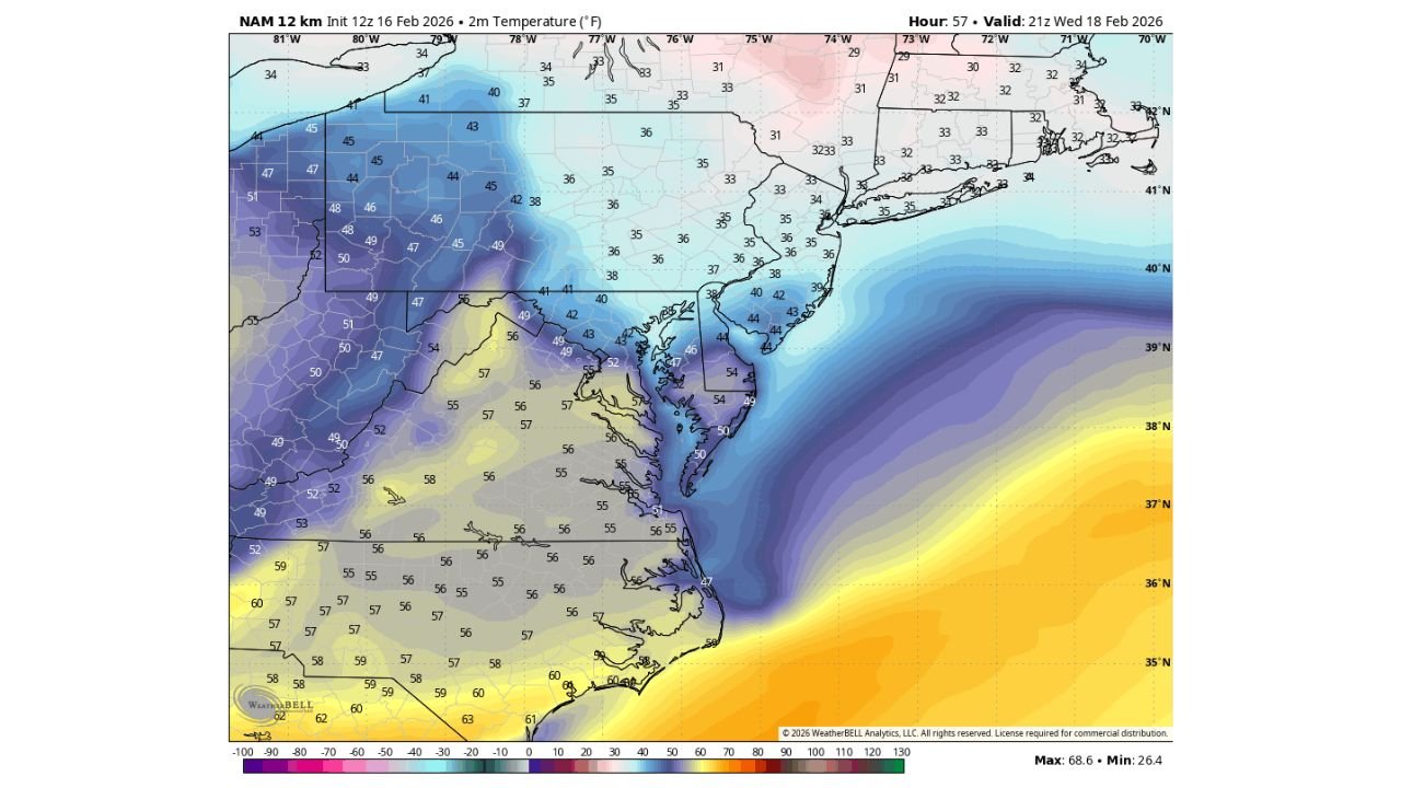
Forecast guidance valid around 21z Wednesday (February 18, 2026) shows a dramatic temperature contrast setting up across the Mid-Atlantic. Areas north of the boundary — including parts of northern Maryland and southern Pennsylvania — are projected to sit in the upper 30s to low 40s, while locations south of the front could remain in the mid-50s to even low 60s.
This kind of cold air damming (CAD) scenario is notoriously difficult to forecast — and often leads to busted temperature projections.
A Classic Backdoor Front Setup
Unlike typical cold fronts that sweep west to east, a backdoor front pushes in from the northeast, funneling cooler Atlantic air inland. The latest model run suggests this boundary could slip down the Chesapeake Bay and into the Baltimore metro region during the middle of the week.
Model temperature shading shows:
- Low 40s across central and northern Maryland
- Mid to upper 30s extending into southern Pennsylvania
- 50s holding south of the boundary across portions of southern Virginia and North Carolina
- Coastal influence keeping eastern Maryland cooler longer
If the front arrives earlier or pushes farther south than expected, Baltimore could struggle to escape the low 40s. If it stalls north, milder air could briefly surge northward before the cooler air wins out.
Why This Pattern Is So Tricky
Backdoor fronts tied to CAD setups are especially challenging because:
- Cold air can undercut warmer air quickly
- Cloud cover can lock temperatures in place
- Wind direction shifts dramatically over short distances
- Temperature differences of 15–20 degrees can occur within just a few counties
Forecast maps show the gradient tightening dramatically between western Maryland and the Chesapeake region — a sign that even small shifts in the boundary could mean major temperature swings.
Don’t Count on a Big Baltimore Warmup Yet
Earlier outlooks suggested a broader warming trend for the region, but this new model run raises caution flags. With the boundary potentially slicing directly through Maryland, Baltimore’s forecast remains uncertain heading into midweek.
If the front settles south of the city:
- Highs may stay in the 40s
- Overcast skies could dominate
- Northeast winds may keep a chill in place
If it stalls north:
- Mid to upper 50s remain possible
- Partial sun could develop
- The warm sector briefly wins
For now, this setup favors a sharp north-south temperature divide rather than uniform warmth.
What to Watch Over the Next 48 Hours
Forecasters will be monitoring:
- Placement of the surface low pressure system
- Strength and position of the high pressure to the north
- Timing of the backdoor boundary push
- Wind direction trends near the Chesapeake Bay
Even small adjustments in those factors could determine whether Baltimore ends up in the cool zone or the mild zone.
This is a developing situation — and one that often surprises even experienced meteorologists.
Stay tuned to ChicagoMusicGuide.com for continued updates as the midweek temperature battle across Maryland comes into sharper focus.