
Baltimore Metro Winter Storm Outlook: 20–50% Chance of 3+ Inches of Snow as Sunday–Monday System Brings Rain, Mix, or Snow
BALTIMORE, MARYLAND — A developing Sunday–Monday storm system is drawing growing attention across the Baltimore Metro area, with new ensemble model data showing measurable snow potential alongside the likelihood of rain or a wintry mix. While details remain uncertain, forecasters agree the system is unlikely to completely miss the region.
Recent ensemble guidance highlights a meaningful probability of accumulating snowfall. At the same time, temperatures hovering above freezing could limit how much snow sticks, keeping the forecast highly conditional as the weekend approaches.
Snow Probability Signals Increase Across Baltimore Metro
Multiple ensemble models are now showing chances for at least 3 inches of snowfall (10:1 ratio) across Maryland, particularly in and around Baltimore.
- The ECMWF Ensemble (Euro Ens) indicates a 20–30% chance of 3 inches or more in the Baltimore Metro.
- The ECMWF AIFS Ensemble raises that probability to 40–50%.
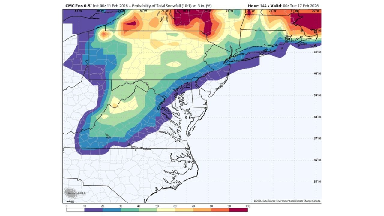
- The CMC Ensemble (Canadian model) shows a 30–40% chance, and has reportedly been the most consistent in producing snow in this region.
These probabilities do not guarantee snowfall totals but confirm that accumulating snow is firmly on the table. Importantly, none of the guidance currently suggests a clear “miss” scenario for Baltimore.
The signal favors a system capable of producing widespread precipitation, though the exact precipitation type remains uncertain.
Rain, Sleet, or Snow? Temperatures Are the Key Factor
One of the most critical forecast elements involves surface temperatures across Maryland and the broader Mid-Atlantic region.
Confidence is increasing that ground-level temperatures during the heaviest precipitation period will likely be above freezing, potentially rising into the 40s. That factor significantly reduces the odds of impactful wintry accumulation, especially in lower elevations and urban corridors like downtown Baltimore.
However, marginal temperatures also mean:
- A brief period of snow at onset is possible.
- A transition to sleet or mixed precipitation could occur.
- Heavier bursts may temporarily cool the surface enough for localized accumulation.
Because temperatures appear borderline rather than deeply cold, the most likely scenario currently leans toward moderate to heavy rain with the possibility of a brief wintry mix, rather than a prolonged heavy snow event.
Timing Window: Sunday Morning Through Monday Morning
Forecast timing suggests that precipitation across the Baltimore–Washington corridor would most likely occur between Sunday morning and Monday morning.
Key points regarding timing include:
- The main precipitation shield could arrive Sunday morning.
- The heaviest precipitation would likely fall Sunday afternoon or evening.
- Lingering precipitation may taper early Monday.
Model spread remains wide, ranging from solutions that bring over an inch of liquid-equivalent precipitation to scenarios where the storm tracks farther south and only grazes the region.
Forecasters note that clearer trends may emerge by midday Thursday, when additional model runs refine the storm’s track and thermal profile.
Why This System Matters for the Region
The Mid-Atlantic has experienced a mix of winter weather patterns this season, and another potential winter event draws heightened attention—especially with recent colder stretches still fresh in memory.
Even though current data suggests that any impactful winter accumulation is fairly low in probability, the presence of ensemble support for measurable snow means residents should not dismiss the system outright.
For now, the most balanced takeaway is this:
- The storm is unlikely to be a complete miss.
- It could bring moderate to heavy rain.
- A brief period of snow or wintry mix remains possible.
- Surface temperatures likely limit major snow accumulation.
Small shifts in track or thermal structure could dramatically alter the outcome.
As the weekend approaches, confidence levels will increase, and a clearer picture will emerge for Baltimore, central Maryland, and surrounding areas.
For the latest weather developments, storm tracking updates, and detailed breakdowns that impact your plans and local events, keep checking back with ChicagoMusicGuide.com.