
Baltimore Weekend Storm Forecast Shows Sharp Model Split as ECMWF Signals Possible Snow North and West of I-95 Sunday Night
BALTIMORE, MARYLAND — A developing Sunday storm system is creating unusual uncertainty across the Baltimore region, with weather models still sharply divided just two days before impact. While some projections keep the system largely south of the city, the latest ECMWF model guidance indicates precipitation is likely, with a potential for snow north and west of I-95 Sunday night and rain elsewhere.
Forecasters say temperatures should remain above freezing, meaning even where snow does fall, it may struggle to stick — especially on roadways.
ECMWF Model Points to Precipitation Reaching Baltimore
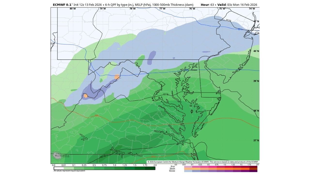
The latest ECMWF 0.1° model run (initialized 12Z February 13, valid 03Z Monday, February 16) shows a broad swath of precipitation extending across Maryland, northern Virginia, and into southern Pennsylvania. According to the model’s QPF output, measurable precipitation is expected across the Baltimore metro area, contradicting earlier model runs that suggested the city could be missed entirely.
The precipitation shield appears strongest south of Baltimore, with heavier rain totals projected across central and southern Maryland, including areas closer to Washington, D.C. Meanwhile, a transition zone sets up across northern Maryland and into southern Pennsylvania.
This evolving forecast highlights the ongoing model disagreement that has persisted through Friday — a rare scenario given the short lead time before a Sunday system.
Snow Risk North and West of I-95
The most notable detail in the ECMWF output is the potential for snow Sunday night north and west of I-95, including parts of Baltimore County, Carroll County, Frederick County, and into southern Pennsylvania.
The model’s precipitation type breakdown indicates:
- Rain across most of central Maryland
- A rain-to-snow mix zone northwest of Baltimore
- Higher probability of snow accumulation farther inland and at slightly higher elevations
However, the 1000–500mb thickness values and surface temperatures suggest marginal thermal profiles. With forecast readings staying just above freezing in much of the region — even overnight — any snow that falls may have difficulty accumulating on paved surfaces.
Grass, elevated surfaces, and untreated areas would be more likely to see minor coatings if snowfall rates briefly intensify.
Temperatures Remain the Wild Card
One of the biggest limiting factors for accumulation is temperature. Model guidance indicates readings hovering in the mid-30s Sunday night across Baltimore, only dipping marginally lower in outlying suburbs.
Above-freezing ground temperatures following recent milder days further reduce the chance for widespread sticking snow. Even in areas where snow mixes in, melting could occur quickly between bursts of precipitation.
If precipitation rates are heavy enough, brief dynamic cooling could allow snow to accumulate in localized spots. But at this time, forecasters emphasize that any accumulation risk appears limited and highly elevation-dependent.
Why the Models Still Disagree
The continued split between guidance likely stems from the precise track of the developing low-pressure system. A slight shift north or south could dramatically alter precipitation type and totals across the Baltimore region.
Some model runs suppress the system farther south, keeping Baltimore mostly dry. Others — including the most recent ECMWF run — expand the precipitation shield northward enough to impact much of central Maryland.
With the event still evolving, small adjustments in track or timing could shift the rain-snow line by 20 to 40 miles — a critical detail in determining who sees flakes versus just cold rain.
What Baltimore Residents Should Expect
At this stage, the most probable scenario for Baltimore City and areas along I-95 is:
- Rain Sunday evening
- Possible brief mix late Sunday night
- Limited to no accumulation within the city
Communities north and west of the metro core have a higher chance of seeing snow mix in, especially toward the Pennsylvania border.
Drivers should remain alert Sunday night, particularly in northern suburbs where untreated surfaces could briefly become slick if snowfall rates increase.
As this weekend storm approaches, forecast adjustments remain possible through Saturday and early Sunday.
For continued updates on Maryland weather systems, regional forecasts, and storm tracking across the Mid-Atlantic, visit ChicagoMusicGuide.com for the latest coverage.