
British Columbia and Washington Face Major Mountain Snowstorm as Atmospheric River Collides With Arctic Air Near Vancouver
VANCOUVER, BRITISH COLUMBIA — Meteorologists are closely monitoring a potentially significant winter storm developing across southwestern British Columbia and northern Washington State, where a powerful weather pattern could bring heavy snowfall to mountain regions while lower elevations near Vancouver may also see snow early in the week.
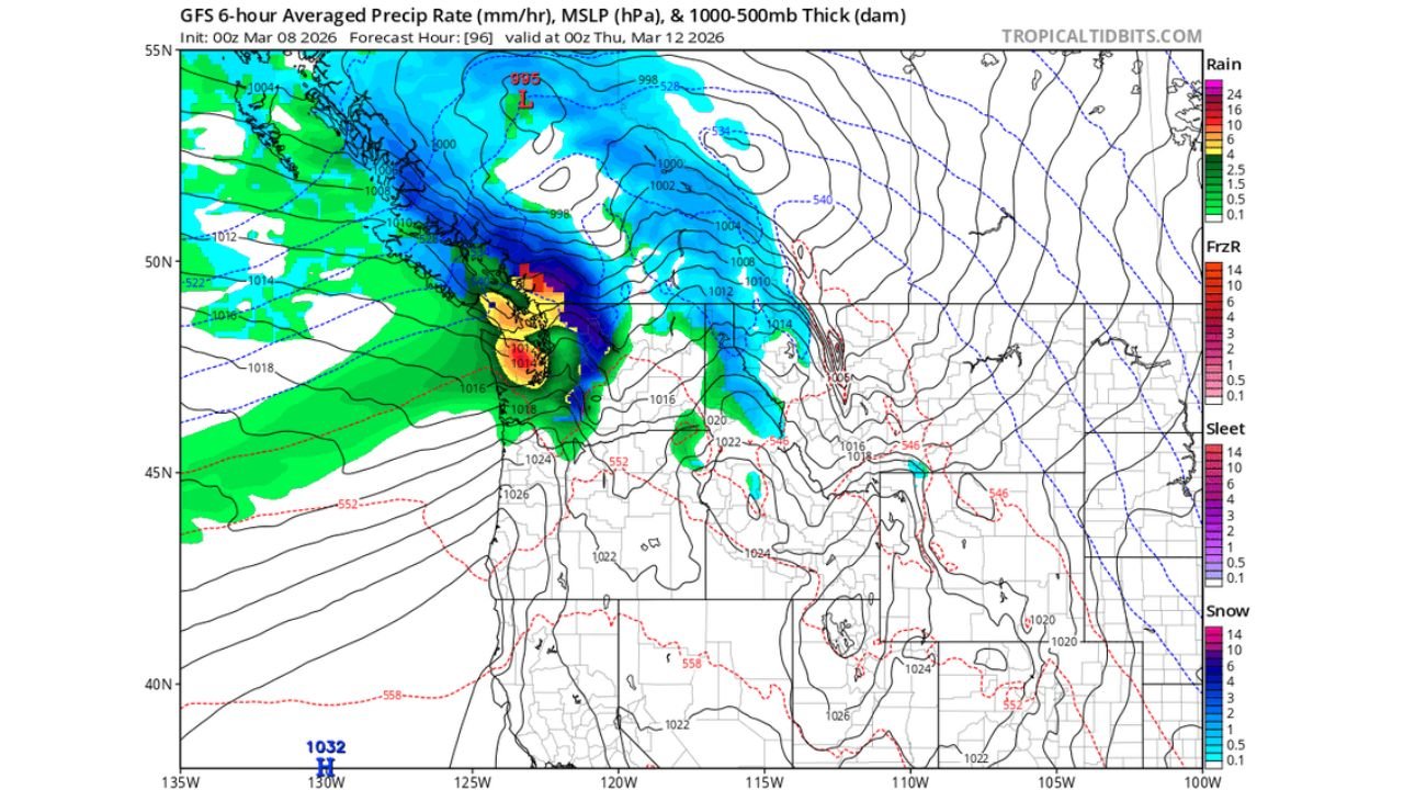
Forecast models indicate that Monday and Tuesday could bring snow chances to lower elevations near Vancouver, while the mountains of southwestern British Columbia and the North Cascades in Washington may face a much more intense winter storm later in the week. The system is expected to intensify as a moist atmospheric river collides with incoming Arctic air, creating a powerful setup capable of producing extremely heavy snowfall at higher elevations.
Atmospheric River Expected to Deliver Heavy Moisture Into British Columbia
Weather models including both the GFS and European forecast systems are showing similar patterns, increasing confidence that a large storm system will develop over the northeastern Pacific and move toward British Columbia and the Pacific Northwest.
This storm is expected to push a deep plume of Pacific moisture toward the coast of British Columbia, a phenomenon commonly known as an atmospheric river. These events transport large amounts of moisture from the Pacific Ocean into coastal regions, often producing prolonged periods of heavy precipitation.
As the system approaches the coast, much of that moisture will be forced upward by the mountainous terrain of southwestern British Columbia, dramatically increasing snowfall rates at higher elevations.
Mountain Regions of British Columbia and Washington Could See Massive Snow Totals
Forecast projections suggest that mountain areas above roughly 1,000 meters elevation in southwestern British Columbia could receive extraordinary snowfall totals over the next week. Some projections indicate 200 to 300 centimeters or more of snowfall may accumulate across the highest terrain.
Major mountain locations such as Garibaldi Provincial Park, Whistler, and the mountains surrounding Vancouver could experience the most extreme snowfall totals, particularly where elevations exceed 800 to 1,000 meters.
Across the border in the United States, the North Cascades in Washington State could also see heavy snowfall as the storm moves inland. These mountains are highly susceptible to major winter storms when Pacific moisture interacts with colder air masses.
Meteorologists say snowfall in these mountain regions could reach several feet and potentially more than a meter in the most favorable locations, especially if colder air remains locked in place.
Low Elevation Snow Possible Near Vancouver Early in the Week
Before the most intense snowfall reaches the mountains, lower elevations near Vancouver may briefly see snow during the early stages of the storm, particularly Monday and Tuesday.
Forecast models suggest a period of colder Arctic air moving southward into British Columbia, which could lower snow levels temporarily. If temperatures remain cold enough, some snowfall could reach lower elevations around the Vancouver metro area.
However, forecasters note that temperature changes will play a critical role, meaning precipitation near sea level could alternate between rain and snow depending on how the system evolves.
Storm Could Trigger Widespread Winter Travel Issues in the Region
If current model projections hold, the upcoming storm could bring major winter travel disruptions across highways in southwestern British Columbia and parts of Washington State.
Mountain routes connecting Vancouver with interior British Columbia, as well as roads through the North Cascades in Washington, could experience dangerous travel conditions due to heavy snowfall and strong winds.
Meteorologists say the setup resembles a classic Pacific Northwest winter storm pattern, where intense moisture collides with colder air flowing south from Canada.
Some forecasters also point to La Niña climate conditions in the Pacific, which can sometimes increase storm activity and snowfall across the Pacific Northwest during late winter.
Meteorologists Watching Forecast Trends Closely
Despite strong signals from multiple forecast models, meteorologists caution that the exact timing and snowfall totals will continue to evolve over the coming days. Forecasters plan to watch whether model runs continue showing the same storm intensity over the next 24 hours before issuing stronger alerts.
If the storm develops as projected, winter storm warnings could eventually be issued across southwestern British Columbia and parts of Washington, particularly for higher mountain terrain where the heaviest snow is expected.
Residents and travelers across British Columbia and Washington are encouraged to monitor forecast updates closely as meteorologists refine their projections.
As the storm approaches the Pacific Northwest, ChicagoMusicGuide.com will continue tracking developing winter weather across British Columbia, Washington State, and the surrounding mountain regions.