
Brutal Arctic Blast Targets Washington DC, Virginia, Maryland, New York, and Massachusetts as Winter’s Harshest Stretch Unfolds
UNITED STATES — A powerful Arctic air mass originating near Siberia is surging into the eastern United States, setting up what forecasters describe as the harshest 24-hour stretch of winter so far from Friday night through Saturday. The outbreak will impact a wide swath of the Mid-Atlantic, Northeast, and Great Lakes, bringing dangerous wind chills, scattered snow squalls, and localized heavy snowfall bands depending on location.
Arctic Air Surges South From the Polar Region
Forecast data shows the Arctic air mass plunging south from Severny Island in the Arctic Circle, reaching the Washington, DC region by Friday night. This direct north-to-south trajectory explains the sudden intensity of the cold, with little moderation before arrival.
This setup favors rapid temperature drops, aggressive wind increases, and a short but severe window of winter weather impacts.
Snow Showers and Squalls Friday Afternoon Into Evening
As the Arctic front pushes through, snow showers and brief snow squalls are expected Friday afternoon into early evening across parts of Virginia, Maryland, Pennsylvania, and the DC metro area.
These snow bursts will be:
- Hit-or-miss in coverage
- Capable of briefly lowering visibility
- Able to create slick roads during the evening commute
- Generally light in accumulation, but impactful due to timing and wind
Most locations will see coatings to light accumulations, but squalls could briefly whiten roadways before winds take over.
Winds Ramp Up Overnight With Power Outage Risk
By late Friday night into Saturday morning, winds increase dramatically, especially across higher terrain and exposed areas.
Forecast wind gusts include:
- 35+ mph across much of the Mid-Atlantic
- 40–50 mph common in open areas
- 50+ mph possible in the Allegheny Front and Blue Ridge Mountains
Wind advisories are likely, with high wind warnings in the mountains, and scattered power outages are possible where gusts peak.
Extreme Cold Watches and Warnings Expand Across the Region
Extreme Cold Watches are in effect from 4 AM Saturday through 10 AM Sunday across much of the region, with some areas already upgraded to Extreme Cold Warnings.
Expected wind chill ranges include:
- 0 to –10°F east of the Blue Ridge
- –10 to –25°F west of the Blue Ridge
- –20 to –30°F in the Allegheny Front and higher elevations
Forecasters warn that frostbite and hypothermia can occur in minutes if skin is exposed.
Rochester and Western New York Face Lake-Effect Snow and Dangerous Cold
In New York, especially near Rochester and Lake Ontario, lake-effect processes will add another layer of impact.
Snowfall expectations through Saturday night include:
- 1–3 inches for most areas
- 3–6 inches in favored lake-effect zones
- Localized 6+ inches where narrow squalls persist
Even lighter totals will be problematic due to blowing snow, rapidly falling temperatures, and wind chills near –25°F early Saturday.
Eastern Massachusetts Could See Narrow Heavy Snow Bands
Saturday’s snow setup in Massachusetts favors very narrow but intense snow bands, especially across eastern Massachusetts.
Forecast breakdown:
- Most towns: 1–3 inches
- Coastal and eastern sections: 3–5 inches
- Isolated communities: 5–8 inches under persistent bands
Only a handful of towns will see the highest totals, but those that do could experience rapid accumulation in a short time.
Saturday Timeline: Cold Dominates From Morning Through Night
Across impacted regions, Saturday unfolds in stages:
- Morning: Dangerous cold with scattered lake flakes and wind chills as low as –25°F
- Midday: Still brutally cold, with lingering snow showers
- Afternoon into evening: Snow diminishes, but cold remains locked in
- Night: Temperatures fall to 5–10°F, with sub-zero wind chills continuing
Actual air temperatures will struggle to rise out of the teens and low 20s in many areas.
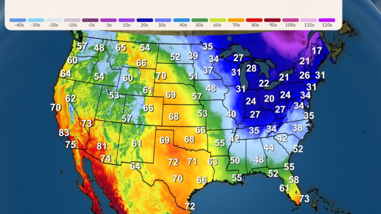
A Winter Pattern That Defies Expectations
National temperature and upper-air anomaly maps show a striking contrast:
- Western U.S. dominated by strong ridging and unusual warmth
- Central and Eastern U.S. locked under a deep trough
This has resulted in places like Portland, Oregon and Great Falls, Montana being as warm as or warmer than Tampa, Florida, a pattern that does not resemble a textbook La Niña winter.
Bottom Line
This is not a storm to measure by snowfall totals alone. The combination of Arctic air, powerful winds, scattered snow, and extreme wind chills will create a dangerous and unforgiving stretch of winter weather from Friday night through Saturday across multiple states.
Residents are urged to:
- Limit time outdoors
- Dress in multiple layers
- Protect pets and vulnerable individuals
- Prepare for power disruptions
The cold is the main story — and it demands respect.
Want more regional winter breakdowns, live weather impacts, and how conditions could affect upcoming concerts and events? Stay connected with ChicagoMusicGuide.com and check back as conditions evolve.