
California and Texas Targeted for Rain Comeback March 31–April 6 as Southern California Heat Eases and 40–60 Percent Odds Favor Meaningful Totals
CALIFORNIA — After another week dominated by Southern California heat, a noticeable pattern change is taking shape for the first week of April, with rain chances increasing across parts of the state and into Texas.
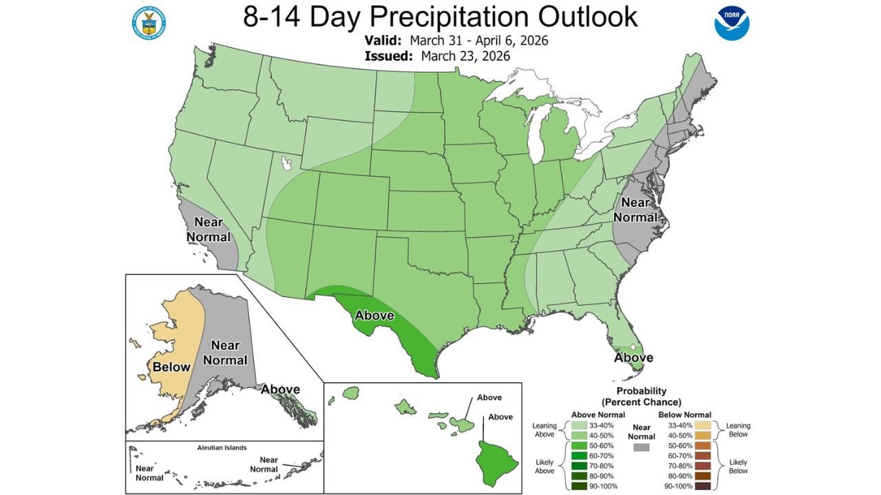
The latest 8–14 day precipitation outlook, valid March 31 through April 6, 2026, signals a shift toward wetter conditions in portions of Southern California and South Texas, marking a potential break from the persistent warmth.
Southern California Watching for Rain Return
Following multiple rounds of above-normal temperatures across Los Angeles, San Diego, Riverside and surrounding areas, ensemble guidance now suggests measurable rainfall could return during the opening days of April.
Forecast probabilities indicate:
- Roughly 40–60 percent odds of rainfall totals exceeding 0.50 inches
- Approximately 10–20 percent odds of totals exceeding 1 inch
While not signaling a major storm system at this time, these probabilities are notable given the recent dry and warm pattern across the region.
Much of coastal and inland Southern California is currently projected to trend near normal to slightly above normal in precipitation, but localized enhancements could develop depending on storm track and moisture transport.
Texas Also Favored for Above-Normal Precipitation
The outlook also highlights South Texas, including areas near Corpus Christi and Brownsville, in a stronger above-normal precipitation zone.
Darker shading across southern portions of the state suggests higher confidence in wetter-than-average conditions compared to surrounding regions.
This aligns with a broader storm track pattern that appears to direct moisture into the southern tier of the United States as April begins.
Near-Normal Conditions Across the East
While the West and southern tier show increasing rain signals, much of the Mid-Atlantic and Northeast, including New York, Pennsylvania and the Carolinas, are projected to see near-normal precipitation during this same timeframe.
Similarly, large sections of the central Plains and Midwest show modest above-normal precipitation signals, but not as pronounced as southern Texas.
Heat Pattern Begins to Relax
The anticipated rain return coincides with a likely easing of the most intense Southern California heat.
While temperatures may still run seasonably mild, the dominant ridge responsible for repeated warm episodes is expected to weaken or shift, allowing more active weather systems to move through.
For residents across Southern California, the first week of April may feel noticeably different compared to the recent stretch of persistent heat and dry conditions.
ChicagoMusicGuide.com will continue monitoring how this developing pattern change unfolds and provide updates as forecast confidence increases heading into early April.