
California, Arizona, Texas, and Oklahoma in Line for Major Rainmaker as New Pacific Storm Moves Inland This Weekend
CALIFORNIA – After a short break from the rain, Southern California is bracing for another powerful Pacific storm set to arrive by Thursday afternoon, bringing lowland rain, mountain snow, and a risk of coastal flooding. The system is expected to linger into the weekend before spreading across Arizona, New Mexico, Texas, and Oklahoma by early next week.
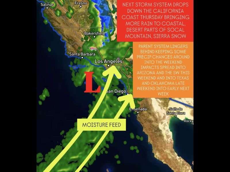
New Pacific System to Slam the California Coast
Meteorologists warn that the upcoming system will once again pull in deep Pacific moisture, targeting Los Angeles, San Diego, and coastal mountain regions.
Rain chances will increase through Thursday afternoon and Friday, with the potential for localized flooding, gusty winds, and even an isolated coastal waterspout or two.
A visible moisture feed on satellite imagery shows long plumes of subtropical air streaming straight into the California coastline — a setup that could drop significant rainfall totals in coastal and desert valleys, plus heavy snow in the Sierra Nevada and higher mountains of Southern California.
Meteorologists caution that although totals won’t rival early-season atmospheric rivers, the ground remains saturated, which raises the flood risk in low-lying and burn scar areas.
Storm Lingers, Then Pushes Inland Toward the Southwest
Once the main front passes Friday, the parent system will linger offshore, keeping showers and storms around Southern California through part of the weekend.
By Saturday, the core of the storm begins moving inland into Arizona and the Desert Southwest, spreading showers into Phoenix, Tucson, and Flagstaff. Forecasters say the system’s slow movement will allow lingering moisture and pockets of instability, potentially triggering isolated thunderstorms in the desert areas.
One meteorologist explained that “the upper low will crawl eastward, keeping rain chances alive for the weekend before re-energizing over Texas and Oklahoma early next week.”
That means multiple states could experience back-to-back rain events before the system finally clears out by Tuesday.
Texas and Oklahoma Could See Late-Weekend Storms
The same system expected to soak California and the Southwest will reach Texas and Oklahoma by Sunday night into Monday, bringing another wave of showers, storms, and possibly heavy downpours.
Forecast models show a broad shield of rain forming as the low-pressure center interacts with Gulf moisture, which could bring isolated flooding issues to north-central Texas and parts of Oklahoma.
If the pattern holds, it could set up a soggy start to Thanksgiving week for large portions of the central United States.
Online Reactions: ‘California Just Can’t Catch a Break’
Social media is already buzzing with posts showing the forecast maps labeled “Moisture Feed Reloaded.” Many Californians are venting and joking about yet another storm system interrupting weekend plans.
One user from Los Angeles wrote on X (formerly Twitter):
“Every time I wash my car, another Pacific storm decides to visit. I’m done.”
Another from San Diego posted:
“We just got sunshine for two days and now it’s back to rain boots and traffic jams.”
Meanwhile, weather enthusiasts across the Southwest are sharing excitement about potential mountain snow totals and hoping for a white Thanksgiving in higher elevations.
Prepare for Wet Travel and Flood Risks
Meteorologists urge residents in Southern California and Arizona to stay alert for updated flood watches and travel disruptions, especially in mountain passes and desert routes like I-8 and I-10.
For those in Texas and Oklahoma, it’s a good idea to plan for wet roads and possible thunderstorms late Sunday into Monday.
What Do You Think?
Will this Pacific storm bring more chaos to holiday travel, or are you ready for another round of much-needed rain? Share your thoughts and join the conversation at chicagomusicguide.com.